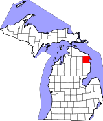
Alpena County, Michigan Basics:


Alpena County Michigan - Government Site

Population: 29,244
Area: 572 square miles
County seat: Alpena
Area code(s) in use: 989
Time zone: EST
High school graduate or higher: 88.6%
Bachelor's degree or higher: 16.0%
Median household income: $38,900
Persons in poverty: 16.8%
Home ownership rate: 78.9%
Mean travel time to work: 16.2 minutes


Adjacent counties:
Alcona  Montmorency  Oscoda  Presque Isle  

Find in Michigan

Map of the Alpena County area


Our detail map of Alpena County shows the Alpena County, Michigan boundary lines and other interesting items.

Places in Alpena County, Michigan

  Airports     show all on map

Alpena County Regional Airport, Baarlear Landing Strip, Silver City Airpark

  Bays     show all on map

El Cajon Bay, Huron Bay, Isaacson Bay, Lincoln Bay, Misery Bay, Morris Bay, Roberts Cove, Squaw Bay, Thunder Bay

  Bridges     show all on map

Orchard Hill Bridge

  Buildings     show all on map

Alpena Combat Readiness Training Center Fire and Rescue Services, Alpena County Courthouse, Alpena County Library, Alpena County Sheriff's Office, Alpena Fire Department, Alpena Police Department, Alpena Township Fire Department Station 1, Alpena Township Fire Department Station 2, Great Lakes Maritime Heritage Center, Green Township Volunteer Fire Department, Jesse Besser Museum, Long Rapids Township Fire Department, Maple Ridge Township Fire Department, Michigan Department of Natural Resources Alpena Field Office, Ossineke Township Hall, Sanborn Township Fire Department, Wilson Township Fire and Rescue

  Capes     show all on map

Bare Point, Breezy Point, Hardwood Point, Monaghan Point, North Point, Partridge Point, Potter Point, South Ninemile Point, South Point, Stoneycroft Point, Stony Point, Whitefish Point

  Cemeteries     show all on map

Cathro Cemetery (historical), Evergreen Cemetery, German Cemetery, Grace Lutheran Cemetery, Green Cemetery, Hebrew Benevolent Society Cemetery, Herron Saint Rose's Cemetery, Holy Cross Cemetery, Hubbard Lake Cemetery, Leer Lutheran Church Cemetery, Long Rapids Cemetery, Pilgrims Rest Cemetery, Pine Grove Cemetery, Saint Catherine's Cemetery, Saint Matthew Cemetery, Saint Paul Cemetery, Salem Lutheran Church Cemetery, Sanborn Township Cemetery, Spratt Cemetery, Wilson Cemetery

  Census     show all on map

Ossineke Census Designated Place

  Churches     show all on map

Alpena Apostolic Assembly Church, Alpena Baptist Church, Alpena Christian Church, Alpena Community of Christ Church, Beaver Lake Church, Cathro Community Baptist Church, Church of Christ, Church of Jesus Christ of Latter Day Saints, Community Church, Community of Christ Church, Faith Evangelical Lutheran Church, First Assembly of God Church, First Baptist Church, First Church of God, First Congregational United Church of Christ, First Presbyterian Church, First United Methodist Church, Free Methodist Church, Good Shepherd Lutheran Church, Grace Church, Grace Lutheran Church, Greeley Church, Greely Baptist Church, Hope Lutheran Church, Hubbard Lake Baptist Church, Huron Shores Fellowship Church, Immanuel Lutheran Church, Kingdom Hall of Jehovah's Witnesses, Kingdom Hall of Jehovah's Witnesses, Leer Church, Liberty Baptist Church, Lighthouse Baptist Church, Living Hope Church, Long Rapids Congregational Church, New Life Christian Fellowship Church, Northland Baptist Church, Ossineke United Methodist Church, River of Life Christian Church, Saint Anne Catholic Church, Saint Bernard Catholic Church, Saint Catherine Church, Saint John the Baptist Catholic Church, Saint Mary Church, Saint Matthew Church, Saint Paul Church, Saint Paul Lutheran Church, Salem Church, Salvation Army Church, Shoreline Wesleyan Church, Spratt Church, Thunder Bay Baptist Church, Thunder Bay Baptist Church, Trinity Church, Trinity Episcopal Church, Under His Wing's Christian Church, Word of Life Baptist Church

  Dams     show all on map

Fourmile Dam, McConnell Dam, Norway Point Dam

  Forests     show all on map

Alpena State Forest, Thunder Bay River State Forest

  Hospitals     show all on map

Alcona Health Center, Alpena Medical Arts PC Clinic, Alpena Regional Medical Center, Baybrook Medical Center, Internal Medicine Clinic, North Side Medical Clinic, Pheonix Medical Group, Tendercare Alpena Nursing Home, Tendercare Green View Nursing Home

  Islands     show all on map

Bird Island, Cow Island, Crooked Island, Grass Island, Gull Island, Middle Island, Round Island, Scarecrow Island, Sugar Island, Sulphur Island, Thunder Bay Island

  Lakes     show all on map

Beaver Lake, Blue Lake, Conway Lake, Coombs Lake, Denton Lake, Devils Lake, Devils Lake, Elbow Lake, Fitzgerald Lake, Fletcher Pond, Grass Lake, Jacobs Lake, Long Lake, Middle Lake, Mud Lake, Mud Lake, Muskrat Farm Lake, Sylvester Lake, Zim Lake

  Locales     show all on map

Alpena Country Club, Alpena County Fairgrounds, Alpena Golf Club, Alpena Lighthouse, Alpena Mall, Bolton Station (historical), Campers Grove Campground, Cathro Station (historical), Cross Roads Plaza, Dafoe Station (historical), Giantway Plaza, Gilchrist Wharf, Kerston Station, Male Store, Middle Island Light, Ossineke Forest Campground, Ossineke Station, Paul Bunyan Kampground, Ripley Square Mall, Thunder Bay Island Light, Thunder Bay River State Forest Campground, Thunder Bay RV Park and Campground, Thunder Bay Shopping Center, Woodland Camp

  Military     show all on map

Alpena Army Air Field (historical)

  Mines     show all on map

Fussey Quarry

  Parks     show all on map

Alpena City Hall Historical Marker, Alpena County Courthouse Historical Marker, Alpena County Park, Alpena State Park, Arthur E Sytek Park, Bay View Park, Beaver Lake County Park, Blair Park, Daniel Carter Family Historical Marker, Duck Park, First Congregational Church Historical Marker, Long Lake County Park, Manning Hill Park, Maple Ridge County Park, McRae Park, Mich-E-Ke-Wis Park, Monarch Mill Historical Marker, Ossineke Park, Russel T Gleason Roadside Park, Saint Bernard Catholic Church Historical Marker, Sanborn Country Park, Thomson Park, World's Largest Cement Plant Historical Marker

  Populated Places     show all on map

Alpena, Alpena Junction, Ashland, Bolton, Cathro, Emerson Station, Flanders, Herron, Hubbard Lake, Lachine, Lakeshore Estates Mobile Home Park, Lakewood, Leer, Long Rapids, McHarg, Ossineke, Paxton, Riverview Estates Mobile Home Park, Rockport, Spratt, Sunrise Estates Mobile Home Community

  Post Offices     show all on map

Alpena Post Office, Bolton Post Office (historical), Cathro Post Office (historical), Dafoe Post Office (historical), East Side Post Office (historical), Flanders Post Office (historical), Herron Post Office, Hobson Post Office (historical), Hubbard Lake Post Office, Lachine Post Office, Leer Post Office (historical), Long Rapids Post Office (historical), McSorley Post Office (historical), Orchard Hill Post Office (historical), Ossineke Post Office, Spratt Post Office (historical), Walburg Post Office (historical)

  Reservoirs     show all on map

Fourmile Pond, Lake Besser, Lake Winyah

  Schools     show all on map

All Saints Catholic School, Alpena Community College, Alpena Senior High School, Baldwin School, Besser Junior High School, Besser Technical School, Bingham School, Cedar School, Central High School, Collins School, Doyle School, Gordon School, Green School, Green School, Greenwood School, Hill School, Hinks School, Immanuel Lutheran School, Ineke Township School, Kollen School, Lincoln School, Long Rapids School, Maple Ridge School, McPhee School, Northeast School of Wildlife Art, Pied Piper School, Reider School, Saint Anne School, Saint Bernard School, Saint John School, Sanborn School, Seventh Day Adventist Elementary School, Sunset School, Thunder Bay Junior High School, White School, Wilson School

  Streams     show all on map

Bean Creek, Beaver Creek, Berlinski Creek, Big Ravine Creek, Butterfield Creek, Butterfield Creek, Cranberry Creek, Devils River, Evans Creek, Fall Creek, Fitzgerald Creek, Fletcher Creek, Gaffney Creek, Grass Creek, Holcomb Creek, Indian Creek, Jewett Creek, King Creek, Kingsbury Creek, Little Wolf Creek, Long Lake Creek, Lower South Branch Thunder Bay River, McGinn Creek, McLary Creek, Morrison Creek, Mud Creek, North Branch Devils River, North Branch Thunder Bay River, Norwegian Creek, Precore Creek, Rayburn Creek, Robinson Creek, Schmitt Creek, Simmons Creek, South Branch Devils River, Spratt Creek, Thunder Bay River, Truax Creek, Widner Creek, Wolf Creek

  Summits     show all on map

Manning Hill

  Swamps     show all on map

Black River Swamp, Long Swamp, Smokey Hollow Swamp

  Towers     show all on map

Turtle Lake Lookout Tower, WATZ-AM (Alpena), WHSB-FM (Alpena)

  Trails     show all on map

Devils Lake Trail, Norway Ridge Trail,

Alpena County, Michigan Population By Race (2012 estimate)

RacePopulation
WhiteAlpena County White population 28,48428,483  
MixedAlpena County Mixed population 322321
AsianAlpena County Asian population 175175
American IndianAlpena County American Indian population 146146
BlackAlpena County Black population 117116
Hawaiian & Pacific IslanderAlpena County Hawaiian & Pacific Islander population 2929

Additional population tables :
State population table
Michigan population by county