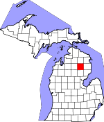
Oscoda County, Michigan Basics:


Oscoda County Michigan - Government Site

Population: 8,588
Area: 566 square miles
County seat: Mio
Area code(s) in use: 989
Time zone: EST
High school graduate or higher: 81.9%
Bachelor's degree or higher: 9.6%
Median household income: $33,942
Persons in poverty: 20.1%
Home ownership rate: 84.9%
Mean travel time to work: 21.9 minutes


Adjacent counties:
Alcona  Alpena  Crawford  Iosco  Montmorency  Ogemaw  Otsego  Roscommon  

Find in Michigan

Map of the Oscoda County area


Our detail map of Oscoda County shows the Oscoda County, Michigan boundary lines and other interesting items.

Places in Oscoda County, Michigan

  Airports     show all on map

Garland Airport, Lost Creek Airport, Oscoda County Airport

  Bridges     show all on map

Camp Ten Bridge, Parmalee Bridge

  Buildings     show all on map

Big Creek Township Hall, Comins Township Hall, Elmer Township Hall, Fairview Fire Department, Greenwood Township Volunteer Fire Department Station 1, Greenwood Township Volunteer Fire Department Station 2, Luzerne Fire Department, Mentor Township - McKinley Fire Department, Mentor Township Hall, Michigan Department of Natural Resources Mio Field Office, Michigan Magazine Museum, Oscoda County Ambulance Service, Oscoda County Courthouse, Oscoda County Library, Oscoda County Sheriff's Office, Steiner Museum, Tri - Town Fire Department, United States Forest Service Mio Ranger District, Werners Hotel

  Cemeteries     show all on map

Comins Cemetery, Fairview Cemetery, Hughes Grave, Indian Graves, Kittle Cemetery, Lincoln B Watson Grave, Long Lake Cemetery, Luzerne Cemetery, McKinley Cemetery, Mio Cemetery, Mooney Cemetery, Mount Pindus Cemetery, Muskrat Lake Cemetery, Rich Cemetery, Union Corners Cemetery, Weaver Cemetery

  Census     show all on map

Mio Census Designated Place

  Churches     show all on map

Church of Christ, Comins Mennonite Church, Conservative Mennonite Church, Emma Lowery Congregational Church, Fairview Mennonite Church, Faith Baptist Church, Grace Apostolic Church, Kingdom Hall of Jehovah's Witnesses, Living Water Lutheran Church, Luzerne Baptist Church, Mio Baptist Church, Mio Church of God, Mio Foursquares Church, Mio Seventh Day Adventist Church, Mio United Methodist Church, New Hope Assembly of God Church, Saint Bartholomew Episcopal Church, Saint Johns Evangelical Lutheran Church, Saint Mary's Catholic Church

  Flats     show all on map

Comins Flats

  Forests     show all on map

Huron National Forest, Oscoda State Forest

  Hospitals     show all on map

Au Sable Valley Health Center

  Lakes     show all on map

Abbott Lake, Bass Lake, Big Ward Lake, Bird Lake, Black Lake, Briggs Lake, Cedar Lake, Churchill Lake, Crane Lake, Crater Lake, Dollar Lake, Dollar Lake, Durkee Lake, Dutch Lake, Echo Lake, Elmer Lake, Emley Lake, Glenn Lake, Happy Lake, Hidden Lake, Horseshoe Lake, Hughes Lake, Hughes Lake, Hunt Pond, Indian Lake, Indian Lake, Island Lake, Island Lake, Island Lake, La Belle Lake, Lake David, Little Bass Lake, Little Bear Lake, Little Ward Lake, Loon Lake, Lost Lakes, Luzerne Pond, Mack Lake, McCollum Lake, McCreedie Lake, McGraw Lake, Moon Lake, Mud Lake, Mud Lake, Muskrat Lake, Noodles Lake, North Helmer Lake, North Twin Lake, Oak Lake, Penoger Lake, Perch Lake, Perry Lake, Perry Lake, Pickerel Lake, Pike Lakes, Pots Lake, Rhoads Lake, Rienstein Lake, Rudd Lake, Saddleback Lake, Second Lake, Shamrock Lake, Shaw Lake, Shear Lake, Sherwood Pond, Shoonemaker Lake, Smith Lake, Snyder Lake, South Helmer Lake, Spring Lake, Tea Lake, Thompson Lake, Three Lakes, Tote Road Lake, Twin Lake, Wagner Lake, Walleye Rearway Pond, Whitabee Lake, Wood Lake, Young Lake

  Locales     show all on map

Camp Barakel, Cedar Valley Golf Club, Comins Station (historical), Cowhand Ranch, Fairview Hills Golf Course, Garland Fountains Golf Course, Garland Monarch Golf Course, Garland Reflections Golf Course, Garland Swampfire Golf Course, Homestead Hunting Club, Indian Village Boys Camp, Island Lake Recreation Area, Lewiston Shady Acres Campground, Loon Lake Recreation Site, Luzerne Campground, Luzerne Fire Point of Interest, Luzerne Trail Camp, Mack Lake Recreation Area, McCollum Lake Recreation Site, McKinley Station (historical), McKinley Trail Camp, Millen Station (historical), Mio Mountain Ski Area, Mio Pine Acres Campground, Mio Pond State Forest Campground and Group Camp, Muskrat Lake State Forest Campground, Parmalee Bridge Recreation Site, Paul Bunyon Camp, Sherwood Corners, Shotgun Corners, Sidewinder Golf Course, Union Corners, Wagner Lake Campground

  Parks     show all on map

Au Sable National Scenic River, Luzerne Park, Mio Hydroelectric Plant Historical Marker, Oscoda County Courthouse Historical Marker, Oscoda County Historical Marker, Oscoda County Park, Smith Lake Park, Wayside Recreation Site

  Populated Places     show all on map

Biggs Settlement, Comins, Fairview, Kneeland, Luzerne, McKinley, Mio, Red Oak

  Post Offices     show all on map

Biggs Post Office (historical), Comins Post Office, Fairview Post Office, Indian Lake Post Office (historical), Kneeland Post Office (historical), Luzerne Post Office, Mack City Post Office (historical), McKinley Post Office (historical), Mio Post Office, Odessa Post Office (historical), Red Oak Post Office (historical), Royce Post Office (historical), Ryno Post Office (historical), Spoor Post Office (historical), Tyrrell Post Office (historical), Wood Post Office (historical)

  Reservoirs     show all on map

Mio Dam Pond

  Schools     show all on map

Fairview Area Schools, Mio AuSable School

  Springs     show all on map

Boiling Springs

  Streams     show all on map

Antler Creek, Beaver Creek, Big Creek, Boiling Spring Creek, Bullock Creek, Cauchy Creek, Cherry Creek, Comins Creek, East Branch Big Creek, Glennie Creek, Gusler Creek, Honeywell Creek, Hunt Creek, Joslin Creek, Lost Creek, Loud Creek, Marsh Creek, Ninemile Creek, Perry Creek, Pike Creek, Red Creek, Sohn Creek, West Branch Big Creek, Whitewater Creek, Wolf Creek, Wright Creek

  Summits     show all on map

Mio Mountain, Mount Tom, Timberline Mountain

  Swamps     show all on map

Church Lake, Comins Marsh, Gopher Lake, Grass Lake

  Towers     show all on map

Elk Hill Lookout Tower, Luzerne Lookout Tower, Mack Lake Lookout Tower, WFMA-FM (Mio),

Oscoda County, Michigan Population By Race (2012 estimate)

RacePopulation
WhiteOscoda County White population 8,3658,364  
MixedOscoda County Mixed population 129128
American IndianOscoda County American Indian population 6060
BlackOscoda County Black population 2625
AsianOscoda County Asian population 98
Hawaiian & Pacific IslanderOscoda County Hawaiian & Pacific Islander population 00

Additional population tables :
State population table
Michigan population by county