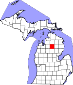
Crawford County, Michigan Basics:


Crawford County Michigan - Government Site

Population: 13,974
Area: 556 square miles
County seat: Grayling
Area code(s) in use: 989
Time zone: EST
High school graduate or higher: 84.8%
Bachelor's degree or higher: 15.2%
Median household income: $39,982
Persons in poverty: 18.7%
Home ownership rate: 81.3%
Mean travel time to work: 22.8 minutes


Adjacent counties:
Antrim  Kalkaska  Missaukee  Montmorency  Ogemaw  Oscoda  Otsego  Roscommon  

Find in Michigan

Map of the Crawford County area


Our detail map of Crawford County shows the Crawford County, Michigan boundary lines and other interesting items.

Places in Crawford County, Michigan

  Airports     show all on map

Grayling Army Airfield, Higgins Lake Airport, Kelleys Airport

  Areas     show all on map

South Branch Au Sable River Area

  Basins     show all on map

Juvigny Valley

  Bridges     show all on map

Blonde Dam Bridge, Cameron Bridge, Chase Bridge, Kelloggs Bridge, McMasters Bridge, Red Bridge, Smith Bridge, Steckert Bridge, Stephans Bridge

  Buildings     show all on map

Beaver Creek Fire Department, Crawford County Historical Museum, Crawford County Library, Crawford County Sheriff's Office, Frederic Community Library, Frederic Township Volunteer Fire Department, Frederic Township Volunteer Fire Department Ambulance Garage, Grayling City - Township Fire Department, Grayling Police Department, Grayling Township Hall, Lovells Township Fire Department, Lumbermens Museum, Major Hartwick Museum, Michigan Army National Guard Camp Grayling Fire Department, Michigan Department of Natural Resources Grayling Field Office, Mobile Medical Response Beaver Creek Fire Department, North Flight Emergency Medical Services, South Branch Township Fire and Emergency Medical Services, State Parks Central Warehouse

  Capes     show all on map

Big Bear Point, Eagle Point, Little Bear Point

  Cemeteries     show all on map

Ball Cemetery, Beaver Creek Cemetery, Cheney Cemetery, Elmwood Cemetery, Lovells Cemetery, Maple Forest Cemetery, Oakwood Cemetery, Pioneer Cemetery, Rock Cemetery, Shrine Cemetery, Stephan Cemetery, United States Government Military Cemetery

  Churches     show all on map

Abundant Life Tabernacle Church, Assembly of God Church, Burning Bush Tabernacle Church, Calvary Baptist Church, Church of Christ, First Baptist Church, Grayling Baptist Church, Grayling Community of Christ Church, Grayling Free Methodist Church, Heritage Baptist Church, Kingdom Hall of Jehovah's Witnesses, Lovells Community Chapel, Mason Chapel, Michelson Memorial United Church, Mount Hope Lutheran Church, Saint Francis Episcopal Church, Saint John Lutheran Church, Saint Mary's Church, Seventh Day Adventist Church, South Branch Church

  Crossings     show all on map

Interchange 249, Interchange 251, Interchange 254, Interchange 256, Interchange 259, Interchange 264

  Forests     show all on map

Au Sable State Forest, Higgins Lake State Forest

  Hospitals     show all on map

Au Sable Family Care Clinic, Au Sable Valley Homes, Grayling Family Practice Clinic, Grayling Nursing and Rehabilitation Community, Mercy Hospital - Grayling, Northern Care Walk-In Medical Clinic

  Lakes     show all on map

Barker Lake, Barnes Lake, Bear Lake, Beaver Lake, Blue Gill Lake, Bright Lake, Bull Frog Lake, Camel Lake, Camel Lake, Chub Lake, Clear Lake, Cranberry Lake, Duck Lake, Frog Lakes, Glory Lake, Hartwick Lake, Hiscock Lake, Horseshoe Lake, Howes Lake, Hunters Lake, Johnson Lake, Jones Lake, Karen Lake, Kellogg Lake, Kneff Lakes, KP Lake, Kyle Lake, Lake Margrethe, Little K P Lake, Little Shupac Lake, Lonesome Lake, Lost Lake, Marsh Lake, May Lake, Mud Lake, River Lake, Sand Hill Lake, Section One Lake, Shellenbarger Lake, Shupac Lake, Simpson Lakes, Staley Lake, Timber Lake, Wakeley Lake, West Lake

  Locales     show all on map

Alexander Station (historical), Au Sable River State Forest Campground and Canoe Camp, Au Sable State Forest Headquarters, Au Sable Trout and Gun Club, Bakers Cabins, Bass Lake Cabins, Bay City Hunting and Fishing Club, Beaver Creek Township Hall, Bell Top Lodge, Bucks Station (historical), Burton's Landing State Forest Campground, Camp 16, Camp Au Sable Club, Camp Ginger Quill, Camp Grayling, Camp Shoppenagon, Camp Wa-Wa-Sum, Conners Marsh Flooding, Deward Station (historical), Fayette Station (historical), Forest Cabins, Forest Dunes Golf Club, Fox Run Country Club, Frederic Station, Goose Creek State Forest Campground and Trail Camp, Grayling Fish Hatchery, Grayling Golf Club, Grayling Mall, Grayling Rest Area, Happi Days Campground and Diner, Hartwick Pines Rest Area, Hartwick Pines State Park Campground, Hawk Ridge Golf Course, Headwaters Camping and Cabins, Higgins Lake State Nursery, High Bank Lodge, Horrigans Siding, Johns Cabins, Jones Lake State Forest Campground, Kefalake Camp, Keystone Landing State Forest Campground, Kneelands Station (historical), Kneff Lakes Campground, Lake Margrethe State Forest Campground, Laurels Pine Well Cabins, Leykaufs Cabins, Lovells Station (historical), Lovells Town Hall, Manistee River Bridge State Forest Campground, Maple Forest Township Hall, Northern Block and Supply Company, Northern Michigan Speedway, Pere Cheney Station, Rainbow Bend Forest Campground, Rays Cabins, River Park Campgrounds, Shupac Lake State Forest Campground, Skyline Ski Slide, South Branch Campground, South Branch Ranch, Timberly Village Campground, Trails Campground, Upper Manistee River State Forest Campground, Wellington Farm Park, Whispering Pines Cabins, White Pine Campground, White Pine Canoe Camp

  Parks     show all on map

Beginning of State Reforestation Historical Marker, Chief Shoppenagon Historical Marker, Douglas House Historical Marker, Grayling Winter Recreation Area, Hanson State Game Refuge, Hartwick Pines State Park, Leary Park, Michigan Grayling Historical Marker, North Higgins Lake State Park, Officer's Club Historical Marker, Shoppenagon's Homesite Historical Marker, Thirty-Second Red Arrow Division Historical Marker, Thomas E Douglas Historical Marker

  Pillars     show all on map

McNamara Monument

  Populated Places     show all on map

Babbits Resort, Bucks, Collens Landing, Danish Landing, Deerheart Valley, Deward, Eldorado, Five Corners, Forbush Corner, Frederic, Grayling, Ishaward, Lake Margrethe, Louis Cabin Landing, Lovells, McIntyre Landing, Pere Cheney, Rasmus, Skyline Village, Wildwood

  Post Offices     show all on map

Coy Post Office (historical), Deward Post Office (historical), Eldorado Post Office (historical), Faith Post Office (historical), Frederic Post Office, Grayling Post Office, Hardgrove Post Office (historical), Lovells Post Office (historical), Pere Cheney Post Office (historical), Sigsbee Post Office (historical), Wellington Post Office (historical)

  Ridges     show all on map

Vosges Ridge

  Schools     show all on map

Au Sable Primary School, Beaver Creek School, Beaver Creek School, Department of Conservation Training School, Feldhauser School, Frederic Elementary School, Grayling Elementary School, Grayling High School, Grayling Middle School, Grayling Seventh Day Adventist Elementary School

  Streams     show all on map

Barker Creek, Beaver Creek, Big Creek, Bradford Creek, Carter Creek, Douglas Creek, East Branch Au Sable River, East Branch Big Creek, Gammey Creek, Goose Creek, Hickey Creek, Kolke Creek, Little Beaver Creek, Middle Branch Big Creek, North Branch Au Sable River, Sauger Creek, Simpson Creek, South Branch Au Sable River, Thayer Creek, Wakeley Creek, West Branch Big Creek

  Summits     show all on map

Argonne Hill, Bald Hill, Bald Knob, Copper Range, Cote Dame Marie, Croshaw Hill, Crum Hill, Guyton Hill, Haan Hill, Hogarth Hill, McCall Hill, Mont Saint Martin, Mount Franklin, Olsen Hill, Red Arrow Hill, Regan Hill, Sinke Hill, Stafford Hill, Stewart Hill, Taylor Hill, Thompson Hill, Three Sisters Range, Toll Hill, Westenage Hill, Wilson Hill

  Swamps     show all on map

Bear Swamp, Conners Marsh

  Towers     show all on map

Deward Lookout Tower, Down River Fire Tower, Portage Lake Lookout Tower, Roscommon Lookout Tower, Sewel Fire Tower, WGRY-AM (Grayling), WGRY-FM (Roscommon), WQON-FM (Grayling),

Crawford County, Michigan Population By Race (2012 estimate)

RacePopulation
WhiteCrawford County White population 13,56913,568  
MixedCrawford County Mixed population 168167
American IndianCrawford County American Indian population 8483
AsianCrawford County Asian population 5655
Hawaiian & Pacific IslanderCrawford County Hawaiian & Pacific Islander population 00

Additional population tables :
State population table
Michigan population by county