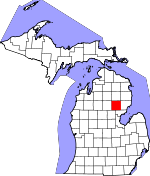
Ogemaw County, Michigan Basics:


Ogemaw County Michigan - Government Site

Population: 21,430
Area: 563 square miles
County seat: West Branch
Area code(s) in use: 989
Time zone: EST
High school graduate or higher: 84.6%
Bachelor's degree or higher: 10.8%
Median household income: $35,320
Persons in poverty: 20.5%
Home ownership rate: 83.1%
Mean travel time to work: 22.8 minutes


Adjacent counties:
Alcona  Arenac  Crawford  Gladwin  Iosco  Oscoda  Roscommon  

Find in Michigan

Map of the Ogemaw County area


Our detail map of Ogemaw County shows the Ogemaw County, Michigan boundary lines and other interesting items.

Places in Ogemaw County, Michigan

  Airports     show all on map

Boyer Airport, Junior North Heliport, Thompson Airport, West Branch Community Airport

  Buildings     show all on map

Clear Lake Volunteer Fire Department, Goodar Township Volunteer Fire Department, Lupton Fire Department, Michigan Department of Natural Resources West Branch Field Office, Mills Township Fire Department, Ogemaw County Courthouse, Ogemaw County Emergency Medical Services Authority, Ogemaw County Emergency Medical Services Authority Mills Township, Ogemaw County Emergency Medical Services Authority Rose City, Ogemaw County Historical Museum, Ogemaw County Sheriff's Office, Ogemaw District Library, Ogemaw East Library, Ogemaw Fire Department, Ogemaw Township Hall, Richland Logan Fire Department, Rose City Area Fire Department, Rose City City Hall, Rose City Police Department, Rose Township Hall, West Branch City Hall, West Branch Police Department, West Branch Public Library

  Cemeteries     show all on map

Beaver Lake Cemetery, Brookside Cemetery, Campbells Corners Cemetery, Churchill Township Cemetery, Damon Cemetery, Edwards Cemetery, Fisk Cemetery, Hill Township Cemetery, Lane Heights Cemetery, Logan Cemetery, Mills Cemetery, Oak Grove Cemetery, Ogemaw Springs Cemetery, Richland Cemetery, Rose Cemetery, Rose City Cemetery, Saint Joseph's Cemetery, Saint Josephs Cemetery, Tucker Cemetery

  Census     show all on map

Lupton Census Designated Place, Skidway Lake Census Designated Place

  Churches     show all on map

Beulah Mission, Beulah Mission, Bible Baptist Church, Calvary Baptist Church, Church of Christ, Church of God, Church of Jesus Christ of Latter Day Saints, Church of the Holy Fire, Church of the Nazarene, Churchill Church, Community of Christ Church, Edwards Church, Edwards Church, Faith Lutheran Church, First United Methodist Church, Free Methodist Church, Judson Baptist Church, Kingdom Hall of Jehovah's Witnesses, Logan Church, Lupton Friends Church, Mount Zion Tabernacle Church, New Hope Baptist Church, New Life Christian Church, Northwoods Baptist Church, Prescott Church, Prince of Peace Lutheran Church, Saint Andrews Episcopal Church, Saint John Lutheran Church, Saint Joseph's Church, Saint Josephs Church, Saint Stephens Church, Seventh Day Adventist Church, Skidway Lake Baptist Church, Trinity Episcopal Church, Trinity United Methodist Church, West Branch Assembly Church, Zion Church

  Crossings     show all on map

Interchange 212, Interchange 215

  Forests     show all on map

Ogemaw State Forest

  Hospitals     show all on map

Bortz Health Care - West Branch, Bortz Health Care of Rose City, Court Street Clinic, Evergreen Clinic, Main Street Family Practice Clinic, Prescott Clinic, Primary Care Practice Clinic, Sterling Area Health Center, West Branch Medical Clinic, West Branch Regional Medical Center

  Islands     show all on map

Happy Island, Middle Island, Zerons Island

  Lakes     show all on map

Ambrose Lake, Arrowhead Lake, Au Sable Lake, Bass Lake, Bass Lake, Beanshuttle Lakes, Bear Lake, Bear Lake, Beaver Lake, Big Norway Lake, Big Williams Lake, Birch Lake, Black Lake, Boss Lake, Boughner Lake, Bovee Lake, Bush Lake, Cabin Lake, Cedar Lake, Chandlers Lake, Chatman Lake, Clear Lake, Clear Lake, Cranberry Lake, Cranberry Lake, Crapo Lake, Cummings Lake, Cutting and Damon Lakes, Darlyn Lake, Deer Lake, Devils Washbasin, Devoe Lake, Dollar Lake, Doyle Lake, Eagle Lake, East Stylus Lake, Edwards Lake, Elbow Lake, Elni Lake, Engle Pond, Feeding Ground Lake, Fish Lake, Flowage Lake, Frost Lake, Gear Lake, George Lake, Grass Lake, Grass Lake, Grass Lake, Grebe Lake, Green Lake, Grousehaven Lake, Hardwood Lake, Harper Lake, Haskell Lake, Heintz Lake, Henderson Lake, Hewey Lake, Hidden Lake, Horseshoe Lake, Indian Lake, Island Lake, Jenkins Lake, Jewett Lake, Johnson Lake, King Lake, La Barge Lake, Laird Lake, Lake Augustina, Lake George, Lang Pond, Little Au Sable Lake, Little Cranberry Lake, Little Feeding Ground Lake, Little Frost Lake, Little Mud Lake, Little Norway Lake, Little Stylus Lake, Little Williams Lake, Lodge Lake, Long Lake, Long Lost Lake, Lost Lake, Lost Lake, Lost Lake, Mallard Pond, Middle Lake, Mills Lake, Mink Lake, Mud Lake, Mud Lake, Mud Lake, Mud Lake, Mud Lake, Mud Lake, Mud Lake, Mud Lake, Muleshoe Lake, Nero Lake, Nester Lake, No Mans Lake, North Dease Lake, Norway Lake, O'Connor Lake, Ogemaw Lake, Peach Lake, Pintail Pond, Piper Lake, Prior Lake, Prior Lake, Rat Lake, Redhead Lake, Rifle Lake, Rifle Lake, Rose Valley Pond, Sage Lake, Sandback Pond, Scaup Lake, Sidney Lake, Silver Lake, Silvis Lake, Skidway Lake, South Dease Lake, South Pond, Stylus Lake, Tee Lake, Thunder Lake, Townline Lake, Townline Lake, Trout Lake, Trout Lake, Turtle Lake, Twin Lakes, Valley Lake, Wallin Lake, Welles Lake, Withey Lake

  Locales     show all on map

Ambrose Lake State Forest Campground, Apple Valley Golf Course, Beaver Lake, Beaver Trails Campground, Bo - Te Farms, Cedar Lane Farms, Chief Okemus Camp, Circle K Farms, Convenant Cove Camp, Dale Farms, Edgewood Greens Golf Course, Emt Farms, Greenbriar Golf Course, Greenwood Station, Hardwood Lake Campground, Holiness Campground, Logan Corners, Loranger Station, Lost Valley Campgrounds, Lupton Station (historical), Maltby Station (historical), Mierson Farms, Ogemaw County Fairgrounds, Ogemaw Springs Station, Prescott Station (historical), Rifle River Camp, Rifle River Devoe Lake Rustic Campground, Rifle River Grousehaven Lake Campground, Rifle River Ranch Rustic Campground, Rifle River Spruce Rustic Campground, Rose City Station (historical), Rosebrugh Dairy Farm, Rowena Station (historical), South Branch Station (historical), Troll Landing Campground, West Branch Country Club, West Branch Rest Area, West Branch Station

  Oilfields     show all on map

Logan Gas Field, Rose City Oil Field, West Branch Oil Field

  Parks     show all on map

Big Fire Historical Marker, Cleveland Park Pavilion Historical Marker, Irons Park, Mills Township Newman Park, Rifle River State Recreation Area, Rose City Historical Marker, Rose Township District Number Five School Historical Marker

  Populated Places     show all on map

Camp Lu Lay Lea, Campbells Corners, Country Village Estates Mobile Home Park, Damon, Edwards, Elbow Lake, Fayettes Corner, Goodar, Greenwood, Lupton, Ogemaw Springs, Prescott, Rose City, Selkirk, Shady Shores, Skidway Lake, South Branch, Twin Pines Mobile Home Park, West Branch, West Branch Travel Trailer Park

  Post Offices     show all on map

Beaver Lake Post Office (historical), Campbells Corners Post Office (historical), Canfield Post Office (historical), Corrigan Post Office (historical), Damon Post Office (historical), Edward Post Office (historical), Goodar Post Office (historical), Greenwood Post Office (historical), Hardwoodlake Post Office (historical), Lupton Post Office, Maltby Post Office (historical), Nester Post Office (historical), Ogemaw Springs Post Office (historical), Piper Post Office (historical), Prescott Post Office, Rose City Post Office, Sage Post Office (historical), Selkirk Post Office (historical), Skidway Lake Post Office, Slayton Post Office (historical), South Branch Post Office, West Branch Post Office

  Reservoirs     show all on map

Lake Ogemaw

  Schools     show all on map

Baker College, East Side School, Harcourt School, Miller School, O'Neil School, Ogemaw Heights High School, Ogemaw Hills Christian School, Pleasant Hill School, Red School, Rifle River School, Rose City Elementary School, Saint Joseph West Branch School, Surline Elementary School, Whittemore-Prescott High School, Whittemore-Prescott Junior High School, Withey School

  Springs     show all on map

Geory Spring

  Streams     show all on map

Ammond Creek, Andrews Creek, Au Gres Creek, Au Sable Creek, Bailer Creek, Barber Creek, Bixby Creek, Brewery Creek, Brooks Creek, Campbell Creek, Clear Creek, Cooks Creek, Crane Creek, Crapo Creek, Dedrich Creek, Eddy Creek, Edwards Creek, Feeding Ground Creek, Gamble Creek, Grow Creek, Harper Creek, Harwood Creek, Hiltz Creek, Houghton Creek, Klacking Creek, Little Klacking Creek, Mansfield Creek, Mansfield Creek, Mattson Creek, Mayhue Creek, Mills Creek, Mink Creek, Mud Creek, Nester Creek, North Eddy Creek, Ogemaw Creek, Oyster Creek, Parren Creek, Peach Lake Creek, Perrys Creek, Peterson Creek, Prather Creek, Prior Creek, Rapid Creek, Ray Creek, Rifle Creek, Shepards Creek, Silver Creek, Simmons Creek, Skunk Creek, Smith Creek, South Branch Shepards Creek, South Eddy Creek, Spring Creek, Spring Creek, Vaughn Creek, West Branch Rifle River, Wilkins Creek, Woods Creek

  Summits     show all on map

Auger Hill, Cook Hills, Kuhn Hill, Pointers Hill, Preachers Hill, Tolfee Hill, Wagon Wheel Hill

  Swamps     show all on map

Alger Swamp, Dedrich Swamp, Foose Swamp, Harcourt Swamp, Maltbys Swamp, Ogemaw Swamp, Sidney Swamp, Tamarack Swamp

  Towers     show all on map

Rose City Lookout Tower, WBMB-AM (West Branch), WBMI-FM (West Branch),

Ogemaw County, Michigan Population By Race (2012 estimate)

RacePopulation
WhiteOgemaw County White population 20,78720,787  
MixedOgemaw County Mixed population 300300
American IndianOgemaw County American Indian population 171171
AsianOgemaw County Asian population 8685
BlackOgemaw County Black population 6464
Hawaiian & Pacific IslanderOgemaw County Hawaiian & Pacific Islander population 00

Additional population tables :
State population table
Michigan population by county