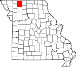
Harrison County, Missouri Basics:


Harrison County Missouri - Government Site

Population: 8,771
Area: 723 square miles
County seat: Bethany
Area code(s) in use: 660
Time zone: CST
High school graduate or higher: 85.5%
Bachelor's degree or higher: 9.2%
Median household income: $36,909
Persons in poverty: 14.1%
Home ownership rate: 74.2%
Mean travel time to work: 21.0 minutes


Adjacent counties:
Daviess  Decatur (IA)  Gentry  Grundy  Mercer  Ringgold (IA)  Worth  

Find in Missouri

Map of the Harrison County area


Our detail map of Harrison County shows the Harrison County, Missouri boundary lines and other interesting items.

Places in Harrison County, Missouri

  Airports     show all on map

Bethany Memorial Airport, Meadows Airport

  Buildings     show all on map

Akron Townhall, Bethany Fire Department, Cainsville Fire Protection District, Gilman City Fire Protection District, Harrison County Sheriff's Office, New Hampton Volunteer Fire Protection District, North Harrison County Fire Protection District, Ridgeway Rural Fire Department

  Cemeteries     show all on map

Akron Cemetery, Allen Cemetery, Andover Cemetery, Bohemian Cemetery, Brown Cemetery, Buntin Cemetery, Cat Creek Cemetery, Catholic Cemetery, Dale Cemetery, Downey Cemetery, Foster Cemetery, Gilman Cemetery, Grace Cemetery, Hughes Cemetery, Kidwell Cemetery, Lilly Cemetery, Lincoln Center Cemetery, Magee Cemetery, Miller Cemetery, Mitchell Cemetery, Mount Moriah Cemetery, Mount Olive Cemetery, Payne Cemetery, Phillebaum Cemetery, Pleasant Ridge Cemetery, Ridgeway Cemetery, Rose Hill Cemetery, Russ Cemetery, Springer Chapel Cemetery, Stoner Cemetery, White Oak Cemetery, Yankee Ridge Cemetery

  Churches     show all on map

Antioch Church, Bridgeport Church, Buckley Chapel, Fairview Church, Fairview Church (historical), Friendship Church (historical), Glaze Church (historical), Hazel Valley Church (historical), Hobbs Chapel, Kirkley Church, Lake Church (historical), Lone Rock Church, Matkins Church, Mitchell Church (historical), Mitchellville Church, Morris Chapel, Mount Olive Church (historical), Mount Olive Number Two Church (historical), Mount Pleasant Church, Mount Zion Church, New Harmony Church, New Hope Church, Oakland Church, Oland Church, Otterbem Church, Prairie Chapel, Shady Grove Church, Sharon Church, Springer Chapel, Union Chapel (historical), Union Chapel (historical), Union Church, Weaver Church, Wesley Church, White Oak Union Church (historical), Zion Church

  Dams     show all on map

Anderson Lake Dam, Arney Lake Dam, Baugher Dam, Baxter Lake Dam North, Baxter Lake Dam South, Bethany City Reservoir Dam, Bowles Lake Dam, Craig Lake Dam, Craig/Allen Dam Lt-90, D Buis B-11 Dam, East Fork Big Creek Dam A-30, East Fork Big Creek Dam A-34, East Fork Big Creek Watershed A-4 Dam, East Fork Big Creek Watershed Dam A-31, East Fork Big Creek Watershed Dam A-33, East Fork Big Creek Watershed Dam A-38, East Fork Big Creek Watershed Dam A-40, Fitz Farms Lake Dam, Fordyce Lake Dam, G Pitts E-10 Dam, H Taylor E-12 Dam, Hallock Lake Dam, Hamilton Lake Dam, Harcomo Lake Dam, Harcomo/Johnson Dam Lt-80, Hintz Lake Dam, Lake O' the Woods Dam, Landes Lake Dam, Landes-Stanley Lake Dam, Leazenby Lake Section 14 Dam, Leazenby Lake Section 15 Dam, Leonard Lake Dam, Linthacum Lake Dam North, Linthacum Lake Dam South, Marion Lake Dam, Meeks Dam, Miller Lake Dam, Mlika Lake Dam, Nelson Lake Dam, Panther Creek Watershed Dam A-1, Panther Creek Watershed Dam B-10, Panther Creek Watershed Dam B-13, Panther Creek Watershed Dam C-2, Panther Creek Watershed Dam D-1, Panther Creek Watershed Dam E-10, Panther Creek Watershed Dam E-12, Panther Creek Watershed Dam E-2, Panther Creek Watershed Dam F-10, Panther Creek Watershed Dam G-1, Panther Creek Wshd Dam E-1, Pelzer Lake Dam, Ratliff Lake Dam, Sittner Lake Dam, Stoner Lake Dam, Taylor Lake Dam South, Theusen Lake Dam, Tuggle Lake Dam, Tuggles Dam

  Forests     show all on map

Grand Trace State Forest

  Hospitals     show all on map

Harrison County Community Hospital

  Locales     show all on map

Bowman (historical), Fairview, Great Lakes Pumping Station, Harrison County Farm, Miracle Hills Ranch

  Parks     show all on map

Wayne Helton Memorial State Wildlife Area

  Populated Places     show all on map

Akron, Andover, Bethany, Blue Ridge, Blythedale, Bolton, Bridgeport, Brooklyn, Cainsville, Eagleville, Flint Hill, Gardner, Gilman City, Hatfield, Hermix, Lorraine, Martinsville, Matkins, Melbourne, Mitchellville, Mount Moriah, New Hampton, Pawnee, Pleasant Ridge, Ridgeway, Taylors Grove, Washington Center, Wildwood, Yankee Ridge

  Post Offices     show all on map

Bolton Post Office, Burr Oak Post Office, Cainsville Post Office, Cypress Post Office, Happy Valley Post Office, Harrison Post Office, Lampoon Creek Post Office, Oland Post Office, Taggart Post Office, Thomas Post Office

  Reservoirs     show all on map

Ally Lake, Anderson Lake, Baugher Lake, Bethany City Reservoir, Bethany New City Reservoir, Bethany Reservoir, Bethany Reservoir, Craig Lake, D Buis Lake, D Butin Lake, East Fork Big Creek Watershed Lake A-4, Fitz Farms Lake, Fordyce Lake, G Pitts Lake, G-1 Lake, Gibson Lake, Grants Lake, H Taylor Lake, Hallock Lake, Hamilton Lake, Harrison County Lake C-2, Harrison County Lake E-1, Hendren Lake, Hintz Lake, Jesse Hale Lake, K Camp Leazenby Lake, Lake O' the Woods, Landes Lake, Landes-Stanley Lake, Leonard Lake, Marion Lake, Meek Lake, Meinecke Lake, Nelson Lake, Pelzer Lake, Ratliff Lake, Reeder Lake, Rock House Lake, Savely Lake, Sittner Lake, Taylor Lake South, Tripp Lake, Tripp Lake

  Schools     show all on map

Akron School, Andover School, Arrington School, Banner School, Battle Creek School (historical), Belle School, Blue Ridge School, Bodam School (historical), Bolton School (historical), Bondurant School (historical), Brady School (historical), Brooklyn School (historical), Brown School (historical), Brush Oak School, Burton School, Bush School (historical), Cainsville Elementary School, Cainsville High School, Cisco School, Coates School (historical), Craiton School, Crause School (historical), Cypress School (historical), Donaby School (historical), Downey School, Eureka School (historical), Fairview School, Ford School (historical), Gilman City Elementary School, Gilman City High School, Glaze School, Globe School (historical), Green Castle School, Green Valley School (historical), Hagan School, Harmony School, Hazel Dell School (historical), Hickory Grove School (historical), Hickory School (historical), High Point School (historical), High Point School (historical), Hobbs School (historical), Hunt School, Jack Oak School, Liberty School (historical), Lickskillet School, Lincoln School (historical), Lone Rock School (historical), Lone Star School (historical), Long Branch School, Lorrain School (historical), Lynn School, Mahaska School, Maize School, Maple Grove School (historical), McCollum School (historical), Melbourne School, Metcalf School (historical), Mitchellville School (historical), Moore School (historical), Moore School (historical), Mount Pleasant School (historical), Mount Taber School (historical), Muddy Valley School (historical), Murphy School (historical), North Central Career Center, North Harrison Elementary School, North Harrison High School, North Pine School (historical), Nosseman School (historical), Oak Grove School, Pasture Hill School, Phoenix School, Piburn School (historical), Pilot Knob School (historical), Pin Oak School, Pine School, Pleasant Hill School (historical), Pleasant Ridge School, Pleasant Ridge School, Pleasant Valley School, Ramey School, Rice Town School (historical), Ridgeway Elementary School, Ridgeway High School, Rock Island School, Shady Dell School (historical), Sherman Center School (historical), Shiloh School (historical), Smith School (historical), Snowball School (historical), Solomon School (historical), South Harrison Elementary School, South Harrison Junior Senior High School, South Pine School (historical), Spring Hill School (historical), Star School, Stephen School, Surprise School (historical), Tull School, Turkey Grove School (historical), Union School (historical), Victor School, Victor School (historical), Walnut Grove School, Walnut Grove School (historical), Walnut School (historical), Washington Center School (historical), Washington School, White Fawn School, White Oak School (historical), Whiteoak School (historical), Wooderson School (historical), Woodland School (historical), Youngs School, Zimmerman School

  Streams     show all on map

Ames Branch, Barber Branch, Bracken Branch, Brush Creek, Brushy Creek, Buck Branch, Coal Creek, Crabapple Branch, Donaby Creek, East Fork Big Creek, East Fork Big Muddy Creek, Fleenor Branch, Flint Branch, Fox Creek, Indian Creek, Jefferies Creek, Latchel Branch, Little Creek, Little Creek, Little Panther Creek, Little Polecat Creek, Long Branch, Long Branch, Long Branch, Lost Creek, Martin Creek, Mosquito Creek, Panther Creek, Pecks Branch, Pointer Branch, Polecat Creek, Pony Branch, Poor Tom Branch, Queens Creek, Rocky Branch, Sandy Creek, Shain Creek, Stone Quarry Creek, Tombstone Creek, Trail Creek, West Fork Big Creek, West Fork Big Muddy Creek, West Fork Little Creek, West Fork Sampson Creek, White Oak Creek, Wolf Creek, Wolf Den Branch, Zadie Creek

  Towers     show all on map

KAAN-AM (Bethany), KAAN-FM (Bethany),

Harrison County, Missouri Population By Race (2012 estimate)

RacePopulation
WhiteHarrison County White population 8,5528,551  
MixedHarrison County Mixed population 9696
American IndianHarrison County American Indian population 4443
AsianHarrison County Asian population 3535
Hawaiian & Pacific IslanderHarrison County Hawaiian & Pacific Islander population 98

Additional population tables :
State population table
Missouri population by county