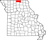
Putnam County, Missouri Basics:


Putnam County Missouri - Government Site

Population: 4,927
Area: 517 square miles
County seat: Unionville
Area code(s) in use: 660
Time zone: CST
High school graduate or higher: 83.5%
Bachelor's degree or higher: 14.3%
Median household income: $35,233
Persons in poverty: 19.4%
Home ownership rate: 74.8%
Mean travel time to work: 23.3 minutes


Adjacent counties:
Adair  Appanoose (IA)  Mercer  Schuyler  Sullivan  Wayne (IA)  

Find in Missouri

Map of the Putnam County area


Our detail map of Putnam County shows the Putnam County, Missouri boundary lines and other interesting items.

Places in Putnam County, Missouri

  Airports     show all on map

Municipal Airport, Unionville Municipal Airport

  Areas     show all on map

Chariton River Hills

  Buildings     show all on map

Elm Township Fire Protection District, Grant Township Fire District, Lemons Rural Volunteer Fire Department, Liberty Township Fire Protection District, Medicine Creek Township Fire Department, Missouri Department of Conservation Forestry Northeast Regional Field Fire Office Unionville, Putnam County Sheriff's Office, Unionville Police Department, Unionville Volunteer Fire Department, York Township Fire Department

  Cemeteries     show all on map

Anders Cemetery, Baptist Cemetery, Berry Cemetery, Bland Cemetery, Bratcher Cemetery, Bunker Cemetery, Busby Cemetery, Cain Ford Cemetery, Chapel Cemetery, Crumpacker Cemetery, Cullor Cemetery, Dean Cemetery, Dixon Cemetery, Dodson Cemetery, Friendship Cemetery, Hargrave Cemetery, Hatfield Cemetery, Haynes Cemetery, Hinerman Cemetery, Hogg Cemetery, Howard Cemetery, Hurley Cemetery, Husted Cemetery, Johnson Cemetery, Ledford Cemetery, Lemonville Cemetery, Lipp Cemetery, Lone Pine Cemetery, McCune Cemetery, Mendota Cemetery, Mitchell Cemetery, Old Busby Cemetery, Parsons Cemetery, Pherigo Cemetery, Pleasant Home Cemetery, Powersville Cemetery, Riggins Cemetery, Rose Cemetery, Saint John Cemetery, Shipley Cemetery, Shoney Cemetery, Speak Cemetery, Sprigg Cemetery, Summers Cemetery, Thompson Cemetery, Torrey Cemetery, Union Cemetery, Worthington Cemetery, Wyreka Cemetery, Young Cemetery

  Census     show all on map

Lemons Census Designated Place

  Churches     show all on map

Bethany Church, Christian Home Church, Faith Tabernacle, Hope Chapel (historical), Lowground Church, Mount Hermon Church, Mount Zion Church, Power of Prayer Church, Rehobeth Church, Stringtown Church, Union Church (historical), Union Grove Church, Wesley Chapel, West Concord Church, West Liberty Church

  Dams     show all on map

Cullor Lake Dam, Lake Mahoney Dam, Lake Thunderhead Dam, McCalments Dam, Phantom Lake Dam, Seaton Lake Dam, Unionville Old City Lake Dam

  Hospitals     show all on map

Putnam County Memorial Hospital

  Lakes     show all on map

Milton Lake

  Locales     show all on map

Bryant Station, Delpha (historical), Scotland Ridge, Slate Ford

  Populated Places     show all on map

Anderson (historical), Blackbird (historical), Central City, Chapel, Chariton, Clarksburg, Elko, Esper, Eureka, Galesburg, Glendale, Graysville, Hartford, Howland, Lemons, Lickskillet, Livonia, Lowground, Lucerne, Martinstown, Medicineville, Mendota, Midway, Omaha, Pearl City, Powersville, Putnamville, Quinn, Rosewood, Saint John, Shawneytown, Sidney, Terre Haute, Unionville, West Liberty (historical), Williamsburg, Worthington, Wyreka

  Post Offices     show all on map

Esper Post Office, Holbrook Post Office, Yuma Post Office

  Reservoirs     show all on map

City Lake, Lake McKinley, Lake Thunderhead, Lake Thunderhead, McCalments Lake, Phantom Lake, Unionville Reservoir

  Schools     show all on map

Abbott School (historical), Anders School (historical), Beary School (historical), Beatty School (historical), Berry School (historical), Blackbird School (historical), Bradshaw School (historical), Brasfield School, Brown School (historical), Buchannan School (historical), Burns School, Carr School (historical), Central City School, Clark School (historical), Cook School, Dorsett School, Douglas School, Douglas School (historical), East Dodson School (historical), Elm Branch School (historical), Fairview School (historical), Fife School (historical), Fillmore School (historical), Fowler School, Franklin School (historical), Friendship School (historical), Galesburg School (historical), Good Hope School, Good Hope School, Goodhope School, Grant School (historical), Gray School, Gray School, Graysville School (historical), Halley School, Hand School (historical), Hartford School (historical), Hatfield School (historical), Haynes School (historical), Hill Crest School (historical), Hill School (historical), Hogg School, Husted School (historical), Independent School (historical), Jones School (historical), Keene School (historical), King School (historical), Ledford School (historical), Liberty School, Lone Star School (historical), Loughead School (historical), Lowground School (historical), Mapleton School, McKay School (historical), McKinley School (historical), Means School (historical), Medicineville School (historical), Mendota School, Mount Vernon School (historical), Oak Grove School, Pearson School (historical), Petty School (historical), Pickering School, Saint John School (historical), Scott School (historical), Sells School (historical), Shoney School (historical), Snyder School (historical), Starr School, Stringtown School (historical), Terre Haute School (historical), Thornburg School (historical), Tinkham School (historical), Triumph School, Union School (historical), Vaughn School (historical), Victory School (historical), Waite School (historical), Wells School (historical), West Dodson School, West Liberty School (historical), West Putnam School, White School (historical), Wilkes School (historical), Wolfe School (historical), Wyreka School (historical)

  Streams     show all on map

Badger Branch, Baugh Branch, Brush Creek, Brush Creek, Buckworth Creek, Dog Branch, East Fork Medicine Creek, Elm Branch, Featherly Branch, Hackett Branch, Hylan Branch, Johnson Branch, Kinney Creek, Lick Branch, Lick Creek, Little Sandy Creek, Little Shoal Creek, Little West Locust Creek, Locust Creek, Logan Branch, Long Branch, Lost Creek, Middle Fork Medicine Creek, North Blackbird Creek, Sandy Creek, Shoal Creek, South Blackbird Creek, Tanyard Branch, Turkey Creek, Watkins Creek, West Fork Medicine Creek, West Locust Creek, Wildcat Creek, Williams Branch

  Trails     show all on map

Jones Spur,

Putnam County, Missouri Population By Race (2012 estimate)

RacePopulation
WhitePutnam County White population 4,8334,833  
MixedPutnam County Mixed population 4949
AsianPutnam County Asian population 2524
American IndianPutnam County American Indian population 109
Hawaiian & Pacific IslanderPutnam County Hawaiian & Pacific Islander population 00

Additional population tables :
State population table
Missouri population by county