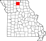
Sullivan County, Missouri Basics:
Sullivan County Missouri - Government Site
Population: 6,539
Area: 648 square miles
County seat: Milan
Area code(s) in use: 660
Time zone: CST
High school graduate or higher: 81.3%
Bachelor's degree or higher: 10.9%
Median household income: $34,247
Persons in poverty: 17.6%
Home ownership rate: 67.3%
Mean travel time to work: 17.4 minutes
Adjacent counties:
Adair Grundy Linn Mercer Putnam
Places in Sullivan County, Missouri
Cowgill-Roemer Airport,
Widmark Airport Green Castle Community Volunteer Fire Department,
Green City Fire Rescue,
Green City Rural Fire Department,
Harris Fire Department,
Medicine Creek Fire Protection District,
Milan Fire Department,
Milan Police Department,
Sullivan County Sheriff's Office,
Winigan Rural Fire Department Asbury Cemetery, Bairdstown Church Cemetery, Baldridge Cemetery,
Brackett Cemetery, Brookshier Cemetery,
Bunch Cemetery,
Burnett Cemetery,
Busby Cemetery,
Campbell Cemetery,
Deep Spring Cemetery, Embertson Cemetery,
Fields Cemetery,
Gilbert Cemetery,
Glaze Cemetery,
Green Castle Cemetery,
Green City Cemetery,
Greencastle Cemetery,
Haines Cemetery,
Haley Cemetery,
Hamilton Cemetery, Hannah Cemetery,
Harris Cemetery, Harrison Cemetery,
Hatcher Cemetery,
Hawkeye Cemetery, Head Cemetery,
Henry Cemetery,
Hickory Grove Cemetery,
Holiday Cemetery,
Hollon Cemetery,
Hoover Cemetery, Humphreys Cemetery,
Hurst Cemetery, Johnson Cemetery, Judson Cemetery,
Knifong Cemetery, Liberty Union Cemetery,
Lindley Cemetery,
Lovell Cemetery, Mairs Cemetery,
Marlay Cemetery, Marley Cemetery,
McCulla Cemetery, Miller Cemetery, Montgomery Cemetery, Montgomery Chapel Cemetery,
Mount Olive Cemetery,
Mount Olive Cemetery, Mount Olivet Cemetery, Mount Zion Cemetery,
Mount Zion Cemetery, Newtown Cemetery,
Oak Grove Cemetery, Oakwood Cemetery, Old City Cemetery,
Overstreet Cemetery, Owasco Cemetery,
Payne Cemetery,
Pickerel Cemetery, Plainview Cemetery,
Pleasantville Cemetery,
Pollock Cemetery, Reynolds Cemetery,
Schrock Cemetery,
Scobee Cemetery,
Shatto Cemetery, Shepherd Cemetery,
Springer Cemetery,
Tallman Cemetery,
Tunnell Cemetery,
Union Grove Cemetery,
White Oak Cemetery,
Wilhite Cemetery, Winigan Cemetery,
Wintersville Cemetery Winigan Census Designated Place Asbury Church,
Bairdstown Church,
Camp Ground Church,
Center Grove Church,
Elmwood Church,
Fairview Church,
Fairview Church,
Judson Church,
Liberty Union Church,
Locust Valley Church,
Mount Moriah Church,
Mount Zion Church,
Mount Zion Church,
Mount Zion Church,
Plainview Church,
Prairie Chapel,
Sullivan Church,
Thomas Union Church,
Union Baker Church,
Union Grove Church (historical),
White Oak Church,
Yellow Creek Church Baker Lake Dam,
Booth Lake Dam,
Brantner Lake Dam,
Carter Lake Dam,
Detwilder Lake Dam,
Dickson Lake Dam,
Eddys Lake Dam,
Elmwood City Lake Dam,
Fields Lake Dam,
Gray Lake Dam,
Green City Section 16 Dam,
Green City Section 18 Dam,
Humphreys Lake Dam,
Ischan Lake Dam,
Jones Dam,
K and W Farms Lake Dam,
Maher Lake Dam,
Meservey Lake Dam,
Milan Lake Dam - South Dam,
Milan Lake Dam-North Dam,
Pickering Lake Dam,
Rusk Lake Dam,
Sears Community Lake Dam,
Shatto Dam,
Strong and Stewart Lake Dam,
Taylor Lake Section 19 Dam,
Taylor Lake Section 24 Dam Sullivan County Memorial Hospital Opel (historical) Forest Grove Park Bairdston, Bowmansville,
Boynton,
Brown (historical),
Bute,
Cookman,
Cora, Elgin,
Green Castle,
Green City,
Harris,
Humphreys,
Jacksonville,
Judson,
Milan,
Mystic,
Newtown,
Osgood,
Owasco,
Parsons,
Paw Paw,
Pennville, Pleasantville,
Pollock,
Reger, Scottsville,
Sorrell,
Sticklerville, Sullivan City,
Winigan,
Wintersville Colfax Post Office,
Greencastle Post Office,
Opel Post Office (historical),
Sorrell Post Office Baker Lake,
Booth Lake,
City of Milan Lake,
Detwiller Lake,
Green City Large Reservoir,
Jones Lake,
Mononame 43 Lake,
New Milan Reservoir,
Number 41 Lake,
Number 44 Lake,
Sears Community Lake,
Shatto Lake,
Stevens Lake,
Strong and Stewart Lake Alexander School (historical),
Anspach School (historical),
Bairdstown School,
Beulah School (historical),
Black Oak School,
Boon Hill School (historical),
Boynton School (historical), Brookshier School,
Bundridge School (historical),
Center Grove School (historical),
Center Point School (historical),
Chaplin School (historical),
Chappell School (historical),
Cherry Grove School (historical),
Clear View School (historical),
Clem Springs School (historical),
Colfax School (historical),
Comstock School (historical),
Cook School (historical), Cora School,
Crossroads School (historical),
Dudley School (historical),
Duffield School (historical),
East Winigan School (historical),
Eggleston School (historical),
Elmwoods School (historical),
Enterprise School (historical),
Fairview School (historical),
Fairview School (historical),
Fairview School (historical),
Frazier School (historical),
Gilbert School (historical),
Gose School (historical),
Green Valley School (historical),
Griffith School (historical),
Hamilton School,
Harlan School (historical),
Hawkeye School (historical),
Hazel Ridge School (historical),
Hickory Grove School (historical),
Hickory Grove School (historical),
High Point School (historical),
Holliday School (historical),
Holly Hill School (historical),
Hook School (historical),
Independent School (historical),
Ivy Hill School (historical),
Jackson Corner School (historical),
Johnson School (historical),
Johnson School (historical),
Jones School (historical),
Judson School (historical),
Kiddville School (historical),
Knifong School (historical),
Knob School (historical),
Lee School (historical),
Liberty School,
Lone Star School (historical),
McClaskey School (historical),
Moggart School (historical),
Morris School (historical),
Mount Olive School (historical),
Mount Vernon School (historical),
North Bethel School (historical),
North Hooker School (historical),
Oak Grove School (historical),
Overstreet School (historical),
Owasco School (historical),
Payne School (historical),
Pennville School (historical),
Peterson School (historical),
Pine School (historical),
Pleasant Grove School (historical),
Pleasantville School (historical),
Prairie Dale School,
Prairie Flower School (historical),
Prairie Mound School (historical),
Red Brush School (historical),
Red School (historical),
Reed School (historical),
Rose Hill School (historical),
Ross School (historical),
Russell School,
Sandefur School (historical),
Scottsville School (historical),
Smith School (historical),
Springer School (historical),
Sterling School (historical),
Sunny Ridge School (historical), Tate School,
Terry School (historical),
Thompson School (historical),
Turner School (historical),
Victory School (historical),
Walnut Grove School (historical),
Warren School (historical),
Whaley School,
White Oak Grove School (historical),
Wilhite School (historical),
Wintersville School (historical),
Wolfe School (historical),
Wood School Barber Creek,
Bookout Branch,
Brushy Branch,
Dry Branch,
East Locust Creek,
Elmwood Branch,
Hooton Creek,
John Branch,
Little East Locust Creek,
North Spring Creek,
Paw Paw Creek,
Rooks Branch,
Spears Branch,

