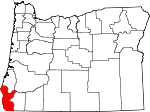
Curry County, Oregon Basics:


Curry County Oregon - Government Site

Population: 22,274
Area: 1627 square miles
County seat: Gold Beach
Area code(s) in use: 541
Time zone: PST
High school graduate or higher: 90.8%
Bachelor's degree or higher: 20.4%
Median household income: $38,401
Persons in poverty: 13.7%
Home ownership rate: 69.4%
Mean travel time to work: 14.0 minutes


Adjacent counties:
Coos  Del Norte (CA)  Douglas  Josephine  

Find in Oregon

Map of the Curry County area


Our detail map of Curry County shows the Curry County, Oregon boundary lines and other interesting items.

Places in Curry County, Oregon

  Airports     show all on map

Brookings Airport, Calvert Peak Airport, Cape Blanco State Airport, Crissey Airport (historical), Garvins Airfield, Gold Beach Municipal Airport, Winkle Bar Airport

  Arches     show all on map

Battle Rock Arch, Natural Bridges

  Areas     show all on map

Big Craggies Botanical Area, Big Prairie, Brush Prairie, Brushy Prairies, Carlton Prairie, Clay Hill Stillwater, Double Prairie, Eightmile Prairie, Guerin Prairie, Hilltop Prairie, Hooter Scooter Prairie, Jacks Prairie, Jackson Prairie, Johnson Prairie, Long Prairie, Mule Prairie, Sundown Prairie, Upper Mislatnah Prairie, Wagontire Prairie, Wilson Prairie

  Bars     show all on map

Agness Bar, Battle Bar, Blanco Reef, Blossom Bar, Brushy Bar, Canfield Bar, Chetco Bar, China Bar, Coyote Bar, Doyle Rock, Elephant Rock, Ferry Hole Bar, Foster Bar, Gardner Bar, Gleason Bar, Half Moon Bar, Kimball Bar, Lobster Bar, Lynch Bar, Mack Reef, Miller Bar, Missouri Bar, Orchard Bar, Orford Reef, Ostenbery Bar, Paradise Bar, Rogue River Reef, Solitude Bar, Taggarts Bar, Tituna Spit, Tom Fry Eddy, Walker Bar, Winkle Bar

  Basins     show all on map

Bonanza Basin, Elk Wallows, Gold Basin

  Bays     show all on map

Chetco Cove, Hunters Cove, Mack Arch Cove, Macklyn Cove, Nellies Cove, Seal Cove, Tichenor Cove

  Beaches     show all on map

Agate Beach, Agate Beach, Arizona Beach, Barley Beach, Harris Beach, Lone Ranch Beach, Ophir Beach, Sixes Beach, Wakeman Beach

  Bends     show all on map

Bacon Flat, Big Bend, Snag Patch

  Bridges     show all on map

Lobster Creek Bridge, Russell Bridge, Thomas Creek Bridge, White Elephant Bridge

  Buildings     show all on map

Agness Community Library District, Agness Illahee Fire Department, Brookings City Hall, Brookings Fire and Rescue, Brookings Municipal Court, Brookings Police Department, Brookings Public Works, Cal - Ore Life Flight Ground, Cape Blanco Lighthouse, Cape Blanco Lighthouse, Cape Ferrelo Rural Fire Protection District, Cedar Valley Fire Department, Chetco Community Public Library, Chetco Ranger Station, Chetco Valley Historical Museum, Curry County Courthouse, Curry County Public Health Department, Curry County Public Works, Curry County Sheriff's Office, Curry Historical Society Museum, Curry Public Library District, Department of Motor Vehicles Brookings, Gold Beach City Hall, Gold Beach Municipal Court, Gold Beach Police Department, Gold Beach Public Works, Gold Beach Volunteer Fire Department, Harbor Rural Fire Protection District, Historic Patrick Hughes House, Langlois Library District, Langlois Rural Fire Protection District, Ophir Rural Fire Department, Oregon State Police Department Gold Beach Worksite, Pelican Bay Lighthouse, Performing Arts Center and Community Theatre, Pistol River Rural Fire Protection District, Port Orford City Hall, Port Orford Community Ambulance, Port Orford Lifeboat Station Museum, Port Orford Municipal Court, Port Orford Police Department, Port Orford Public Library, Port Orford Public Works, Port Orford Volunteer Fire Department, Rogue Playhouse Theatre, Rogue River Siskiyou National Forest Law Enforcement Gold Beach Ranger District, Sixes Rural Fire Protection, United States Coast Guard Motor Lilfeboat Station Chetco River, United States Coast Guard Station Chetco River, Upper Chetco Rural Fire Protection District, Winchuck Rural Fire Protection District

  Capes     show all on map

Blacklock Point, Cape Blanco, Cape Ferrelo, Cape Sebastian, Chetco Point, Coal Point, Crook Point, Deer Point, Doyle Point, Fort Point, Graveyard Point, Mack Point, Nellies Point, Otter Point, Rocky Point, Seal Point, Tanbark Point, The Heads, Whalehead

  Cemeteries     show all on map

Buffington Memorial Park, Clay Hill Cemetery, Denmark Cemetery, Fox Hill Cemetery, Geisel Cemetery, Haines Cemetery, Huckleberry Knoll Cemetery, Hughes Family Cemetery, Illahe Cemetery, Merriam Cemetery, Mule Creek Cemetery, Oak Flats Cemetery, Ocean View Cemetery, Pioneer Cemetery, Pioneer Cemetery, Pistol River Cemetery, Rogue Cemetery, Rumley Hill Cemetery, Smith Family Cemetery, Tichenor Cemetery, Van Pelt Cemetery, Ward Memorial Cemetery

  Census     show all on map

Harbor Census Designated Place, Langlois Census Designated Place, Nesika Beach Census Designated Place, Pistol River Census Designated Place

  Channels     show all on map

Brewery Hole, Hells Gate, Johns Hole, Morrison Hole

  Churches     show all on map

Church of Jesus Christ of Latter Day Saints, First Community Church of Port Orford, Saint Charles Catholic Church, Saint Timothys Episcopal Church, Seventh Day Adventist Church, Zion Lutheran Church

  Cliffs     show all on map

Black Point, Inspiration Point, Rainbow Rock, Red Point, Squaw Bluff, Thomas Point, Thoms Point, Twin Sisters, Windy Point

  Dams     show all on map

Brookings Log Pond Dam, Ferry Creek Dam

  Falls     show all on map

Stair Creek Falls

  Flats     show all on map

Bark Shanty Prairie, Bear Pan Flat, Big Meadows, Calf Ranch Prairie, Fairview Meadow, Frantz Meadow, Gray Flat, High Prairie, Horse Prairie, Indigo Prairie, Lately Prairie, Looking-Glass Prairie, Northern Prairie, Oak Flat, Red Flat, Red Mountain Prairie, Rocky Prairie, Salt Lick Prairie, Skookumhouse Prairie, Snow Camp Meadow, Sourdough Flat, Steffin Meadow, Stump Prairie, Tent Prairie, Thompson Flat, Tucker Flat, Whitten Prairie, Wildhorse Prairie, Wilson Prairie, Yank Prairie

  Gaps     show all on map

Agness Pass, Anaktuvuk Saddle, Burnt Hill Summit, Chetco Pass, Doe Gap, Eagle Gap, Hells Gate, Tincup Pass

  Harbors     show all on map

Jot's Resort, Port of Brookings Harbor, Port Orford Harbor

  Hospitals     show all on map

Curry General Hospital

  Islands     show all on map

Arch Rock, Arch Rock, Arch Rock, Barnacle Rock, Battle Rock, Bell Rock, Best Rock, Black Rock, Black Rock, Black Rock, Brothers, Brown Rock, Burnt Rock, Camel Rock, Castle Rock, Cave Rock, Cluster, Conical White Rock, Couplets, Cousins, Diver Rock, Double Rock, Flat Black Rock, Flat Rock, Fountain Rock, Fox Rock, Goat Island, Green Rock, Guano Rock, Gull Rock, Gull Rocks, House Rock, Hump Rock, Hunters Island, Island Rock, Klooqueh Rock, Knox Rock, Large Brown Rock, Leaning Rock, Lone Rock, Long Brown Rock, Long Rock, Lookout Rock, Mack Arch, Mussel Rock, Needle Rock, Needles, North Rock, Northwest Rock, Northwest Rock, Pelican Rock, Pyramid Rock, Pyramid Rock, Rainbow Island, Red Rock, Redfish Rocks, Saddle Rock, Seal Rock, Sisters, Sisters Rocks, Southeast Black Rock, Square Rock, Square Rock, Square White Rock, Steamboat Rock, Table Rock, Tichenor Rock, Tower Rock, Twin Rocks, Twons, Walrus Rocks, West Conical Rock, Whalehead Island, White Rock, White Rock, Yellow Rock, Yellow Rock, Yellow Rock, Zwagg Island

  Lakes     show all on map

Allen Pool, Babyfoot Lake, Baldface Lake, Big Eddy, Chetco Lake, Euchre Creek Pond, Floras Lake, Foster Pond, Frog Lake, Frog Lake, Game Lake, Garrison Lake, Grass Lake, Laird Lake, Lake of the Woods, Lake of the Woods, Lish Lake, Little Vulcan Lake, Panther Lake, Salamander Lake, Smith Hole, Southard Lake, Valen Lake, Vulcan Lake

  Locales     show all on map

Agness Recreation Site, Alfred A Loeb State Park Boat Launch, Avery Ranch, Bailey Cabin, Bain Station, Barklow Mountain Campground, Battle Bar Recreation Area, Bear Camp Pasture Recreation Site, Bear Camp Viewpoint Recreation Site, Bear Wallow Lookout (historical), Blossom Bar Recreation Site, Bowman Ranch, Brandon Camp, Bravo Ranch (historical), Brookings Recreation Site, Brookings Wastewater Treatment Plant, Brookings Water Treatment Plant, Brushy Bar Recreation Site, Burt Camp, Butler Bar Recreation Site, Camp Fir Croft, Camp Hope, Camp Tacoma, Camp Victoria, Cape Blanco State Park Boat Ramp, Cedar Camp, Cedar Camp, Chetco (historical), Chetco Lookout (historical), Cleopatra Lookout (historical), Cold Springs Camp, Coldiron Camp, Conners Place, Corbin (historical), Cottonwood Camp, Cougar Lane Store Agness Landing, Curry County Fairgrounds Outdoor Stage, Curry County Outdoor Arena, Curry County Rodeo and Fairgrounds, Curry Public Transit Dispatch Facility, Dement Ranch, Ditch Creek Recreation Site, Doe Camp, East Creek Recreation Site, East Mule Recreation Site, Edson Creek Boat Ramp, Elk River Fish Hatchery Boat Ramp, Elk River State Fish Hatchery, Elko Camp Recreation Site, Emily Cabin, Ferry Hole Boat Ramp, First Camp Recreation Site, Fish Hook Camp (historical), Flora Dell Recreation Site, Fort Miner (historical), Fort Rowland (historical), Foster Bar Boat Launch, Foster Bar Recreation Site, Frankport, Fresno Camp, Fritsche Cabin, Fry Landing, Fry Place, Game Lake Lookout (historical), Game Lake Recreation Site, Gardner Ranch, Garrison Lake Boat Ramp, Gleason Bar Recreation Site, Gold Beach Boat Launch, Gold Beach Sewage Treatment Plant, Gold Beach Water Treatment Plant, Hare (historical), Hazel Camp, Hewitt Creek Recreation Site, Humboldt Spring Camp (historical), Huntly Park Boat Launch, Hurt Cabin, Ice Box Hole Boat Launch, Illahe Lodge, Illahe Recreation Site, Indian Creek Campground, Iron Head Boat Launch, Jacks Camp, Joe Hostler Camp, Jot's Resort Boat Ramp, Laird Lake Recreation Site, Langlois Water District, Limber Camp (historical), Little Redwood Recreation Site, Lobster Creek Boat Ramp, Lobster Creek Recreation Site, Long Gulch Recreation Area, Lucas Gravel Bar, Ludlum House Recreation Site, Ludlum Place, Madstone Cabin, Marial Lodge, McCurdy Campground, McFarlin (historical), McGribble Campground, McGribble Guard Station, McKee Cabin, Mid - Drift Boat Launch, Miller Bar Boat Launch, Miller Bar Recreation Site, Mislatnah Lookout (historical), Mountain Well Camp, Nook Bar Boat Launch, Nook Bar Recreation Site, Oak Flat Recreation Site, Okietown, Onion Camp, Ophir Safety Rest Area, Packers Cabin Group Camp, Packsaddle Lookout, Panther Creek Campground, Pickle Ranch, Port of Brookings Harbor Boat Ramp, Port of Brookings Harbor Boat Ramp North, Port of Gold Beach Boat Ramp, Port Orford Harbor Boat Hoist and Dock, Port Orford Harbor Boat Hoist and Dock, Port Orford Sewage Treatment Plant, Port Orford Water Treatment Plant, Quosatana Campground Boat Ramp, Quosatana Recreation Site, Rainbow Rock Service Association Sewage Treatment Facility, Redwood Bar Boat Launch, Redwood Bar Recreation Site, Rogue River Ranch, Shasta Costa Overlook, Sherman Ranch, Sixes River Store Boat Launch, Social Security Bar Boat Launch, Sourdough Camp, Sourdough Camp (historical), South Fork Boat Launch, South Fork Camp Recreation Site, Sport Haven Trailer Park Recreation Site, Squirrel Camp (historical), Sunshine Bar Recreation Site, Tale Creek Recreation Site, Tamba Ranch, Taylor Ranch, The Oaks, Thomas Creek Rest Area, Three Tree Lookout (historical), Toast Camp, Tolman Ranch, Tucker Flat Camp, Wedderburn Sanitary District Wastewater Treatment Plant, West Mule Recreation Site, Wildhorse Lookout, Wildhorse Recreation Site, Wilson Cabin, Winchuck Recreation Site

  Military     show all on map

Fort Lamerick (historical), Fort Orford (historical)

  Mines     show all on map

Babyfoot Mine, Blue Jay Mine, Bowser Mine, Cape Blanco Mine, Eagles Nest Mine, Gardner Mine, Golden Dreams Mine (historical), Golden Eagle Mine (historical), Hustis Mine (historical), Inman Mine, Little Siberia Mine, McKinley Mine, Old Red Mine, Pearsoll Mine, Peck Mine, Sunshine Mine, Uncle Sam Mine, Wests Mine

  Parks     show all on map

Alfred A Loeb State Park, Azalea City Park, Babyfoot Lake Area, Bankus Fountain, Battle Rock Wayside Park, Bud Cross Park, Buena Vista State Park, Cape Blanco State Park, Cape Sebastian State Park, Carpenterville Brookings Wayside (historical), Chetco Point Park, Collier H Buffington Memorial Park, Crissey Field State Park, Easy Manor Park, Edson Creek Campground, Fairview Camp, Floras Lake State Park, Geisel Monument State Park, Harris Beach State Park, Humbug Mountain State Park, Huntley Park, Illinois National Wild and Scenic River, Long Ridge Campground (historical), McVay Rock State Park, Oregon Islands National Wildlife Refuge, Otter Point State Park, Paradise Point State Park, Pine Point Picnic Ground, Pistol River State Park, Pocket Park, Port Orford Cedar Forest State Park, Port Orford Heads State Park, Richards Street Park, Rogue National Wild and Scenic River, Samuel H Boardman State Park, Sisters Rock State Park, Sixes River Recreation Site, South Beach Park, Stout Park, Three Tree Camp (historical), Tseriadum State Park, Waters Creek Campground (historical), Wheeler Creek Natural Research Area, Winchuck State Park

  Pillars     show all on map

Barrel Rock, Elephant Rock, Henry Rock, McVay Rock, Needle Rock, Pyramid Rock, Saddle Rock, Sawtooth Rock, Split Rock, Tide Rock, White Rock

  Populated Places     show all on map

Agness, Bagnell Ferry, Brookings, Carpenterville, Denmark, Eckley (historical), Gold Beach, Harbor, Hunter Creek, Illahe, Jerrys Flat (historical), Knoxville (historical), Lakeport (historical), Langlois, Marial, Nesika Beach, Ophir, Pistol River, Plum Trees, Port Orford, Sixes, Wedderburn

  Post Offices     show all on map

Agness Post Office, Bagnell Post Office (historical), Bennett Post Office (historical), Blaine Post Office (historical), Brookings Post Office, Carpenterville Post Office (historical), Chetco Post Office (historical), Corbin Post Office (historical), Cumtux Post Office (historical), Denmark Post Office (historical), Eckley Post Office (historical), Ekoms Post Office (historical), Elkridge Post Office (historical), Fern Post Office (historical), Ferry Post Office (historical), Gold Beach Post Office, Gray Post Office (historical), Harbor Post Office, Hare Post Office (historical), Illahe Post Office (historical), Irma Post Office (historical), Lakeport Post Office (historical), Langlois Post Office, Marial Post Office (historical), Moore Post Office (historical), Ophir Post Office, Pistol River Post Office, Port Orford Post Office, Quosation Post Office (historical), Ragic Post Office (historical), Sandstone Post Office (historical), Seaforth Post Office (historical), Sixes Post Office, Triangle Post Office (historical), Wedderburn Post Office, Winchuck Post Office (historical)

  Rapidss     show all on map

Auberry Riffle, Bacon Flat Riffle, Battle Bar Riffle, Bean Riffle, Bear Riffle, Big Boulder Rapids, Big Fish Riffle, Billings Rapids, Billings Rapids, Blossom Bar Rapids, Boiler Riffle, Brushy Bar Riffle, Burnt Rapids, Canfield Riffle, China Bar Rapids, Clay Hill Rapids, Coal Riffle, Coffeepot, Combs Riffle, Coyote Riffle, Crooked Riffle, Devils Stairs, Dunbar Riffle, Foster Rapids, Gillespie Riffle, Half Moon Riffle, Hawkins Riffle, Hayes Eddy, Horse Sign Creek Rapids, Hotel Riffle, Illahe Riffle, Island Rapids, Jennings Riffle, Jimmy Davis Riffle, Johns Riffle, Little Wildcat Rapids, Lobster Riffle, Long Gulch Riffle, Lower Shasta Costa Riffle, Lowery Riffle, Maggies Riffle, Mermaid Riffle, Milkmaid Riffle, Mixer Riffle, Nail Keg Riffle, Narrows, New Riffle, Old Diggins Riffle, Painted Riffle, Paradise Riffle, Payton Riffle, Quosatana Creek Riffle, Rachels Delight Riffle, Scow Riffle, Shasta Costa Riffle, Sherman Riffle, Shindler Riffle, Silver Creek Riffle, Slide Creek Riffle, Smith Riffle, Smithers Riffle, Solitude Riffle, Tacoma Rapids, Tichenor Riffle, Tom East Riffle, Twomile Rapids, Upper Coal Riffle, Upper Crooked Riffle, Wakeman Riffle, Walker Riffle, Watson Riffle, Wee Riffle, William Miller Riffle, Winkle Bar Riffle

  Reserves     show all on map

Grassy Knob Wilderness, Wild Rogue Wilderness

  Reservoirs     show all on map

Dads Lake, Evans Log Ponds, Ferguson Pond, Libby Creek Pond, Marsh Log Pond, Oregon Coast Log Pond, Pistol River Log Pond, Richman Reservoir, South Coast Log Pond

  Ridges     show all on map

Adams Prairie, Bald Ridge, Bear Camp Ridge, Bear Ridge, Boar Backbone, Burnt Ridge, Clay Hill, Devils Backbone, Devils Backbone, Devils Backbone, Fitzpatrick Ridge, Gardner Ridge, Long Ridge, Long Ridge, Moores Ridge, Oak Ridge, Panda Ridge, Panther Ridge, Peavine Ridge, Poverty Ridge, Short Ridge, Wheeler Ridge

  Schools     show all on map

Agness Elementary School, Azalea Middle School, Blanco School, Brookings Harbor Christian School, Brookings Harbor High School, Driftwood Elementary School, Gold Beach High School, Kalmiopsis Elementary School, Millard School (historical), Pacific High School, Riley Creek Elementary School, Upper Chetco Charter School

  Springs     show all on map

Alder Spring, Big Alder Spring, Cedar Springs, Cold Spring, Flycatcher Spring, Gold Basin Springs, Granite Spring, Humboldt Spring, Humboldt Spring, Huntley Spring, Limber Camp Spring, Mineral Spring, Robinson Spring, Salal Spring, Sulphur Spring

  Streams     show all on map

Abe Creek, Acorn Creek, Anderson Creek, Antone Creek, Anvil Creek, Arrastra Fork Mule Creek, Auberry Creek, Babyfoot Creek, Bagley Creek, Bald Mountain Creek, Baldface Creek, Basin Creek, Bea Creek, Bear Creek, Bear Creek, Bear Creek, Beartrap Creek, Beaver Creek, Bee Creek, Benson Creek, Big Creek, Big Redwood Creek, Big South Fork Hunter Creek, Bill Moore Creek, Billings Creek, Billys Creek, Biscuit Creek, Bishop Creek, Blackberry Creek, Blossom Bar Creek, Blue Jay Creek, Blue Slide Creek, Boulder Creek, Boulder Creek, Boulder Creek, Boulder Creek, Bowman Creek, Box Canyon Creek, Bradford Creek, Brandy Creek, Bravo Creek, Bridge Creek, Bridge Creek, Brokencot Creek, Bruces Bones Creek, Brush Creek, Brushy Bar Creek, Bull Creek, Bungalow Creek, Burns Creek, Burnt Hill Creek, Butler Creek, Butte Creek, Carey Creek, Carlton Creek, Carter Creek, Cedar Creek, Cedar Creek, Cedar Creek, Champman Creek, Chetco River, China Creek, Chrome Creek, Clay Hill Creek, Clear Creek, Cochran Creek, Cold Creek, Collier Creek, Conn Creek, Cooley Creek, Coon Creek, Coon Creek, Coon Creek, Copper Creek, Corral Creek, Craggie Creek, Crater Creek, Crook Creek, Crooked Bridge Creek, Crossen Creek, Crutchfield Creek, Crystal Creek, Cummins Creek, Cunniff Creek, Daniels Creek, Dans Creek, Darling Creek, Deadline Creek, Dean Creek, Deep Creek, Deer Creek, Ditch Creek, Ditch Creek, Dixie Creek, Doerr Creek, Dog Creek, Dostler Creek, Dry Creek, Dry Creek, Dry Creek, Dry Run Creek, Duley Creek, Duvall Creek, Dwyer Creek, Eagle Creek, Eagle Creek, East Creek, East Fork Cunniff Creek, East Fork Floras Creek, East Fork Hewitt Creek, East Fork Indigo Creek, East Fork Panther Creek, East Fork Pistol River, East Fork Winchuck River, Edson Creek, Edson Creek, Egans Creek, Eiler Creek, Elephant Rock Creek, Elk Creek, Elk Creek, Elk River, Elko Creek, Emily Creek, Ethels Creek, Euchre Creek, Fall Creek, Fall Creek, Fall Creek, Fall Creek, Fall Creek, Farmer Creek, Ferry Creek, First Creek, Fish Hook Creek, Flea Creek, Flood Creek, Flora Dell Creek, Floras Creek, Foster Creek, Foster Creek, Fourth of July Creek, Fox Creek, Fresno Creek, Gillman Creek, Glade Creek, Gold Run Creek, Granite Creek, Grant Creek, Grassy Creek, Greggs Creek, Guerin Creek, Hafner Creek, Haines Creek, Hamilton Creek, Hardtack Creek, Harris Creek, Hawk Creek, Hays Creek, Heather Creek, Henry Creek, Hewitt Creek, Hicks Creek, Hidden Creek, Hooskanaden Creek, Horner Creek, Horse Creek, Horse Prairie Creek, Horse Sign Creek, House Rock Creek, Hubbard Creek, Huff Creek, Hunter Creek, Illinois River, Indian Creek, Indian Creek, Indigo Creek, Iron Creek, Jack Creek, Jackson Creek, Jenny Creek, Jenny Creek, Jim Creek, Jim Hunt Creek, JoAnn Creek, Joe Cox Creek, Joe Hall Creek, Johnson Creek, Johnson Creek, Jordan Creek, Josh Creek, Kimball Creek, Kink Creek, Koch Creek, Koontz and Davis Creek, Krambeal Creek, Langlois Creek, Lawson Creek, Left Redwood Creek, Libby Creek, Lily B Creek, Little Chetco River, Little Dixie Creek, Little Dry Creek, Little Emily Creek, Little Silver Creek, Little South Fork Hunter Creek, Lobster Creek, Lone Ranch Creek, Lone Tree Creek, Lost Creek, Lost Valley Creek, Louise Creek, Lucky Creek, Lynch Creek, Macklyn Creek, Madden Creek, Madstone Creek, Marks Creek, Mayfield Creek, McCurdy Creek, McKinley Creek, McVay Creek, Meadow Creek, Mid Fork Panther Creek, Middle Fork Crystal Creek, Middle Fork Riley Creek, Middle Fork Sixes River, Milbury Creek, Mill Creek, Mill Creek, Mill Creek, Miller Creek, Miller Creek, Miller Creek, Miner Creek, Mineral Hill Fork, Mislatnah Creek, Missouri Creek, Moore Creek, Moores Creek, Morris Rodgers Creek, Morton Creek, Moser Creek, Mule Creek, Muleshoe Creek, Mussel Creek, Myers Creek, Myrtle Creek, Nail Keg Creek, Nancy Creek, Nell Creek, Nook Creek, Nook Creek, North Fork Chetco River, North Fork Collier Creek, North Fork Crystal Creek, North Fork Dry Creek, North Fork Elk River, North Fork Floras Creek, North Fork Foster Creek, North Fork Hubbard Creek, North Fork Hunter Creek, North Fork Indigo Creek, North Fork Lobster Creek, North Fork Myers Creek, North Fork Pistol River, North Fork Riley Creek, North Fork Sixes River, O'Brien Creek, Old House Creek, Otter Creek, Painted Rock Creek, Panther Creek, Panther Creek, Papoose Creek, Paradise Creek, Paradise Creek, Parker Creek, Patrick Creek, Pine Flat Creek, Pipeline Creek, Pistol River, Platinum Creek, Prairie Creek, Price Creek, Price Creek, Quail Creek, Quail Prairie Creek, Quosatana Creek, Rainbow Creek, Ram Creek, Ram Creek, Ransom Creek, Ransom Creek, Rattlesnake Creek, Red Cedar Creek, Red Mountain Creek, Reinhart Creek, Retz Creek, Rilea Creek, Riley Creek, Robinson Spring Creek, Rock Creek, Rock Creek, Rock Creek, Rocky Bar Creek, Rocky Creek, Rocky Point Creek, Rogue River, Russian Mike Creek, Rusty Creek, Salmon Creek, Sand Creek, Sankey Creek, Saunders Creek, Schoolhouse Creek, Scott Creek, Scott Creek, Scott Creek, Second Creek, Shasta Costa Creek, Shy Creek, Silver Butte Creek, Silver Creek, Sixes River, Sizeable Stream, Slide Creek, Slide Creek, Slide Creek, Slide Creek, Slide Creek, Slide Creek, Slide Creek, Slim Creek, Sluice Creek, Small Creek, Smith Creek, Snail Creek, Snout Creek, South Fork Bald Mountain Creek, South Fork Chetco River, South Fork Collier Creek, South Fork Elk River, South Fork Floras Creek, South Fork Lawson Creek, South Fork Lobster Creek, South Fork Pistol River, South Fork Riley Creek, South Fork Sixes River, South Fork Whalehead Creek, Spokane Creek, Spruce Creek, Squaw Creek, Squirrel Camp Creek, Stack Creek, Stair Creek, Stan Creek, State Creek, Stonehouse Creek, Sucker Creek, Sugar Creek, Sullivan Creek, Summers Creek, Sundown Creek, Sunrise Creek, Sunshine Creek, Tate Creek, Taylor Creek, Taylor Creek, Taylor Creek, Thomas Creek, Tincup Creek, Tolman Creek, Tom East Creek, Tom Fry Creek, Trout Creek, Turner Creek, Tuttle Creek, Twomile Creek, Venner Creek, Wake Up Rilea Creek, Walen Creek, Walker Creek, Waters Creek, Watson Creek, West Coon Creek, West Fork Clay Hill Creek, West Fork Cunniff Creek, West Fork Floras Creek, West Fork Indigo Creek, West Fork Mule Creek, West Fork Panther Creek, Whalehead Creek, Wheeler Creek, Whiskey Creek, White Rock Creek, Wildcat Creek, William Creek, William Miller Creek, Willow Creek, Willow Creek, Wilson Creek, Winchuck River, Windy Creek, Wridge Creek, Yorke Creek

  Summits     show all on map

Anvil Mountain, August Knob, Bailey Mountain, Bald Mountain, Barklow Mountain, Basin Butte, Big Craggies, Biscuit Hill, Black Mound, Bobs Garden Mountain, Bosley Butte, Brandy Peak, Brushy Bald Mountain, Brushy Mountain, Buckskin Peak, Bush Mound, Buzzard Roost, Buzzards Roost, Calf Ranch Mountain, Canfield Hill, Canyon Peak, Cashner Butte, Cassiday Butte, Cedar Point, Chetco Peak, China Mountain, China Peak, Chismore Butte, Coffee Butte, Colebrook Butte, Colegrove Butte, Collier Butte, Copper Mountain, Devils Half Acre, Dry Butte, Eagle Mountain, Edson Butte, Eightmile Prairie Mountain, Elk Mountain, Fairview Mountain, Fall Mountain, Father Mountain, First Prairie Mountain, Fish Hook Peak, Granite Butte, Grassy Knob, Green Craggie, Green Knob, Greenhill, Grizzly Mountain, Grouslous Mountain, Harris Butte, Hawks Rest, Hayward Peak, Heather Mountain, Hog Mountain, Horse Sign Butte, Hubbard Mound, Humbug Mountain, Indian Rock, Iron Mountain, Jacoby Butte, Johnson Butte, Kelsey Peak, Kimball Hill, Lake of the Woods Mountain, Lawson Butte, Little Edson Butte, Lobster Hill, Madden Butte, Milbury Mountain, Mineral Hill, Mislatnah Peak, Moon Mountain, Morton Butte, Morton Butte, Mount Avery, Mount Butler, Mount Emily, Mount Italy, Mule Mountain, Ophir Mountain, Packsaddle Mountain, Palmer Butte, Panther Mountain, Pearse Peak, Pebble Hill, Pine Point, Pinnacle Point, Pollywog Butte, Potato Illahe Mountain, Purple Mountain, Quail Prairie Mountain, Quosatana Butte, Racetrack Hill, Raspberry Mountain, Red Mound, Red Mountain, Red Rock, Ridge Knob, Rocky Peak, Round Top, Rumley Hill, Rusty Butte, Saddle Mountain, Saddle Peaks, Salmon Mountain, Sand Hill, Second Prairie Mountain, Sevenmile Peak, Signal Buttes, Silver Butte, Skookumhouse Butte, Smith Hill, Snaketooth Butte, Snow Camp Mountain, Soldier Camp Mountain, Squirrel Peak, Stack Yards, Star Mountain, Stone Butte, Sugarloaf Mountain, Sugarloaf Mountain, Sugarloaf Mountain, Summit Mountain, Sundown Mountain, Swede Heaven, Thomas Hill, Three Trees, Tincup Peak, Tomcat Hill, Ulmer Mountain, Vondergreen Hill, Vulcan Peak, Watches Butte, White Mountain

  Swamps     show all on map

Hunter Creek Bog

  Towers     show all on map

KURY-AM, KURY-FM

  Trails     show all on map

Bear Camp Trail, Bobs Garden Trail, Chetco Divide Trail, Chetco Peak Trail, Eagle Creek Trail, Elk Mountain Trail, Emily Creek Way, Grassy Knob Trail, Hazel Camp Trail, Lower River Trail, Mountain Wells Trail, Packsaddle Trail, Red Mountain Trail, Snaketooth Way, Snow Camp Trail, Upper Chetco Trail

  Valleys     show all on map

Bear Canyon, Bull Gulch, Butcher Gulch, Copper Canyon, County Line Canyon, Crew Canyon, Huggins Canyon, Little Canyon, Long Gulch, Long Hollow, Miner Gulch, Morrison Gulch, Mule Creek Canyon, Murphy Canyon, Pack Saddle Gulch, Pedro Gulch, Skookumhouse Canyon, Squaw Valley, Windy Valley

  Wells     show all on map

Mountain Well,

Curry County, Oregon Population By Race (2012 estimate)

RacePopulation
WhiteCurry County White population 20,75920,759  
MixedCurry County Mixed population 735735
American IndianCurry County American Indian population 490490
AsianCurry County Asian population 178178
BlackCurry County Black population 8989
Hawaiian & Pacific IslanderCurry County Hawaiian & Pacific Islander population 2222

Additional population tables :
State population table
Oregon population by county