Chester County, South Carolina Basics:


Chester County South Carolina - Government Site

Population: 32,615
Area: 581 square miles
County seat: Chester
Area code(s) in use: 803
Time zone: EST
High school graduate or higher: 77.4%
Bachelor's degree or higher: 11.1%
Median household income: $32,718
Persons in poverty: 24.0%
Home ownership rate: 76.3%
Mean travel time to work: 29.1 minutes

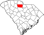
Adjacent counties:
Fairfield  Lancaster  Union  York  

Find in South Carolina

Map of the Chester County area


Our detail map of Chester County shows the Chester County, South Carolina boundary lines and other interesting items.

Places in Chester County, South Carolina

  Airports     show all on map

Chester Catawba Regional Airport

  Bridges     show all on map

Pedens Bridge

  Buildings     show all on map

Center for Retarded Children, Chester City Fire Department Station 2, Chester City Hall, Chester County Courthouse, Chester County Library, Chester County Rescue Squad, Chester Fire Department, Chester Police Department, Cross Roads Fire Department, Eureka Community House, Fishing Creek Power Plant, Fort Lawn Fire Department, Fort Lawn Police Department, Great Falls and Dearborn Power Plants, Great Falls Branch Chester County Library, Great Falls Fire Department, Great Falls Fire Department, Great Falls Police Department, Great Falls Rescue Squad, Lando Fire Department, Lando Fire Department Substation, Lando Fire Department Substation, Leeds Fire Department, Lewis Fire Department Lewis, Mount Zion Recreation Center, North Chester Fire Department, Richburg Fire Department, Richburg Fire Department Station 2, Rossville Fire Department, Rossville Fire Department Station 2, Rossvillle Community Center, South Carolina Highway Patrol Troop 4 Post C, South Chester Fire Department, South Chester Fire Department Station 2, West Chester Fire Department

  Canals     show all on map

Landsford Canal

  Cemeteries     show all on map

Anderson Cemetery, Ararat Cemetery, Benson Cemetery, Blackstock Cemetery, Blakles, Caldwells, and Strouds Cemetery, Browns-Strouds Cemetery, Brushy Fork Cemetery, Chester Memorial Gardens, Elmwood Cemetery, Evergreen Cemetery, Gold Mine Cemetery, Grant Cemetery, Guest Assembly Cemetery, Gunthorne Cemetery, Hopewell Cemetery, Howze Cemetery, Mount Hebron Cemetery, Mount Moriah Cemetery, Mount Moriah Cemetery, Mount Mpriah Cemetery, Mount Zion Cemetery, Old Purity Cemetery, Old Zion Cemetery, Stroud Cemetery, Sweet Hope Cemetery, Union Ezella Cemetery, William Martin Cemetery, Zion Cemetery

  Census     show all on map

Eureka Mill Census Designated Place, Gayle Mill Census Designated Place

  Churches     show all on map

Antioch Church, Ararat Church, Armenia Church, Armenia Church, Bethel Church, Bethel Church, Bethel United Methodist Church, Bethelehem Church (historical), Bethlehem Baptist Church, Bethlehem Church, Big Calvary Church, Black Rock Baptist Church, Blackstock Baptist Church, Blackstock Church, Blackstock Presbyterian Church, Brick Church (historical), Brooklyn African Methodist Episcopal Church, Browns Chapel, Calvary Baptist Church, Caper Chapel, Carmel Presbyterian Church, Cedar Grove Church, Cedar Rock Church, Cedar Shoals Church, Chester Associate Reformed Presbyterian Church, Chestnut Grove Church, Christian Home Church, Church of God, Church of God, Church of God, Church of Prophecy, Cornwell Church, Crossroads Church, Ebenezer Baptist Church, Ebenezer Church, Edgemoor Associate Reformed Presbyterian Church, Elbethel Church, Eureka Baptist Church, Eureka Church, Fairview Church, Faith Church, First Baptist Church, Fishing Creek Church, Friendship Church, Gethsemane Baptist Church, Gold Mine Church, Harmony Baptist Church, Heath Chapel, Hopewell Church, Hopewell Church, Landsford Church, Liberty Baptist Church, Lincolnville Church, Love-Charity Church, Lowrys Baptist Church, Metropolitan African Methodist Episcopal Church, Mizpah Presbyterian Church (historical), Mount Calvary Baptist Church, Mount Nebo Church, Mount Olive Baptist Church (historical), Mount Pleasant Church, Mount Pleasant Church, Mount Prospect Church, Mount Prospect Church, Mount Vernon Church, Mount Zion Church, Mount Zion Church, Mount Zion Church, New Hope Church, Oak Grove Church, Old Catholic Church, Old Wilson Church, Old Zion Baptist Church, Oliver Church (historical), Orrs Baptist Church, Parkway Baptist Church, Piney Grove Church, Piney Grove Church (historical), Pleasant Grove Church, Pleasant Grove Church, Pleasant Hill Church (historical), Pleasant View Church, Pryor Church (historical), Purity Presbyterian Church, Red Hill Church, Rehoboth Church, Rossville Church, Saint James Church, Saint Josephs Catholic Church, Saint Marks Episcopal Church, Saint Pauls Church, Saint Philips Church, Sanctified Church, Sandy River Church, Second Wilson Baptist Church, Sweet Hope Church, Trinity Church, Union Church, Union Church, Uriel Church, Well Ridge Church (historical), Westside Baptist Church, White Chapel (historical), Wilksburg Baptist Church, Williamsville Church, Woodward Baptist Church, Zion Church (historical), Zion Pilgrim Church, Zion Presbyterian Church

  Crossings     show all on map

Fishdam Ferry (historical), Fishdam Ford, Interchange 55, Interchange 62, Interchange 65, Johnson Ford, Lands Ford, Loves Ford, Lyles Ferry (historical), McDonalds Ford (historical), Thompson Ferry (historical), Woods Ferry (historical), Worthys Ferry (historical)

  Dams     show all on map

Atkinson Pond D-0228 Dam, Bolins Pond D-0229 Dam, Chester Reservoir Dam D-0207, Crisler Pond D-1438 Dam, Dearborn-Great Falls Dam, Fishing Creek Dam, Great Falls-Dearborn Dam, Logans Pond D-1439 Dam, Rocky Creek WCD Dam Number Eight D-0214, Rocky Creek WCD Dam Number Nine D-0215, Rocky Creek WCD Dam Number One D-0212, Rocky Creek WCD Dam Number Six D-0213, Rocky Creek-Cedar Creek Dam, Shepherds Pond D-1437 Dam, South Carolina Noname 12001 D-0206 Dam, South Carolina Noname 12003 D-0217 Dam, South Carolina Noname 12004 D-0208 Dam, South Carolina Noname 12005 D-0209 Dam, South Carolina Noname 12006 D-0210 Dam, South Carolina Noname 12011 D-0211 Dam, South Carolina Noname 12012 D-0223 Dam, South Carolina Noname 12013 D-0224 Dam, South Carolina Noname 12014 D-0225 Dam, South Carolina Noname 12021 D-0222 Dam, South Carolina Noname 12022 D-0227 Dam, South Carolina Noname 12023 D-0220 Dam, South Carolina Noname 12024 D-0219 Dam, South Carolina Noname 12025 D-0218 Dam, South Carolina Noname 12026 D-1436 Dam, South Carolina Noname 12027 D-0226 Dam, South Carolina Noname 23013 Dam, Tinkers Creek WCD Dam Number 21 D-0216

  Falls     show all on map

Great Falls of Catawba

  Hospitals     show all on map

Chester Regional Medical Center, Pryor Hospital (historical)

  Islands     show all on map

Big Island, Goat Island, Hill Island, Mountain Island, Pickett Island, Taylors Island (historical)

  Locales     show all on map

Allens Mill (historical), Chester Mall Shopping Center, Chester Plaza Shopping Center, Cotton Hills Farms, Counterman Farm, County Farm Industrial Park, Coyote Creek Farm, D and D Farms, Farrars Landing (historical), Hermit Hill Farm, Landsford Plantation, Leeds Campground, Leeds Rifle Range, Little Valley Ranch, Logan Farm, Miss Swiss Dairy, Momans Mill (historical), Peoples Plaza Shopping Center, Poolus Loop Hunt Camp, Republic Golf Course, Republic Mills, Saluda Square Shopping Center, Sloan Farms, Stephenson Farms, Stephensons Turkey Farm, Stevens Farms, Sunny Day Farm, Varnadores Store (historical), Wylie Mills

  Parks     show all on map

Chester County Fairgrounds, Chester Historic District, Chester State Park, Fish Dam Battleground Monument, Landsford Canal State Park, Woods Ferry Recreation Area, Wylie Park

  Populated Places     show all on map

Airlee, Armenia, Bascomville, Baton Rouge, Beckhamville, Binghamtown (historical), Blackstock, Brooklyn, Cabal, Caldwell Crossroad, Calvin (historical), Cedar Grove, Chester, Clarkson (historical), Cornwell, Dinber, Edgemoor, Eureka Mill, Eureka Mills, Evans, Forest Hills, Fort Lawn, Fudges (historical), Gayle Mill, Great Falls, Hicklin Crossing, Hilltop Acres, Knox, Lake View, Lakewood, Lando, Landsford, Leeds, Lewis, Lewisville (historical), Lowrys, McKeown, Mountain Lakes, Nitrolee, Orrs, Peden Oaks, Pineview Lakes, Quail Hollow, Richburg, Rodman, Rolling Hills Estates, Rossville, Rowell, Ruckers Crossroads, Sandy River, Smith, Springwood Lakes, Stringfellow, Tip Top (historical), Wellridge, Wilksburg, York Terrace

  Post Offices     show all on map

Chester Post Office, Fort Lawn Post Office

  Reservoirs     show all on map

Cedar Creek Reservoir, Chester Reservoir, Chester Reservoir, Chester State Park Lake, Dearborn-Great Falls, Fishing Creek Lake, Great Falls Reservoir, Great Falls-Dearborn Reservoir, Mountain Lakes, Mountain Lakes - Lower Lake, Mountain Lakes - Upper Lake, Rocky Creek-Cedar Creek Reservoir, Trollingwood Lake

  Schools     show all on map

Ararat School (historical), Armenia School (historical), Black Rock School (historical), Blackstock Academy (historical), Brainerd Institute (historical), Brick Academy (historical), Brockman School, Brooklyn School (historical), Capers Chapel School (historical), Cedar Grove School, Cedar Rock School (historical), Chester Christian School, Chester High School, Chester Male Academy (historical), Chesterville Academy (historical), Chesterville Female Seminary (historical), Chestnut Grove School, Christian Home School (historical), College Street School, Cross Roads School (historical), Dora Jones-Gayle Elementary School, Douglas School (historical), Edgemoor High School (historical), Elbethel School (historical), Eureka School (historical), Finley School, Fishing Creek School, Fishing Creek School (historical), Foote Street Elementary School (historical), Fort Lawn Elementary School, Gayle School, Goldmine School (historical), Great Falls Elementary School, Great Falls High School, Great Falls Middle School, Harmony School (historical), High Point School (historical), Hopewell School (historical), Jones School, Lando School, Landsford School (historical), Leeds School (historical), Lewisville Female Seminary (historical), Lewisville High School, Lowryville School (historical), Nero School (historical), North Chester School, Oakhill School (historical), Oakley Hall School, Pilgrim School, Piney Grove (historical), Pleasant Grove School, Pleasant Hill School (historical), Rossville School (historical), Russell Schhol (historical), Seeleys Creek School (historical), Southside School, Sunshine School (historical), Wellridge School (historical), West Chester School, Wilksburg Academy (historical), Wilksburg School (historical), Williams School, Witherow School (historical), York Road School

  Streams     show all on map

Barbers Creek, Bear Branch, Beaverdam Creek, Big Creek, Bond Branch, Brushy Fork Creek, Bull Run Creek, Bull Skin Creek, Caney Fork Creek, Carter Branch, Chapel Branch, Clarks Creek, Coon Creek, Dairy Branch, Dry Fork, Dunn Creek, Fishing Creek, George Branch, Grassy Run Branch, Gum Spring Branch, Hicklin Branch, Hodges Branch, Hooper Creek, Johns Creek, Julies Fork, Lipsy Spring Branch, Little Creek, Little Rocky Creek, Little Sandy River, Little Turkey Creek, Long Branch, McCluney Branch, McDaniel Branch, McFadden Branch, McKelvey Creek, Melton Branch, Mill Creek, Mineral Creek, Mobley Creek, Mountain Creek, Osborn Branch, Reaves Creek, Rock Branch, Rocky Branch, Rocky Creek, Rodens Creek, Rum Branch, Sandy River, Seeley Creek, Shannon Creek, Smith Creek, South Fork Fishing Creek, Starne Branch, Stover Creek, Susybole Creek, Tanyard Branch, Threemile Branch, Tinkers Creek, Turkey Branch, Turkey Creek, Twomile Branch, Walkers Mill Branch, Waters Branch

  Towers     show all on map

Chester Lookout Tower, Leeds Lookout Tower, WDZK-FM (Chester), WDZK-FM (Chester), WGCD-AM (Chester),

Chester County, South Carolina Population By Race (2012 estimate)

RacePopulation
WhiteChester County White population 19,60219,601  
BlackChester County Black population 12,23112,230
MixedChester County Mixed population 457456
American IndianChester County American Indian population 163163
AsianChester County Asian population 130130
Hawaiian & Pacific IslanderChester County Hawaiian & Pacific Islander population 00

Additional population tables :
State population table
South Carolina population by county