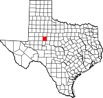
Mitchell County, Texas Basics:


Mitchell County Texas - Government Site

Population: 9,337
Area: 911 square miles
County seat: Colorado City
Area code(s) in use: 325
Time zone: CST
High school graduate or higher: 77.8%
Bachelor's degree or higher: 7.2%
Median household income: $41,082
Persons in poverty: 14.2%
Home ownership rate: 77.0%
Mean travel time to work: 22.8 minutes


Adjacent counties:
Borden  Coke  Fisher  Howard  Nolan  Scurry  Sterling  

Find in Texas

Map of the Mitchell County area


Our detail map of Mitchell County shows the Mitchell County, Texas boundary lines and other interesting items.

Places in Mitchell County, Texas

  Airports     show all on map

Colorado City Airport, Landers Ranch Airport, Trulock Ranch Field Airport

  Bends     show all on map

Cedar Bend, Horseshoe Bend

  Bridges     show all on map

Cedar Bend Bridge, Low Bridge

  Buildings     show all on map

Colorado City Civic Center, Colorado City Fire Department, Heart of West Texas Museum, Kristi Lee Manor, Mitchell County Ambulance Service, Mitchell County Courthouse, Mitchell County Jail, Mitchell County Public Library, Scott-Majors House, Texas Department of Criminal Justice Region 5 Daniel Webster Wallace Unit, Texas Department of Criminal Justice Region 5 Dick Ware Transfer Facility, Wallace Community Center, Westbrook Volunteer Fire Department

  Cemeteries     show all on map

Cemetery of the Sands, Colorado Cemetery, Handley Cemetery, Iatan Cemetery, McKenzie Cemetery, Mitchell County Cemetery, Spade Cemetery, Union Chapel Cemetery, Wallace Cemetery, Westbrook Cemetery, White Church Cemetery, Zion Rest Cemetery

  Census     show all on map

Lake Colorado City Census Designated Place

  Churches     show all on map

All Saints Episcopal Church, Bethel Primitive Baptist Church, Calvary Baptist Church, Christian Temple, Christian Temple (historical), Church of Christ, Church of Christ (historical), Dorn Church, Fairview Church, Faith Chapel, First Assembly of God, First Baptist Church, First Christian Church, First Presbyterian Church, First United Methodist Church, House of Hope Community Church, Iglesia de Cristo, Kingdom Hall of Jehovahs Witnesses, Mount Zion Baptist Church, Nathaniel Primitive Baptist Church (historical), New Life Bible Ministries, Northside Church, Oak Street Baptist Church, Payne Church, Plainview Church, Primera Iglesia Bautista el Calvario, Saint Anns Catholic Church, Saint James Baptist Church, Saint Luke Methodist Church, Templo Palabras de Vida (historical)

  Dams     show all on map

Butler Lake Dam, Champion Creek Dam, Colorado River Off Channel Storage Dam, Dockrey Tank Dam, Dunn Lake Dam, Ellwood Lake Dam, Gregory Lake Dam, Lake Colorado City Dam, Mitchell County Reservoir Dam, Red Dam, River Ranch Tank Dam, Spade Ranch Crane Hollow Tank Dam, Spade Ranch Hollywood Tank Dam, Tom Neff Lake Dam, White Dam

  Flats     show all on map

Shinnery Flats

  Hospitals     show all on map

Mitchell County Hospital

  Lakes     show all on map

Little Blue Hole

  Locales     show all on map

Butler Camp, Buzzard Windmill, Col-Tex Refinery (historical), Good Well Windmill, Jayhawk Windmill, Lucky Strike Windmill, Mud Spring Windmill, Oil Well Windmill, Rodet (historical), Spade Ranch, Spade Ranch, Twin Windmill, Wildcat Windmill, Wolf Creek Golf Course

  Oilfields     show all on map

Jameson Oil Field, Strain Pool Oil Field

  Parks     show all on map

Lake Colorado City State Park, Ruddick Park, Seven Wells Monument

  Populated Places     show all on map

Buford, Carr (historical), Colorado City, Cuthbert, Hyman, Iatan, Loraine, Lowe, Pecan Crossing, Spade, Valley View, Westbrook

  Post Offices     show all on map

Colorado City Post Office, Loraine Post Office

  Reservoirs     show all on map

Antelope Tank, Bailey Tank, Barber Lake, Barber Reservoir, Beals Creek Tank, Bert Tank, Bombsight Tank, Bozeman Tank, Buck Creek Tank, Bull Creek Tank, Bull Tank, Bullock Tank, Butler Lake, Calf Creek Tank, California Tank, Champion Creek Reservoir, Country Club Lake, Crane Hollow Tank, Dockrey Tank, Dunn Lake, Ellwood Lake, Five Hundred Pasture Tank, Five Section Tank, Forrest Lowe Tank, Four Section Tank, Geneva Tank, Gregory Lake, Hollywood Tank, Hyman Tank, John Tang Tank, Lake Colorado City, Lake Gregory, Limekin Tank, Little Renderbrook Tank, Little Water Tank, Logsdon Reservoir, Lower Renderbrook Tank, Lower Tank, Mason Tank, McGuire Tank, Meteor Tank, Mitchell County Reservoir, Northwest Antelope Tank, Northwest Boatright Tank, Rattlesnake Tank, Redbud Tank, River Ranch Tank, River Tank, Shinney Tank, Silver Tank, Six Tank, Southeast Bull Tank, Southwest Antelope Tank, Southwest Bull Tank, Tank Number Four, Tank Number Three, Tank Number Two, Tom Neff Lake, Upper Tank, Usg Number One Tank, Van Zandt Tanks, Vowell Tank, Walnut Creek Tank, Watson Tank, Wheat Pasture Tank, Wildcat Tank, Willow Tank, Willow Tank

  Schools     show all on map

Baumann School, Carr School, Colorado City Middle School, Colorado High School, Conaway School, Dorn School, Hobbs Alternative Education Center - Colorado, Hobbs Alternative Education Center - Loraine, Horns Chapel School, Hutchinson Elementary School, Kelley Elementary School, Longfellow School (historical), Looney School, Loraine School, Rogers School, Seven Wells School (historical), Wallace School (historical), Westbrook School

  Springs     show all on map

McGuire Spring, Renderbrook Spring

  Streams     show all on map

Antelope Creek, Beals Creek, Big Silver Creek, Brushy Creek, Buck Creek, Bull Creek, Camp Creek, Champion Creek, Deep Creek, Dry Hollow Creek, Forest Creek, Geneva Creek, Granger Creek, Graze Creek, Hackberry Creek, Hasting Creek, Iatan Creek, Jayhawk Creek, Little Silver Creek, Little Water Creek, Little Willow Creek, Lone Wolf Creek, Morgan Creek, Mustang Creek, North Branch Hasting Creek, North Fork Champion Creek, Red Bank Creek, Renderbrook Creek, Sandy Creek, South Fork Champion Creek, Walnut Creek, Wildcat Creek, Wildhorse Creek, Willow Creek, Willow Creek

  Summits     show all on map

Beals Mountain, Clay Smith Peak, Hayrick Mountain, Lone Wolf Mountain, Morgan Peak, Rattlesnake Mountain, Red Hills, Stepp Mountain

  Towers     show all on map

KAUM-FM (Colorado City), KVMC-AM (Colorado City)

  Trails     show all on map

Lake Colorado City State Park Trail

  Valleys     show all on map

Badgett Canyon, Bone Hollow, Buffalo Draw, Bullock Canyon, Cedar Canyon, Dam Draw, Dawson Canyon, Hanks Hollow, McGuire Canyon, Moser Canyon, North Fork Canyon, Rabbit Hollow, Red Draw

  Wells     show all on map

Calf Pasture Well,

Mitchell County, Texas Population By Race (2012 estimate)

RacePopulation
WhiteMitchell County White population 7,8157,815  
BlackMitchell County Black population 1,1951,195
MixedMitchell County Mixed population 131130
AsianMitchell County Asian population 5656
Hawaiian & Pacific IslanderMitchell County Hawaiian & Pacific Islander population 00

Additional population tables :
State population table
Texas population by county