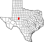
Sterling County, Texas Basics:


Sterling County Texas - Government Site

Population: 1,183
Area: 923 square miles
County seat: Sterling City
Area code(s) in use: 325
Time zone: CST
High school graduate or higher: 79.4%
Bachelor's degree or higher: 20.8%
Median household income: $44,239
Persons in poverty: 15.2%
Home ownership rate: 71.1%
Mean travel time to work: 18.1 minutes


Adjacent counties:
Coke  Glasscock  Howard  Mitchell  Reagan  Tom Green  

Find in Texas

Map of the Sterling County area


Our detail map of Sterling County shows the Sterling County, Texas boundary lines and other interesting items.

Places in Sterling County, Texas

  Airports     show all on map

Alvie Cole Ranch Airport, Mc Entire's Lazy V Ranch Airport, V and J Ranch Airport

  Buildings     show all on map

Sterling County Emergency Medical Services, Sterling County Fire Department, Sterling County Public Library

  Cemeteries     show all on map

Edwards Cemetery, Foster Cemetery, Lolanthe Cemetery, Montvale Cemetery

  Cliffs     show all on map

Crawford Slide

  Dams     show all on map

W H Reed Dam

  Gaps     show all on map

The Gap

  Lakes     show all on map

Rockwater Hole

  Locales     show all on map

Alvie Cole Ranch, Bobs Creek Ranch, Boone Windmill, Bull Pasture Windmill, Cedar Windmill, Challenge Windmill, Cole Ranch, Coleman Windmill, Davis Windmill, Dempster Windmill, Divide Windmill, Doodle Bug Windmill, East Windmill, Finley Windmill, Foster Ranch, Garden Windmill, Garrett Windmill, Glass Ranch, Happy Windmill, McClure Ranch, McEntire Ranch, McGill Ranch, Model A Windmill, Monitor Windmill, North Windmill, Patsy Windmill, Perry Windmill, Phillip Windmill, Powell Sheep Camp, Reed Ranch, Reed Ranch, Santa Fe Ranch, Shack Ranch, Wilson Pasture Windmill

  Oilfields     show all on map

Clark Oil Field, Durham Oil Field, Herrell Oil Field, Parochial Bade Oil Field

  Populated Places     show all on map

Broome, Camp Elizabeth (historical), Iolanthe (historical), Sterling City

  Post Offices     show all on map

Sterling City Post Office

  Reservoirs     show all on map

Big Red Tank, Buck Tank, Caliche Tank, Catclaw Tank, Cedar Tank, Corral Tank, County Line Tank, Double Tank, Double Tanks, East Trap Tank, Gasconades Tank, Harvey Martin Tank, Horse Pasture Tank, Jackson Tank, John W Tank, McWhorter Mountain Tank, Middle Seamen Tank, Middle Tank, Mountain Tank, New Boatright Tank, New McWhorter Tank, North Tank, Northeast Boatright Tank, Northeast Seamen Tank, Northwest McWhorter Tank, Northwest Seamen Tank, Old Boatright Tank, Old McWhorter Tank, Powell Tank, Snake Mountain Tank, Southeast Antelope Tank, Southwest Peter Lake Tank, Spring Tank, W H Reed Reservoir, Willow Net Tank

  Schools     show all on map

Sterling City Elementary School, Sterling City High School, Sterling City Junior High School

  Streams     show all on map

Bobs Creek, Chalk Creek, Dobson Creek, Heifer Creek, Lacy Creek, Little Bobs Creek, Little Mulberry Creek, North Gasconades Creek, South Gasconades Creek, Sterling Creek, Willow Creek

  Summits     show all on map

McWhorter Mountain, Round Top, Snake Mountain

  Valleys     show all on map

Bodcaw Draw, China Draw, Cobb Draw, Cox Hollow, Cumbie Draw, Dobson Draw, Dripping Springs Draw, Gardener Draw, Hay Hollow, James Hollow, Mackenzie Draw, Pierce Canyon, Sand Bluff Draw, Westfall Draw

  Wells     show all on map

Elliott Well,

Sterling County, Texas Population By Race (2012 estimate)

RacePopulation
WhiteSterling County White population 1,1191,119  
American IndianSterling County American Indian population 2222
MixedSterling County Mixed population 2020
BlackSterling County Black population 1817
AsianSterling County Asian population 22
Hawaiian & Pacific IslanderSterling County Hawaiian & Pacific Islander population 11

Additional population tables :
State population table
Texas population by county