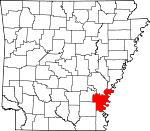
Desha County, Arkansas Basics:


Desha County Arkansas - Government Site

Population: 12,566
Area: 768 square miles
County seat: Arkansas City
Area code(s) in use: 870
Time zone: CST
High school graduate or higher: 75.7%
Bachelor's degree or higher: 12.8%
Median household income: $29,504
Persons in poverty: 28.4%
Home ownership rate: 56.6%
Mean travel time to work: 22.4 minutes


Adjacent counties:
Arkansas  Bolivar (MS)  Chicot  Drew  Lincoln  Phillips  
Find in Arkansas

Map of the Desha County area


Our detail map of Desha County shows the Desha County, Arkansas boundary lines and other interesting items.

Places in Desha County, Arkansas

  Airports     show all on map

Billy Free Municipal Airport, Flying G Ranch Airport, Mayer Airport, Mc Gehee Municipal Airport, McGehee Desha County Hospital Heliport, Pickens Airport, Reedville Airport, Shiloh Landing Strip, Yancopin Airport

  Areas     show all on map

Caulk Neck, Laconia Circle

  Bars     show all on map

Henrico Bar, Melinda Bar, The Bar

  Bays     show all on map

Knowlton Crevasse, Laconia Crevasse, Paradise Bay

  Bends     show all on map

Birmingham Bend, Bolivar Bend, Caulk Cut-off, Concordia Bend (historical), Jackson Bend, Jefferson Bend, Montgomery Bend, Raddish Bend, Rosedale Bend, Scrubgrass Bend, Slide Off Bend, Victoria Bend

  Buildings     show all on map

Arkansas City Fire Department, Arkansas City Police Department, Desha County Courthouse, Desha County Museum, Desha County Sheriff's Office, Dumas Emergency Medical Services, Dumas Fire Department, Dumas Nursing Center, Dumas Police Department, Dumas Public Library, Halley Volunteer Fire Department, Kelso Rohwer Fire Department, McGehee Fire Department, McGehee Fire Department Ambulance, McGehee Fire Department Station 2, McGehee Police Department, Mitchellville Fire Department, Mitchellville Police Department, Potlatch Corporation Ambulance, Reed Police Department, Reed Volunteer Fire Department, Southeast Arkansas Law Enforcement Center - Desha County Sheriff Substation, Southeast Arkansas Law Enforcement Center Highway Patrol Station, Southeast Arkansas Law Enforcement Center- Alcohol Tobacco And Firearms, Southeast Arkansas Law Enforcement Center- State Police Troop E, Watson Volunteer Fire Department Station 1, Watson Volunteer Fire Station 2

  Canals     show all on map

Canal Number 16, Canal Number 18, Canal Number 19, Canal Number 2, Canal Number 43, Canal Number 66, Canal Number 67, Canal Number 81, Mills Bayou Ditch

  Capes     show all on map

Cat Island, Caulk Point, Island Number 73, Montgomery Point, Wells Point

  Cemeteries     show all on map

Banks Cemetery, Barnett Cemetery, Bates Cemetery, Beasley Cemetery, Bogue Cemetery, Bogue Pilgrim Cemetery, Bowie Cemetery, Curtis Hall Cemetery, Gentry Cemetery, Gum Grove Cemetery, Henrico Cemetery, Holly Grove Cemetery, Hopkins Cemetery, Irby Cemetery, Jefferson Cemetery, Jerusalem Cemetery, Jones Cemetery, Kelso Cemetery, Leach Cemetery, Luke Cemetery, McArthur Cemetery, McCool Cemetery, Memorial Cemetery, Morgan Cemetery, Mound Cemetery, New Hope Cemetery, Newton Cemetery, Palestine Cemetery, Porter Cemetery, Rohwer Relocation Center Cemetery, Rolling Water Cemetery, Saint Paul Cemetery, Scott Cemetery, Seven Star Cemetery, Thompsons Cemetery, Turner Cemetery, Walnut Lake Cemetery, Warrington Cemetery, White Parker Cemetery

  Channels     show all on map

Montgomery Cutoff, Napoleon Cutoff, Saw Mill Bend Cutoff, Whiskey Chute

  Churches     show all on map

Almetta Church, Amos Bayou Church, Arkansas City Baptist Church, Bethel Church, Bethlehem Church, Bogue Church, Bogue Pilgrim Church, Bowie Church, Calvary Missionary Baptist Church, Chickasaw Baptist Church, Church of God, Claiborne Chapel, Daniel Chapel Baptist Church, Dumas Church of Christ, First Assembly of God Church, First Baptist Church, First Baptist Church of Dumas, First Delta Church, First United Methodist Church, Havis Chapel, Holy Child Catholic Church, Hopedale Church, Jerusalem Church, Lightwood Church, Little Zion Church, Macedonia Church, McArthurs Friends Church, Morning Star Church, Mount Olive Church, Mount Olive Church, Mount Olive Church, Mount Pleasant Church, Mount Table Church, Mount Zion Church, Mount Zion Church, Mount Zion Church, New Bethel Church, New Canaan Church, New Hope Church, New Hope Church, New Light Church, New Salem Church, Newton Chapel, Northside Baptist Church, Oak Grove Church, Oems Free Gift Church, Orange Chapel, Palestine Church, Pleasant Valley Church, Providence Church, Rankin Chapel Baptist Church, Richland Baptist Church, Saint Andrew Church, Saint John Church, Saint Lake Church, Saint Marys Church, Saint Pauls Church, Saint Stevens Church, Serene Church, Seven Star Church, Sims Chapel, Snow Lake Baptist Church, True Vine Church, Union Chapel, United Pentecostal Church, Walnut Grove Church (historical), West Dumas Church of God in Christ, Williamson Chapel, Zion Chapel

  Dams     show all on map

Frenchie Lake Dam, Walnut Lake Dam

  Flats     show all on map

Big Island, Brushy Lakebed, Snow Lakebed, Tarblue Lakebed

  Guts     show all on map

Bear Slough, Big Slough, Black Pond Slough, Boggy Bayou, Carter Bayou, Carter Slough, Cessions Towhead Chute, Chicot Bayou, Chute of Island 69, Clay Bayou, Coon Bayou, Crazy Bayou, Cypress Bayou, Dry Bayou, Dry Bayou, Dry Slough, Eugene Bayou, Hobson Chute, Hogpen Slough, Horsehead Slough, Johns Bayou, Knowlton Bayou, Little Bayou Macon, Little Boggy Bayou, Middle Coon Bayou, Mills Bayou, Mud Slough, Old Indian Bayou, Outer Chute, Prices Bayou, Sanders Lake Bayou, Sandy Bayou, Sixmile Bayou, Wells Bayou, Zellner Brake

  Hospitals     show all on map

Delta Memorial Hospital, McGehee - Desha County Hospital

  Islands     show all on map

Beulah Island Number 74, Caulk Island, Cessions Towhead, Choctaw Bar Island, Choctaw Island Number 78, Chute of Island Number 73, Goat Island, Island Number 69, Island Number 71, Montgomery Island, Montgomery Towhead, Mud Island

  Lakes     show all on map

Alligator Lake, Amos Bayou, Bar Lake, Bar Lake, Bear Lake, Bear Lake (historical), Belcoe Lake, Big Round Lake, Billy Moore Lake, Blue Hole, Blue Hole, Blue Hole, Blue Hole, Bobs Blue Hole, Bobtail Lake, Callie Lake, Clear Lake, Deep Lake, Double Cabin Lake, Dry Bayou, Eagles Nest Lake, East Moon Lake, Echubby Lake, Elbow Lakes, Fishing Bayou Waterhole, Graddy Blue Hole, Grindle Hole, Half Moon Lake, Hog Pen Hole, Hole in the Wall Lake, Jefferson Lake, Kate Adams Lake, Lake Beulah, Lake Cheatham, Lake Defiance, Lake Isaacs, Lake Lenox, Lake Lenox, Lake Whittington, Little Clear Lake, Little Goose Lake, Little Jefferson Lake, Long Lake, Long Lake, Lower Parish Lake, Lower Swan Lake, Minnie Anderson Old River, Mixture Lake, Moon Lake, Mossy Lake, Mound Lake, Mud Lake, Oxbow Lake, Oxbow Lake, Ozark Lake, Paradise Bayou, Parish Lake, Pelican Lake, Pothole Lake, Prairie Lakes, Prices Lake, Red Fork Lake, Rosemary Lake (historical), Silver Lake, Smith Lake, Snow Lake (historical), Swan Lake, Swan Lake, Swan Lake, Swan Lake, Tarblue Lake (historical), Timber Lake, Upper Old River Lake, Walnut Lake, Webfoot Lake, Whisky Lake, Whitehill Lake

  Levees     show all on map

Arkansas City Yellow Bend Revetment, Below Knowlton Dikes, Big Island Revetment, Cessions Towhead Revetment, Cypress Bend Revetment, Henrico Dikes, Henrico Revetment, Knowlton Revetment, Laconia Circle Levee, Montgomery Towhead Dikes, Pair O' Dice Revetment, Scrubgrass Bend Revetment, White River Landing Dikes

  Locales     show all on map

Beith Landing, Brookhaven Shopping Center, Carter Shopping Center, Caulk Landing (historical), Chicot Landing (historical), Cooks Ramp, Delta Country Club, DeSoto Landing, Holly Ridge Landing, Hopedale Landing, Knowlton Landing, Laconia Landing, McCloud Landing, Napoleon Landing, O'Neal Landing, Ozark Landing, Pendleton Ferry, Rohwer War Relocation Center (historical), Rose Landing, Rosemary Landing (historical), Scrubgrass Campground, White River Landing

  Parks     show all on map

Memorial Park, Morgan Point Recreation Area, Pendleton Recreation Area, Stephens Park, Wiley A McGehee Park

  Populated Places     show all on map

Arkansas City, Back Gate, Beulah Island Landing, Bogota (historical), Choctaw Village (historical), Deerfield, Duce, Dumas, Halley, Henrico (historical), Hopedale (historical), Jersey Point, Kelso, Knowlton, Kurdo (historical), Laconia, Lacy (historical), Littles (historical), Lorays, Lucca Landing, Masonville, McArthur, McGehee, Medford (historical), Mitchellville, Mozart, Oaklawn, Omega, Parma (historical), Pea Ridge, Pendleton, Pickens, Red Fork, Reed, Reedville, Rohwer, Rotan, Snow Lake, Stimson, Trippe Junction, Wargo Landing, Watson, White River, Yancopin, Yukon, Zellner (historical)

  Post Offices     show all on map

Dumas Post Office

  Reservoirs     show all on map

Frenchie Lake

  Schools     show all on map

Arkansas City Elementary School, Arkansas City High School, B C Prewitt Elementary School, Bogue Pilgrim School, Central Elementary School, Delta Elementary School, Delta High School, Desha Central High School, Dumas High School, Dumas Junior High School, Eureka School (historical), Great Rivers Voc-Tech School, McGehee Elementary School, McGehee High School, McGehee Primary School, New Cane School (historical), New Hope School, Newtons Chapel School (historical), Reed Elementary School, Reedville School (historical), Wolff Project School

  Streams     show all on map

Arkansas River, Atkins Slough, Bolivar Chute, Cypress Creek, Dayton Bayou, Deep Bayou, Dixon Bayou, Little Cypress Bayou, Mayhorn Bayou, Mixture Bayou, Oak Log Bayou, Oak Log Bayou, Oakwood Bayou, Old White River, Opossum Fork, Ozark Chute, Red Fork Bayou, Rube Bayou, Sixmile Bayou, Sutton Bayou, White River, Willow Slough

  Swamps     show all on map

Belle Anderson Brake (historical), Black Lake, Brush Top Lake, Brushy Lake, Coono Brake, Cottonwoods Slough, Curry Brake, Cypress Brake, Dads Lake, Davis Lake, Dead Lake, Eastman Brake, Fishing Bayou, Jimmie Lake, Long Lake, Long Lake, Piling Brake, River Lake, Round Pond, Sanders Lake, Skinner Lake, Swan Deer Brake, Swan Deer Lake, Wilborn Brake, Willow Lake, Willow Lake, Yancopin Lake, Yancopin Lake, Yancopin Lake

  Towers     show all on map

KDDA-AM (Dumas), KXFE-FM (Dumas),

Desha County, Arkansas Population By Race (2012 estimate)

RacePopulation
WhiteDesha County White population 6,2336,232  
BlackDesha County Black population 6,1076,107
MixedDesha County Mixed population 113113
American IndianDesha County American Indian population 5050
Hawaiian & Pacific IslanderDesha County Hawaiian & Pacific Islander population 1312

Additional population tables :
State population table
Arkansas population by county