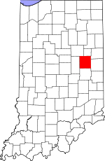
Delaware County, Indiana Basics:


Delaware County Indiana - Government Site

Population: 117,423
Area: 392 square miles
County seat: Muncie
Area code(s) in use: 765
Time zone: EST
High school graduate or higher: 86.0%
Bachelor's degree or higher: 22.2%
Median household income: $38,215
Persons in poverty: 21.0%
Home ownership rate: 64.8%
Mean travel time to work: 20.0 minutes


Adjacent counties:
Blackford  Grant  Henry  Jay  Madison  Randolph  

Find in Indiana

Map of the Delaware County area


Our detail map of Delaware County shows the Delaware County, Indiana boundary lines and other interesting items.

Places in Delaware County, Indiana

  Airports     show all on map

Belknap-Icarus Acres Airport, Carroll's Airpark, Chuck's Airport, Delaware County Regional Airport, Diamond P. Field Airport, Finney's Airpark, Horizon Field Airport, Reese Airport, Selma Airport

  Buildings     show all on map

Albany - Delaware Township Volunteer Fire Department, Albany Emergency Medical Services, Albany Fire Department, Center Township Emergency Services Station 12, Center Township Emergency Services Station 13, Delaware County Airport Authority Fire Department, Delaware County Emergency Medical Services, Eaton Emergency Medical Services, Gaston Volunteer Fire Department, Hamilton Township Fire Department, Liberty Township Volunteer Fire Department, Meridian Services, Monroe Township Cowan Volunteer Fire Department, Mount Pleasant - Yorktown Fire Department, Muncie Fire Department, Renaissance Specialty Hospital of Central Indiana, Salem Township Fire Department

  Canals     show all on map

Bosman Ditch, Branson Ditch, Carmichael Ditch, Collins Ditch, Conningham Ditch, Cunningham Ditch, Gibson Ditch, Hayden Ditch, Heath Ditch, Hedgeland Ditch, Holdren Ditch, Holt Ditch, Johns Ditch, Love Ditch, Rees Ditch, Riggins Ditch, Shoemaker Ditch, Steel Ditch, Stewart Ditch, Stoch Ditch, Studebaker Ditch, Swearengen Ditch, Thurston Ditch, Van Devender Ditch, Yeager Finley Manard Ditch

  Cemeteries     show all on map

Beech Grove Cemetery, Black Cemetery, Bortsfield Cemetery, Buckles Cemetery, Cullen Cemetery, Elizabethtown Cemetery, Elm Ridge Memorial Park, Fairview Cemetery, Felton Cemetery, Freidline Cemetery, Gardens of Memory Cemetery, Godlove Cemetery, Graham Cemetery, Granville Cemetery, Hawk Cemetery, Jones Cemetery, Leaird Cemetery, Macedonia Cemetery, McKinley Cemetery, Memorial Park, Mount Pleasant Cemetery, Mount Tabor Cemetery, Mount Zion Church Cemetery, Nottingham Cemetery, Olive Branch Cemetery, Orr Cemetery, Saunders Cemetery, Sharp Cemetery, Sparr Cemetery, Strong Cemetery, Sunderland Cemetery, Thompson Cemetery, Tomlinson Cemetery, Truitt Cemetery, Union Cemetery, Union Cemetery, Wheeling Cemetery, White Cemetery

  Churches     show all on map

Antioch Church, Beech Grove Church, Bethel Church, Burlington Church, Center Chapel, Corinth Church, Corinth Church, Delaware Chapel, Eden Church, Harris Chapel, Hofherr Chapel, Kings Chapel, Memorial Church, Mount Olive Church, Mount Pleasant Church, Mount Pleasant Church, Mount Zion Church, Olive Chapel, Philadelphia Church, Pikes Peak Church, Pleasant Grove Church, Pleasant Run Church, Prairie Grove Church, Saint Andrews Church, Saint Pauls Church, Shady Grove Church, Southside Church, Tabor Church, Temple Church, Union Church, Union Grove Church, Westside Church, White Church, Zion Church

  Dams     show all on map

Prairie Creek Reservoir Dam

  Hospitals     show all on map

Ball Memorial Hospital

  Lakes     show all on map

Burlington Lake, Emerald Lake, Jackson Lake, Phillips Lake

  Locales     show all on map

Delaware Country Club, Green Hills Country Club, John B And June M Scheumann Stadium, Northwest Plaza Shopping Center

  Mines     show all on map

Irving Brothers Stone and Gravel Pit

  Parks     show all on map

Bradford Park, Camp Munsee, Camp Redwing, Cowing Park, Guthrie Park, Heekin Park, McCulloch Park, McCullouch Park, Riverview Park, Rose Park, Thomas Park, Tuhey Park, Westside Park

  Populated Places     show all on map

Albany, Andersonville, Anthony, Aultshire, Bethel, Cammack, Cowan, Creston, Cross Roads, Daleville, Desoto, Drew, Eaton, Gaston, Gates Corner, Granville, Hyde Park, Irvington, Janney, Liberty Corners, Mayfield, Medford, Middletown Park, Morningside, Mount Pleasant, Muncie, New Burlington, Oakville, Progress, Reed Station, Royerton, Selma, Shideler, Smithfield, Stockport, West Muncie, Wheeling, Woodland Park, Yorktown

  Reservoirs     show all on map

Jim Lake, Prairie Creek Reservoir

  Schools     show all on map

Albany Elementary School, Anthony Elementary School, Ball State University, Benjamin Franklin Middle School, Bethel Home Place for Boys, Blaine School, Burris School, Center School, Central High School, Claypool Elementary School, Daleville Elementary School, Daleville High School, Eaton Elementary School, Emerson School, Field School, Forest Park Elementary School, Garfield Elementary School, Gaston Elementary School, Harrison Elementary School, Harrison School, Jefferson School, Kuhner Junior High School, Lincoln School, Longfellow Elementary School, McKinley High School, McKinley Middle School, Mitchell Elementary School, Morrison Mock Elementary School, North View Elementary School, Northside High School, Perry Elementary School, Pleasant View Elementary School, Riley Elementary School, Roosevelt School, Saint Mary School, Selma Elementary School, Selma Middle School, Southside Senior High School, Stevenson School, Storer Middle School, Sutton Elementary School, Wapahani High School, Washington-Carver Community Elementary School, Wes-Del Middle School, Wes-Del Senior High School, West Longfellow School, West View Elementary School, Wilson Middle School, Yorktown High School, Yorktown Middle School

  Streams     show all on map

Austin Run, Bethel Run, Boot Run, Buckles Run, Burlington Run, Champion Run, Corinth Run, Del Creek, Dodge Creek, Dry Branch, Eagle Branch, Easy Run, Felton Creek, Flat Run, Ford Run, Hamilton Ditch, Huffman Creek, Jakes Creek, Janney Run, Jay Branch, Jones Run, Kill Creek, Little No Name Creek, Macedonia Creek, Medford Drain, Mount Pleasant Branch, Mud Creek, Mud Creek, Muncie Creek, No Name Creek, Packard Run, Path Run, Pike Creek, Pleasant Run Creek, Prairie Creek, Rail Branch, Reed Branch, Reed Run, Rim Run, Short Run, Short Run, Small Branch, Spoke Run, Town Run, Trail Run, Truitt Ditch, Water Run, Welsh Creek, York Prairie Creek

  Swamps     show all on map

Old Prairie Swamp

  Towers     show all on map

WBST-FM (Muncie), WBST-FM (Muncie), WERK-AM (Muncie), WLBC-AM (Muncie), WLBC-FM (Muncie), WWHI-FM (Muncie),

Delaware County, Indiana Population By Race (2012 estimate)

RacePopulation
WhiteDelaware County White population 105,094105,093  
BlackDelaware County Black population 8,3378,337
MixedDelaware County Mixed population 2,3482,348
AsianDelaware County Asian population 1,2921,291
American IndianDelaware County American Indian population 352352
Hawaiian & Pacific IslanderDelaware County Hawaiian & Pacific Islander population 117117

Additional population tables :
State population table
Indiana population by county