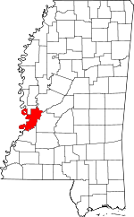
Warren County, Mississippi Basics:


Warren County Mississippi - Government Site

Population: 48,108
Area: 589 square miles
County seat: Vicksburg
Area code(s) in use: 601
Time zone: CST
High school graduate or higher: 82.2%
Bachelor's degree or higher: 24.0%
Median household income: $40,876
Persons in poverty: 23.0%
Home ownership rate: 65.7%
Mean travel time to work: 18.7 minutes


Adjacent counties:
Claiborne  East Carroll (LA)  Hinds  Issaquena  Madison (LA)  Tensas (LA)  Yazoo  
Find in Mississippi

Map of the Warren County area


Our detail map of Warren County shows the Warren County, Mississippi boundary lines and other interesting items.

Places in Warren County, Mississippi

  Airports     show all on map

Dale Landing Strip Airport, Diamond Point Landing Strip, Hammett Helipad, Magnolia Airport, Parker Landing Strip, Vicksburg Municipal Airport, Whitaker Airport

  Areas     show all on map

Davis Island, Diamond Island, Diamond Island Towhead, Forest Home Towhead, Hurricane Island, Island Number One Hundred Two, Middle Palmyra Island, Palmyra Island Number One Hundred Six, Racetrack Towhead

  Bars     show all on map

Nebraska Bar, Newton Bend Bar, Oak Bend Upper Bar, Racetrack Bar, Ursino Bar

  Bends     show all on map

Bedford Bend, Davis Island Bend, Millikens Bend, Newtown Bend, Oak Bend, Palmyra Bend, Tuscumbia Bend

  Bridges     show all on map

Fishers Bridge, Two Mile Bridge (historical)

  Buildings     show all on map

Bovina Volunteer Fire Department, Culkin Volunteer Fire Department, Eagle Lake Volunteer Fire Department, Eagle Lake Volunteer Fire Department Substation, Fisher Ferry Volunteer Fire Department, Fisher Ferry Volunteer Fire Department Substation, Letourneau Volunteer Fire Department Station 1, Letourneau Volunteer Fire Department Station 2, Marian Hill Chemical Dependency Center, Northeast Warren County Volunteer Fire Department, Northeast Warren County Volunteer Fire Department Station 2, Promise Hospital of Vicksburg, USS Cairo Museum, Vicksburg City Hall, Vicksburg City Library, Vicksburg Fire Department Central Station, Vicksburg Fire Department Station 2, Vicksburg Fire Department Station 5, Vicksburg Fire Department Station 6, Vicksburg Fire Department Station 7, Vicksburg Fire Department Station 8, Vicksburg Fire Department Station 9, Vicksburg Municipal Auditorium, Warren County Courthouse

  Canals     show all on map

Yazoo River Diversion Canal

  Capes     show all on map

Browns Point, Diamond Point, Kings Point

  Cemeteries     show all on map

Allen Cemetery, Anshe Chesed Cemetery, Beard Cemetery, Beulah Cemetery, Brickhouse Cemetery, Brierfield Cemetery, Brunswick Cemetery, Cedars Cemetery, Crocket Cemetery, Flower Hill Cemetery, Flowers Cemetery, Glass Cemetery, Hackler Cemetery, Harris Cemetery, Henry-Grant Cemetery, Kiger Cemetery, Lewis Cemetery, Marley Cemetery, Mount Albin Cemetery, Mount Giving Cemetery, Neely Cemetery, Oakland Cemetery, Old Savoy Cemetery, Parker Cemetery, Sadler Cemetery, Tates Cemetery, Taylor Cemetery, Vicksburg National Cemetery, Wright Cemetery

  Census     show all on map

Beechwood Census Designated Place

  Channels     show all on map

Diamond Island Cutoff

  Churches     show all on map

Antioch Church, Asberry Church (historical), Beach Grove Church, Bethlehem Church, Bethlehem Church (historical), Bovina Baptist Church, Bovina Methodist Church, Bowmar Avenue Baptist Church, Bradley Chapel, Brookhaven Church, Bunton Temple Christian Methodist Episcopal Church, Burnstand Church, Calvary Church, China Grove Church, China Grove Church, Christian Home Church, Christian Home Church, Church of Christ, Clover Valley Church, Cool Spring Church, Crawford Street United Methodist Church, Eagle Lake Church, Episcopal Church of the Holy Trinity, Evergreen Church, First Baptist Church, First Christian Church, First Presbyterian Church, Flower Hill Church (historical), Goodrum Church, Grace Church, Holly Grove Missionary Baptist Church, Holy Hill Church, Hopewell Church, Immanuel Church, Jackson Street Baptist Church, Jones Chapel, King Davis Church, King Solomon Baptist Church, King Solomon Church, Kingdom Hall Church, Locust Grove Church, Lynch Chapel, Mercy Seat Church, Morning Star Church, Morning Star Church, Morning Star Church, Mount Albin Church, Mount Ararat Church, Mount Arrat Church, Mount Carmel Missionary Baptist Church, Mount Hebron Church, Mount Olive Church, Mount Olive Church, Mount Pilgrim Church, Mount Pilgrim Church, Mount Pisgah Church, Mount Zion Church, Mount Zion Church, Mount Zion Church, Mount Zion Number 1 Baptist Church, New Hope Church, New Zion Church, Oakland Chapel, Oakland Church, Parkview Church, Pilgrims Rest Church, Pleasant Hill Church, Pleasant Valley Church, Pleasant Valley Church, Porters Chapel, Porters Chapel, Providence Church, Redbone Church, Redwood Methodist Church, Ridgeway Church, Rose Hill Church, Saint Albans Church, Saint James Church, Saint John Church, Saint Marks Church, Saint Marys Catholic Church, Saint Marys Episcopal Church, Saint Paul Church, Saint Pauls Church, Shady Grove Church, Shiloh Primitive Baptist Church, Travis Chapel, Trinity Church, Vicksburg Church of God in Christ, Wayside Church, West Harper Church, White Stone Church, Woodlawn Baptist Church

  Cliffs     show all on map

Snyders Bluff

  Crossings     show all on map

Baldwins Ferry (historical), Birdsong Ferry (historical), Bushs Ferry (historical), Eagle Lake Ferry, Halls Ferry (historical), Horners Ferry (historical), Interchange 11, Interchange 15, Interchange 1A, Interchange 1B, Interchange 1C, Interchange 3, Interchange 4, Interchange 5, Jones Ford, Kings Ferry, Q and C Ferry (historical), Redwood Ferry (historical), Smiths Ferry (historical), Sweets Ferry (historical), Thompsons Ferry (historical)

  Dams     show all on map

Brabston Lake Dam, Brown Lake Dam, Chickasaw Bayou Dam, Choctaw Lake Dam, Culp Lake Dam, Dornbusch Lake Dam, E E Wallis Pond Dam, Evan S Recreation Pond Dam, Evans Lake Dam, Farm Land Company Lake Dam, Farm Land Company Lake Dam, Farm Land Company Lake Dam, Hall Lake Dam, International Paper Company Lake Dam, Kellogg Lake Dam, Lake Forest Dam, Lake Henry Dam, Lake Park Dam, Latham Lake Dam, Leroy George Lake Dam, Leroy George Lake Dam, Letourneau Lake Dam, New Lake Park Dam, Old Lake Park Dam, Openwood Plantation Lake Dam, Openwood Plantation Lake Dam, Oren Bailess Lake Dam, Purks Lake Dam, R O Duncan Lake Dam, Scott Lake Dam, Southall Lake Dam, Southall Lake Dam, Southall Lake Dam, Southall Lake Dam, Southall Lake Dam, Strong Lake Dam, Thompson Lake Dam, W R Farris Lake Dam, W R Farris Lake Dam, W R Farris Pond Dam, Warrenton Heights Recreation Lake Dam, Warrenton Heights Recreation Lake Dam, Waterways Experiment Station Dam

  Guts     show all on map

Ben Slough, Boat Slough, Eagle Lake Pass, Forest Home Chute, Paw Paw Chute, Willow Bayou

  Hospitals     show all on map

Kuhn Hospital, Marine Hospital (historical), Mercy Hospital (historical), River Region Medical Center, River Region Medical Center West

  Lakes     show all on map

Alligator Lake, Beaver Pond, Blue Lake, Brecount Lake, Brushy Lake, Brushy Lake, Cameron Lake, Centennial Lake, Centennial Lake, Congo Lake, Cook Lake, Cooks Lake, Cypress Lake, Cypress Lake, Duck Lake, Goose Lake, Goose Lake, Grassy Lake, Halpino Lake, Hodges Lake, Horseshoe Lake, Horseshoe Lake, Horseshoe Lake, Horseshoe Lake, Horseshoe Lake, Indian Camp Lake, John Thomas Lake, July Lake, Little Flat Lake, Little Horseshoe Lake, Little Lake, Long Lake, Long Lake, McNutt Lake, Miller Lake, Old Chute, Paine Lake, Palmyra Lake, Panther Lake, Pervis Lake, Scotts Lake, Simmons Lake, Taylor Lake, Tent Lake, Thompson Lake, Tucker Lake, Twin Lake, West Carter Lake, Youngs Lake

  Levees     show all on map

Brunswick Circle Levee

  Locales     show all on map

Adams Landing (historical), Ball Ground Creek Landing (historical), Barnes Bayou Landing (historical), Beasleys Landing (historical), Boats Slough Landing (historical), Brierfield (historical), Browns Point Landing, Brunswick Landing (historical), Buena Vista Plantation (historical), Cannon Point Landing, Cardiff Landing (historical), Ceres Plantation, Chickasaw Bayou Landing (historical), Collins Bayou Landing (historical), Crooks Point Landing (historical), Forest Home Landing (historical), Forest Home Plantation (historical), Foxs Landing (historical), Gaskins Landing (historical), Great Redoubt (historical), Halpino Landing (historical), Haynes Bluff Landing (historical), James Plantation (historical), Killikrankia Plantation (historical), Kings Landing (historical), Lakes Landing (historical), Landing Number Eightyfive (historical), Little Cuba Landing, Little Deer Creek Landing (historical), Locust Grove Landing (historical), Magnolia (historical), McCarthys Landing (historical), Meredith Plantation (historical), Mount Alban Station (historical), Oak Bend Landing (historical), Old Landing (historical), Old Marley Landing, Openwood Country Club, Palmyra (historical), Paw Paw Landing, Paxtons Landing (historical), Peeler Landing, Purvis Landing (historical), Railroad Redoubt (historical), Redwood Landing (historical), Ross Landing (historical), Second Texas Lunette (historical), Skillakalla Bayou Landing (historical), Smedes Plantation (historical), Snyders Bluff Landing (historical), South Fort (historical), Stockade Redan (historical), Taylor Plantation, Taylors Landing (historical), Third Louisiana Redan (historical), Thompson Landing (historical), United States Waterways Experiment Station, Ursino (historical), Ursino Landing (historical), Vicksburg Country Club, Vicksburg Harbor Project, Vicksburg Water Pollution Control Center, Warren County Farm (historical), White House Landing (historical), Williams Plantation, Youngs Point Landing

  Military     show all on map

Battery De Golyer (historical), Battery Selfridge (historical), Fort Garrott (historical)

  Parks     show all on map

Bluff Experimental Forest, Vicksburg City Park, Vicksburg Memorial Stadium, Vicksburg National Military Park, Warren County Recreational Complex

  Populated Places     show all on map

Allen, Antioch, Ballground, Beechwood, Bellemeade, Bellevule, Bernard Acres, Big Black, Blakely, Bovina, Bradley Chapel, Brunswick, Cedars, Culkin, Eagle Bend, Eldorado, Floweree, Flowers, Great Lake Estates, Greenbriar, Haynes Bluff, Hurricane, Jeff Davis, Jetts, Jonestown, Katzenmeyer, Kimberly, Kings, Lake Forest, Lake Park, Lakewood, Le Tourneau, Long Lake, Newmans, Newmans Grove, Oak Ridge, Openwood Plantation, Peelers, Porters Chapel, Rawhide, Redbone, Redwood, Rose Hill, Russellville, Sherwood Forest, Signal, Simrall, Southall, Southhaven, Speeds Addition, Stout, Timberlane, Twin Lake, Valley Mills, Vicksburg, Villanova, Walsh, Waltersville, Warrenton, Warrenton Heights, Woodlawn, Yokena, Youngton

  Post Offices     show all on map

Ballground Post Office (historical), Eldorado Post Office (historical), Floweree Post Office (historical), Mount Vernon Post Office (historical), Nanachehaw Post Office (historical), Newbell Post Office (historical), Youngton Post Office (historical)

  Ranges     show all on map

Walnut Hills

  Reservoirs     show all on map

Brown Lake, Jones Lake, Lake Henry, Rings Lake, Scott Lake, Southall Lake, Swett Lake

  Schools     show all on map

All Saints College (historical), All Saints Episcopal School, Bear Creek School (historical), Bedford School (historical), Bethlehem School (historical), Bethlehem School (historical), Bovina Elementary School, Bowman School, Bowmar Avenue Elementary School, Brickhouse School (historical), Brookhaven School (historical), Carr Junior High School, Cedars School (historical), Clear Creek School (historical), Cole School (historical), Cooper High School, Cooper School (historical), Countrymen School (historical), Culkin Academy, Fernwood School (historical), Grove Street Elementary School, Halls Ferry Elementary School, Hickory Tree School (historical), Holy Hill School (historical), Jeff Davis School (historical), Jett School, Kings School, Kings School, Marley School (historical), McIntrye School, Oak Ridge School (historical), Redwood Elementary School, Rosa Temple School, Saint Aloysius High School, Saint Francis School, Warren Central School, Warrenton Elementary School

  Springs     show all on map

Cowans Spring

  Streams     show all on map

Adams Bayou, Ballground Creek, Bear Creek, Big Bogue Desha, Blackman Bayou, Bliss Creek, Buck Creek, Butts Creek, Chickasaw Bayou, Clear Creek, Collins Creek, Cooks Bayou, Corn House Creek, Cornhouse Creek, Cowan Creek, Crouches Creek, Deer Creek, Durden Creek, False River (historical), Fox Creek, Glass Bayou, Hamer Bayou, Hatcher Bayou, Hennesseys Bayou, Jim Bayou, Little Bear Creek, Little Bogue Desha, Markham Creek, Mill Creek, Mint Spring Branch, Muddy Creek, Paces Bayou, Palmyra Chute, Price Creek, Redbone Creek, Rocky Creek, Shiloh Creek, Silver Creek, Skillikalia Bayou, Stouts Bayou, Summer Seat Creek, Willow Bayou, Wren Bayou, Wrights Creek, Yazoo River

  Summits     show all on map

Fort Hill

  Swamps     show all on map

Campbell Swamp, Fish Lake, Whteman Lake, Willow Bayou, Wilton Bayou

  Towers     show all on map

Jeff Davis Lookout Tower, Oak Ridge Lookout Tower, WJFL-AM (Vicksburg), WJFL-AM (Vicksburg), WKYV-FM (Vicksburg), WQBC-AM (Vicksburg), WQMV-FM (Vicksburg),

Warren County, Mississippi Population By Race (2012 estimate)

RacePopulation
WhiteWarren County White population 24,24624,246  
BlackWarren County Black population 22,89922,899
AsianWarren County Asian population 433432
MixedWarren County Mixed population 385384
American IndianWarren County American Indian population 144144
Hawaiian & Pacific IslanderWarren County Hawaiian & Pacific Islander population 00

Additional population tables :
State population table
Mississippi population by county