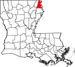
East Carroll Parish, Louisiana Basics:
East Carroll Parish Louisiana - Government Site
Population: 7,572
Area: 421 square miles
Parish seat: Lake Providence
Area code(s) in use: 318
Time zone: CST
High school graduate or higher: 65.6%
Bachelor's degree or higher: 10.7%
Median household income: $25,413
Persons in poverty: 44.9%
Home ownership rate: 58.0%
Mean travel time to work: 17.9 minutes
Adjacent counties:
Chicot (AR) Issaquena (MS) Madison Richland Warren (MS) West Carroll
Places in East Carroll Parish, Louisiana
Batton Airstrip,
Byerley Airport,
Cottonwood Airport,
Wilson Landing Field Atherton Towhead,
Cottonwood Bar Hagerman Break,
Hollybrook Crevasse,
Salem Crevasse,
Tensas Basin The Chute Albemarle Band,
Alsatia-Salem Bend,
Bunchs Bend,
Fitler Bend,
Louisina Bend,
Willow Cut Off Ashton Bridge,
Lanes Ferry Bridge Goodrich Post Light,
Lake Providence Fire Department Ditch Number Eight,
Ditch Number Four,
Ditch Number Nine,
Ditch Number One,
Ditch Number Two,
Jack Falls Canal,
Tensas Ditch,
Tensas Ditch,
Valentine Ditch Opossum Point,
Point Lookout,
Willow Point,
Wilson Point Benjamin Cemetery,
Cold Tar Cemetery,
Gailliard Cemetery,
Heavenly Rest Memorial Park,
Jerusalem Cemetery,
King Solomon Cemetery,
Lone Star Cemetery,
Old Saint Paul Cemetery,
Old Sweet Canaan Cemetery,
Panola Cemetery,
Providence Memorial Park,
Tyrone Cemetery,
Way Way Cemetery Newman Cutoff,
Opossum Chute Assembly of God Church,
Cane Ridge Church Number 1,
Cane Ridge Church Number 2,
China Grove Church,
Church of Christ,
Church of Christ (historical),
Corbin Ferry Church,
Elmwood Church,
Evening Star Church,
Evening Star Number 2 Church,
Evergreen Church,
First Pentecostal Church,
Friendship Church,
Herringville Church,
Jerusalem Church,
Joyce Chapel (historical),
King Solomon Church,
Lanes Ferry Church,
Little King Solomon Church (historical),
Melbourne Church,
Morning Star Church (historical),
Morningstar Church,
Mound Chapel,
Mount Lebanon Church (historical),
Mount Olive Church (historical),
Mount Pleasant Church,
Mount Wade Church,
Mount Zion Church,
New Bethlehem Church,
New Hope Church,
New Hope Church,
New Light Church,
New Morning Star Island Church,
New Zion Church,
Oakland Ridge Church,
Olivedell Church,
Pilgrim Rest Church,
Pleasant Green Church,
Rose Hill Church,
Saint Mary Church,
Saint Paul Church,
Seventh Star Church,
Sweet Canaan Church Corbins Ferry (historical),
Epps Ferry (historical),
Montgomery Ferry (historical) Bayou Providence,
Black Bayou,
Bull Bayou,
Caney Bayou,
Cypress Bayou,
Duckpond Bayou,
Fishers Creek,
Jones Bayou,
Jump Log Bayou,
Mud Slough,
Otter Bayou,
Sandy Bayou,
Sassafras Bayou,
Transylvania Chute,
Wade Bayou,
Wildcat Bayou East Carroll Parish Hospital Duncansby Towhead,
Henderson Island,
Lost Island,
Newman Towhead,
Pittman Island Albemarle Lake,
Bass Lake,
Broad Lake,
Caraway Lake,
Chotard Lake,
Concord Lake,
Cottonwood Chute,
Doe Lake,
Gassoway Lake,
Grassy Lake,
Johnson Lake (historical),
Lake Providence,
Louisiana Lake,
Old River Chute,
Pumpkinseed Lake,
Round Lake,
Snag Lake,
Stump Hole,
Swan Lake,
Vinning Lake,
Willow Lake,
Wilson Point Lake (historical) Goodrich Revetment,
Hagaman Revetment,
La Bend Revetment,
Lake Providence Revetment,
Point Lookout Dikes,
Willow Cutoff Dike Belle Mead Planatation,
Bowie Plantation,
Browns Landing,
Buck Meadows Plantation,
Cottonwood Landing (historical),
Desona Plantation,
Dogtail Landing,
East Carroll Prison Farm,
Goodrich Landing,
Goodrich Plantation (historical),
Henderson Landing,
Lake Providence Port,
Langwood Landing (historical),
Longwood Plantation,
Mackey Lodge,
Mayburn Lodge,
Melbourne Plantation,
Melville Plantation (historical),
Olivedell Plantation,
Point Lookout Landing,
Tompkins Plantation,
Tyrone Plantation,
Valewood Landing,
Walkers and Fishers Sawmill (historical),
Way Way Plantation,
Wilson Point Landing (historical) Bowie Oil Field,
Ruseell Bayou Oil Field Lake Providence Historic District,
Lake Providence Residential Street Historic District Alsatia,
Arlington,
Atherton,
Benham (historical),
Bomer,
Bowie,
Brunett (historical),
Cottonwood,
Gassoway,
Greenfield,
Grimes,
Henderson (historical),
Highland,
Hollybrook,
Lake Providence,
Lebanon (historical),
Millikin,
Monticello,
Panola,
Pilcher Point,
Robertdale (historical),
Roosevelt,
Shelburn,
Sondheimer,
Stamboul (historical),
Transylvania,
Waddell,
Wilman,
Wilson Point (historical) Alsatia Post Office (historical), Ashton Post Office (historical), Atherton Post Office (historical), Benham Post Office (historical), Brunett Post Office (historical), Goodrichs Landing Post Office (historical),
Lake Providence Post Office, Millikin Post Office (historical), Panola Post Office (historical), Pilcher Point Post Office (historical), Robertdale Post Office (historical), Roosevelt Post Office (historical), Semple Post Office (historical), Shelburn Post Office (historical),
Sondheimer Post Office (historical), Stamboul Post Office (historical),
Transylvania Post Office (historical), Villa Vista Post Office (historical), Waddell Post Office (historical), Wilsons Point Post Office (historical)
Adams School,
Ashton School (historical),
Briarfield Academy School,
Henderson School,
Lake Providence Junior High School,
Lake Providence Senior High School,
Lickskillet School (historical),
Louisiana Technical College Margaret Surles Branch,
Monticello High School,
Northside Elementary School,
Southside Elementary School,
Transylvania Elementary School (historical),
Winterfield School (historical) Baxter Bayou,
Boggy Bayou,
Brushy Bayou,
Buck Bayou,
Cypress Bayou,
Cypress Bayou,
Dry Prong Bayou,
Dry Prong Bayou,
Graveyard Bayou,
Jack Falls Bayou,
Loggy Bayou,
Long Lake Bayou,
Maiden Doe Bayou,
Russell Bayou,
Three Bayou,
Wilson Bayou,
Winters Bayou Cypress Brake KLPL-AM (Lake Providence),
KLPL-FM (Lake Providence),
KLPL-FM (Lake Providence),

