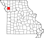
Clinton County, Missouri Basics:


Clinton County Missouri - Government Site

Population: 20,525
Area: 419 square miles
County seat: Plattsburg
Area code(s) in use: 816
Time zone: CST
High school graduate or higher: 90.6%
Bachelor's degree or higher: 17.8%
Median household income: $53,234
Persons in poverty: 9.8%
Home ownership rate: 73.6%
Mean travel time to work: 27.4 minutes


Adjacent counties:
Buchanan  Caldwell  Clay  Daviess  DeKalb  Platte  Ray  

Find in Missouri

Map of the Clinton County area


Our detail map of Clinton County shows the Clinton County, Missouri boundary lines and other interesting items.

Places in Clinton County, Missouri

  Airports     show all on map

Block Air Village Airport, Cameron Community Hospital Heliport, Cameron Memorial Airport, Clark Airport, Kimray Airport, Lathrop Family Practice Heliport, Mac's Field Airport, Northwood Airport, O'Connor Landing Strip, Plattsburg Airpark, Sellers Airport, Starr Airport

  Bridges     show all on map

Linn Branch Bridge

  Buildings     show all on map

Cameron Fire Department, Cameron Police Department, Clinton County Sheriff's Office, Edgerton - Trimble Fire Protection District, Gower Fire Protection District, Gower Police Department, Lathrop Fire and Rescue, Lathrop Police Department, Plattsburg Fire Protection District

  Cemeteries     show all on map

Antioch Cemetery, Bethel Cemetery, Calvary Cemetery, Converse Cemetery, Cook Cemetery, Crooked River Cemetery, Deer Creek Cemetery, Eberts Cemetery, Estep Cemetery, Evergreen Cemetery, Fairview Cemetery, Graceland Cemetery, Grayson Cemetery, Greenlawn Cemetery, Hanks Cemetery, Harlan Cemetery, Keller Cemetery, Lathrop Cemetery, McWilliams Cemetery, Mount Carmel Cemetery, Mount Washington Cemetery, Mount Zion Cemetery, Oakland Cemetery, Old Presbyterian Cemetery, Osborn-Evergreen Cemetery, Packard Cemetery, Reed Cemetery, Round Prairie Cemetery, Saint Munchin Cemetery, Transue Cemetery, Turney Cemetery

  Churches     show all on map

Bethany Church, Brethren Church, Deer Creek Union Church (historical), Independence Church, Lebanon Church (historical), Mount Zion Church, Pleasant Hill Church, Pleasant Valley Church (historical), Smith Fork Church, Stony Point Church, Town and Country Church

  Dams     show all on map

Burlington Reservoir Dam, Crouch Lake East Dam, Crouch Lake West Dam, Everett Quarries Lake Dam, Freeman Farm Number Three Dam, Freeman Farm Number Two Dam, Freeman Farms Dam Number One, Freemans Farm Dam Number Four, Gower Reservoir Dam, Hartell Lakes Dam, Hartell Lakes Dam, Jones Lake Section 10 Dam, Lake Arrowhead Dam, Lake Concord Dam, Lake Joseph Dam, Lathrop Lake and Forest Club Dam, McGinness Lake Dam, Morse Lake Dam, Newby Lake Dam, Plattsburg Old Reservoir Dam, Six Mile Lane Lake Dam, Skipton Lake Dam, Spring Lake Dam, Trimble Wildlife Dam, Woods Dam, Zurbuchen Lake Dam

  Hospitals     show all on map

Cameron Regional Medical Center

  Lakes     show all on map

Burlington Lake, Lake Lenore

  Locales     show all on map

Hixson Bridge (historical), Hixson Mill (historical), Hords Spur (historical), Lott School (historical), Major, Prairie Point School (historical), Tanner

  Parks     show all on map

Perkins Park, Smithville Lake State Wildlife Area, Trimble Wildlife Management Area, Wallace State Park

  Populated Places     show all on map

Bainbridge, Barnesville, Bee Hive, Braley, Cameron, Converse, Delaney, Gower, Grayson, Guyton, Haynesville, Hemple, Keystone (historical), Lathrop, Lilly, Maple Hill, Mecca, Moors, Osborn, Perrin, Plainview, Plattsburg, Scearces, Somerville, Starfield, Trimble, Turney, West Keystone, Westbridge, Wexford

  Post Offices     show all on map

Anderson Post Office, Eskin Post Office, Mount Refuge Post Office, Thrush Post Office

  Reservoirs     show all on map

Bill Woods Ranch Lake, Hartel Lakes, Hartell Lake, Hartell Lakes, Kings Lake, Lake Allaman, Lake Arrowhead, Lake McGinness, Lathrop Lake, Morse Lake, Newby Lake, Number 17 Reservoir, Plattsburg Old Reservoir, Six Mile Lane Lake, Spring Lake, Trimble Wildlife Lake, Weakley Lake

  Schools     show all on map

Ash Grove School (historical), Barnesville School (historical), Bonham School, Brooking School (historical), Cameron High School, Cameron Middle School, Campbell School (historical), Center Prairie School, Dale School (historical), Deer Creek School (historical), Duncan School, East Buchanan Elementary School, East Buchanan High School, Ellis Elementary School, Fairview School, Forest Hill School, Fountain School (historical), Grand Prairie School, Hall School, Harbor School (historical), Haynesville School, Hazel Dell School (historical), Hemple School (historical), High Prairie School, Hord School, Huffaker School, Jones School, Keystone School (historical), Lathrop Elementary School, Lathrop High School, Lathrop Middle School, Leg Church School, Lily School (historical), Log Church School, Long Branch School (historical), Lyon School (historical), Madden School, Martin School (historical), Marun School, McCullys School, Mount Carmel School, Mount Hope School (historical), Mount Zion School (historical), Oak Dale School, Oak Grove School, Oakdale School, Oakland School, Park School (historical), Parkview Elementary School, Perrin School (historical), Plainview School (historical), Platte Center School, Plattsburg High School, Plattsburg Middle School, Pleasant Grove School (historical), Pleasant Hill School (historical), Pleasant Prairie School (historical), Pleasant Ridge School, Potter School (historical), Prairie Cottage School (historical), Prairie Dell School (historical), Prairie Hill School (historical), Prairie Lawn School (historical), Rat Den School, Riggs School (historical), Round Prairie School (historical), Spring Hill School (historical), Stony Point School, Stony Point School (historical), Sunny Grove School (historical), Turning Point School, Victory School (historical), Wagul School, Walnut Grove School (historical), Whetsett School (historical), Winn School (historical)

  Streams     show all on map

Brushy Creek, Deer Creek, Funkhouser Creek, Grindstone Creek, Horse Fork, Lingenfelter Branch, Linn Branch, Little Shoal Creek, McGuire Branch, Minkler Branch, Reservoir Branch, Roberts Branch, Rock Branch, Roger Branch, Smith Fork

  Towers     show all on map

KMRN-AM (Cameron),

Clinton County, Missouri Population By Race (2012 estimate)

RacePopulation
WhiteClinton County White population 19,62219,621  
MixedClinton County Mixed population 328328
American IndianClinton County American Indian population 164164
AsianClinton County Asian population 8282
Hawaiian & Pacific IslanderClinton County Hawaiian & Pacific Islander population 00

Additional population tables :
State population table
Missouri population by county