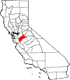
Stanislaus County, California Basics:


Stanislaus County California - Government Site

Population: 521,450
Area: 1495 square miles
County seat: Modesto
Area code(s) in use: 209
Time zone: PST
High school graduate or higher: 76.0%
Bachelor's degree or higher: 16.3%
Median household income: $49,866
Persons in poverty: 19.2%
Home ownership rate: 59.1%
Mean travel time to work: 26.5 minutes


Adjacent counties:
Alameda  Calaveras  Mariposa  Merced  San Joaquin  Santa Clara  Tuolumne  

Find in California

Map of the Stanislaus County area


Our detail map of Stanislaus County shows the Stanislaus County, California boundary lines and other interesting items.

Places in Stanislaus County, California

  Airports     show all on map

Emanuel Medical Center Heliport, Flying Bull Airport, Mapes Ranch Airport, Modesto City-County Airport-Harry Sham Field, Oakdale Airport, Patterson Airport, Peterson Airport, Turlock Airpark, Westley Airport, Yandell Ranch Airport

  Areas     show all on map

Grider Island

  Basins     show all on map

French Pit

  Bays     show all on map

Duck Cove, Erickson Slough

  Beaches     show all on map

Cocklebur Beach

  Bridges     show all on map

Basso Bridge, Crows Landing Bridge, Oakdale Bridge, Orange Blossom Bridge, Shiloh Bridge

  Buildings     show all on map

American Medical Response, Bethany Home for the Aged, Burbank Paradise Clubhouse, Burbank Paradise Fire Protection District, Carnegie Center for the Arts, Ceres Branch Stanislaus County Free Library, Ceres City Hall, Ceres Emergency Services Station 1, Ceres Emergency Services Station 2, Ceres Emergency Services Station 3, Ceres Emergency Services Station 4, Columbia Center, County Center Number Three, Denair Branch Stanislaus County Free Library, Denair Fire Protection District, Department of Forestry and Fire Protection Station 15 Del Puerto, Emanuel Medical Center Library, Empire Branch Stanislaus County Free Library, Fire Station Number 4, Hughson Branch Stanislaus County Free Library, Hughson City Hall, Hughson Fire Protection District, Hughson Paramedic Ambulance Company, Keyes Branch Stanislaus County Free Library, Keyes Fire Protection District, King-Kennedy Center, Maddux Youth Center, McClure Historical Country House, McHenry Mansion, McHenry Public Library, Mediflight of Northern California, Modesto Branch Stanislaus County Free Library, Modesto City Hall, Modesto Fire Department Station 1 Headquarters, Modesto Fire Department Station 10, Modesto Fire Department Station 11, Modesto Fire Department Station 2, Modesto Fire Department Station 3, Modesto Fire Department Station 4, Modesto Fire Department Station 5, Modesto Fire Department Station 6, Modesto Fire Department Station 7, Modesto Fire Department Station 8, Modesto Fire Department Station 9, Modesto Junior College Library, Mountain View Fire Protection District, Mountain View Fire Protection District Station 2, Newman Branch Stanislaus County Free Library, Newman Memorial Center, Newman Youth Center, Nirvana Drug and Alcohol Treatment, North Hall, Oak Valley Care Center, Oakdale Branch Stanislaus County Free Library, Oakdale City Fire Department Station 1, Oakdale City Fire Department Station 2, Oakdale City Hall, Oakdale Rural Fire Protection District Station 1, Oakdale Rural Fire Protection District Station 2, Oakdale Rural Fire Protection District Station 3, Orestimba Nursery, Patterson Branch Stanislaus County Free Library, Patterson City Hall, Patterson District Ambulance, Patterson Fire Department Station 1, Petroleum Helicopters Air Medical Team Modesto, Riverbank City Hall, Salida Branch Stanislaus County Free Library, Salida Fire Protection District Station 1, Salida Fire Protection District Station 2, Salida Fire Protection District Station 3, South Hall, Stanislaus Consolidated Fire Protection District Station 31, Stanislaus Consolidated Fire Protection District Station 32, Stanislaus Consolidated Fire Protection District Station 33, Stanislaus Consolidated Fire Protection District Station 34, Stanislaus Consolidated Fire Protection District Station 35, Stanislaus Consolidated Fire Protection District Station 36, Stanislaus County Courthouse, Stanislaus County Juvenile Center, Stanislaus County Law Library, Stanislaus Library, The Center Building, The Living Center Alcohol and Drug Addiction, Turlock Branch Stanislaus County Free Library, Turlock City Fire and Emergency Services Station 1, Turlock City Fire and Emergency Services Station 2, Turlock City Fire and Emergency Services Station 3, Turlock City Fire and Emergency Services Station 4, Turlock City Hall, Turlock Rural Fire Protection District, Turlock Youth Center, Valley Museum, War Memorial Auditorium, Waterford Branch Stanislaus County Free Library, West Stanislaus County Fire Protection District - City of Newman Fire Department, West Stanislaus County Fire Protection District - Patterson Fire Department Station 2, West Stanislaus County Fire Protection District Crows Landing Station, West Stanislaus County Fire Protection District Diablo Grande Station, West Stanislaus County Fire Protection District El Solyo Station, West Stanislaus County Fire Protection District Headquarters, West Stanislaus County Fire Protection District Westley Station, Westport Fire Protection District, Woodland Avenue Fire Protection District

  Canals     show all on map

Ables Drain, Adams Lateral, Albers Lateral, Birnbaum Lateral, Brichetto Lateral, Burnett Lateral, Cape Horn Lateral, Cavill Drain, Ceres Main Canal, Claribel Lateral, Clavey Lateral, Clavey Siphon, Cleveland Drain, Collins Lateral, Cometa Lateral, Crane Drain, Crane Lateral, Cross Ditch Number One, Crouch Lateral, Dixon Lateral, Dorsey Lateral, Dry Creek Lateral, East Clavey Lateral, East Pump Lateral, East Thalheim Lateral, Eaton Lateral, Fairbanks Lateral, First Lift, Gray Lateral, Hatch Drain, Hi Line Lateral, High Line Canal, Hinds Lateral, Horse Drain, Howard Lateral, Kearney Lateral, Kuhn Drain, Lambuth Lateral, Langworth Lateral, Lateral A, Lateral A, Lateral B, Lateral F, Lateral Five North, Lateral Five South, Lateral Four North, Lateral Four North, Lateral Four South, Lateral G, Lateral H, Lateral J, Lateral K, Lateral M, Lateral Number Eight, Lateral Number Eleven, Lateral Number Five, Lateral Number Five 1/2, Lateral Number Four, Lateral Number Four 1/2, Lateral Number Nine, Lateral Number One, Lateral Number Seven, Lateral Number Six, Lateral Number Three, Lateral Number Three, Lateral Number Three-B, Lateral Number Twelve, Lateral Number Two, Lateral Number Two, Lateral Six North, Lateral Six South, Lateral Three North, Lateral Three South, Lateral Two South, Leitch Lateral, Lesnini Lateral, Lower Lateral Number Four, Lower Lateral Number Three, Lower Lateral Number Two, Lower Lateral Number Two and One Half, Main Canal, Merriam Drain, Modesto Lateral Number One, Modesto Main Canal, Mootz Drain, Mootz Lateral, Morrison Siphon Lateral, Moulton Lateral, North San Joaquin Main Canal, Oakdale Lateral, Oakdale North Main Canal, Oakdale South Main Canal, Palmer Lateral, Paulsell Extension, Paulsell Lateral, Peart Lateral, Prairie Flower Drain, Reed Lateral, Rice Drain, River Road Lateral, Riverbank Lateral, Rock Creek Ditch, Rodden Lateral, Root Lateral, San Joaquin Main Canal, Schuller Lateral, Second Lift, Snedigar Lateral, South Lateral, South San Joaquin Main Canal, Southwest Lateral, Stevenot Lateral, Stowell Lateral, Thalheim Lateral, Thompson Lateral, Towne East Lateral, Townhill Lateral, Tulloch Lateral, Turlock Main Canal, Union Lateral, Upper Lateral Number Four, Upper Lateral Number Three, Upper Lateral Number Two, Upper Lateral Number Two and One Half, Upper Main Canal, Waterford Lower Main Canal, West Pump Lateral, West Stanislaus Main Canal, Westley Wasteway, Westport Drain, Wills Lateral, Wyatt Lateral, Young Lateral

  Capes     show all on map

Biscuit Point, The Narrows

  Cemeteries     show all on map

Citizens Cemetery, Del Puerto and Saint Marys Cemetery, Denair Cemetery, Grayson Cemetery, Lakewood Memorial Park, Langworth Cemetery, Roberts Ferry Cemetery, Saint Joseph Cemetery, Saint Stanislaus Cemetery, San Joachim Cemetery, Turlock Memorial Park, Woodcolony Cemetery

  Census     show all on map

Airport Census Designated Place, Bret Harte Census Designated Place, Bystrom Census Designated Place, Cowan Census Designated Place, Crows Landing Census Designated Place, Del Rio Census Designated Place, Denair Census Designated Place, Diablo Grande Census Designated Place, East Oakdale Census Designated Place, Empire Census Designated Place, Grayson Census Designated Place, Hickman Census Designated Place, Keyes Census Designated Place, Monterey Park Tract Census Designated Place, Parklawn Census Designated Place, Riverdale Park Census Designated Place, Rouse Census Designated Place, Salida Census Designated Place, Shackelford Census Designated Place, Valley Home Census Designated Place, West Modesto Census Designated Place, Westley Census Designated Place

  Channels     show all on map

Finnegan Cut

  Churches     show all on map

Assyrian Evangelical Church, Berkeley Avenue Baptist Church, Bethel Bible Church, Bethel Pentecostal Church, Bethel Temple Church, Broadway Baptist Church, Calvary Baptist Church, Church of Christ, Church of Christ, Church of Christ, Church of Christ, Church of the Four Square Gospel, Church of the Nazarene, Clinton African Methodist Episcopal Zion Church, Eastside Church of Christ, Evangelical Covenant Church, Evangelical Free Church, Faith Temple, Federated Methodist-Presbyterian Church, First Assembly of God Church, First Baptist Church, First Baptist Church, First Baptist Church, First Baptist Church, First Christian Church, First Christian Church of Turlock, First Church of Christ Scientist, First Church of Christ Scientist, First Church of Christ Scientist, First Church of God, First Church of God, First Church of the Brethren, First Church of the Nazarene, First Methodist Church, First Methodist Episcopal Church (historical), First Presbyterian Church, First Presbyterian Church, First Southern Baptist Church of Turlock, First United Methodist Church of Turlock, First United Presbyterian Church, Free Methodist Church, Free Methodist Church, Free Methodist Church, Full Gospel Tabernacle, Good Shepherd Lutheran Church, Iglesia del Pacto Evangelico de Turlock, Kingdom Hall of Jehovahs Witnesses, Livingway Tabernacle, Nazareth Lutheran Church, North Side Assembly of God Church, Our Saviours Lutheran Church, Pentecostal Church, Pentecostal Church of God, Pentecostal Church of God, Pentecostal Gospel Defenders Church (historical), Pentecostal Pathfinders Church, Portuguese Assembly of God Church, Reorganized Church of Jesus Christ of Latter Day Saints, Sacred Heart Catholic Church, Sacred Heart Roman Catholic Church, Saint Francis Episcopal Church, Saint Johns Assyrian United Presbyterian Church, Saint Johns Chapel of the Valley, Saint Louis Catholic Church, Saint Lukes Lutheran Church, Saint Marys Roman Catholic Church, Saint Matthias Episcopal Church, Saint Paul Missionary Baptist Church, Saint Pauls Episcopal Church, Saint Stanislaus Convent, Saint Stanislaus Roman Catholic Church, Saint Thaddeus Holy Apostolic Church of the East Assyrians, Saint Thomas Assyrian-Chaldean Catholic Church, Seventh Day Adventist Church, Seventh Day Adventist Church, Seventh Day Adventist Church, Truth for Today Church, Turlock Covenant Church, Westport Church (historical), Word of Life Church

  Cliffs     show all on map

Lovers Leap

  Crossings     show all on map

Burneyville Ferry (historical)

  Dams     show all on map

Cashman Dam, Dawson Lake 68-004 Dam, La Grange Dam, Littlejohns Dam, Modesto Reservoir 59-000 Dam, Orvis 560 Dam, Orvis Dam, Rodden Lake 62-003 Dam, Turlock Lake 68-003 Dam, Woodward 66 Dam

  Falls     show all on map

Finnegan Falls

  Flats     show all on map

Adobe Flat, Bachelor Valley, Ballard Flat, Chicken Flat, China Cabin Flat, Jackass Flat, Mustang Flat, Paradise Flat, Poverty Flat, Three Tree Flat

  Gaps     show all on map

Days Pass, Orestimba Narrows

  Guts     show all on map

Laird Slough

  Hospitals     show all on map

County Memorial Hospital, Del Puerto Hospital, Doctors Behavioral Health Center, Doctors Medical Center, Emanuel Hospital (historical), Emanuel Medical Center, Kindred Hospital Modesto, Modesto State Hospital, Modesto Veterinary Hospital, Oak Valley Hospital, River Bluff Convalescent Hospital, Scenic General Hospital, Stanislaus Surgical Hospital, Turlock Community Hospital

  Islands     show all on map

T Island, Whale Island

  Lakes     show all on map

Beltz Lake, Cardoza Lake, Floto Lake, Lower White Lake (historical), Pear Slough, Richie Slough, Upper White Lake (historical)

  Locales     show all on map

Ackerman Dairy, Alamo Dairy, Alberto Dairy, Amorim Dairy, Atkins Ranch, Beltran Farms, Bizzini Farm, Bonzi Sanitation Landfill, Briggsmore Plaza Shopping Center, Briggsmore Square Shopping Center, Bund Ranch, Caruso Shopping Center, Catfish Camp, Central Valley Plaza Shopping Center, Ceres Plaza Shopping Center, Ceres Shopping Center, Circle H Dairy Ranch, Circle M Nut Farms, City of Patterson Sewage Disposal, Clarot Farms, Coffee Plaza Shopping Center, College Shopping Center, Crossroad Shopping Center, Crow Farms, De Pauw Farms, Del Puerto Fire Control Station, Del Rio Golf and Country Club, Desimas and Bairos Dairy, Diamond S Ranch, Dotinga Dairy, Double D Dairy, Dryden Park Municipal Golf Course, Dutch Star Dairy, Edelweiss Dairy, El Katrina Dairy Farms Number 1, El Solyo Ranch, Fairgrounds Substation, Faith Home Teen Ranch, Fink Road Landfill, Fiscalini Farms, Foster Dairy Farms Number 3, Foster Dairy Farms Number 5, Foster Dairy Farms Number 6, Foster Poultry Farms, Frame Ranch, Frazier Nut Farms, Geer Road Landfill, Geer Substation, Gerber Ranch, Gill Ranch, Gleason Ranch (historical), Gregory Gardens Shopping Center, Haringa Dairy, Heritage Nut Farm, Herman Ranch, Hertle Dairy, Hidden Valley Dairy, Hoekstra Dairy, Hughson Substation, Isom Ranch, J and B Farms, Jones Ranch, Kamiska Farms, Kronkite Ranch, Lamb Farms, Lander Marketplace Shopping Center, Lawley Ranch, Lower Ranch, Lucas Dairy, Lumar Dairy Farms, Mapes Ranch, Marshalls Plaza Shopping Center, McHenry Village Shopping Center, Mendes Dairy, Mervyns McHenry Mall Shopping Center, Michel Ranch, Mikes Peak Lookout, Miller Ranch, Modesto Marketplace Shopping Center, Modesto Municipal Golf Course, Modesto Promenade Shopping Center, Montpelier Substation, Moonshine Dairy, Mullally Ranch, Northland Shopping Center, Oak Flats Ranch, Oakdale Golf and Country Club, Oakdale Sewage Plant, Oakdale Sportsman Club, Oakmoor Plaza Shopping Center, Old Oakdale Road Shopping Center, Owl Rod and Gun Club (historical), Plaza del Rio Shopping Center, Postma Dairy Number 1, Postma Dairy Number 2, Richey Camp, River Oaks Golf Course, Robinson Farms, Rocking S Dairy Number 1, Rocking S Dairy Number 2, Roest Family Dairy, Roosevelt Shopping Center, S and H Dairy, S and S Dairy, Salado Substation, Schmidt Ranch, Scott Park, Shoemake Siding (historical), Silva Dairy, Snow Ranch, Stanislaus County Ranch, Stimba Pumping Station, Sunset Farms, Sylvan Club (historical), Sylvan Square Shopping Center, T J Ranch Duck Farm, Tenth Street Plaza Shopping Center, The Lakes Shopping Center, The Shops at Lincoln School Shopping Center, Trinker Dairy Farms, Tripp Ranch, Tsai Farms, Tully Manor Shopping Center, Tuolumne Substation, Turlock Shopping Center, U-3 Ranch, Val Martins Dairy, Valley View Plaza Shopping Center, Van Leeuwen Dairy, Vanormer Pumping Station, Vintage Faire Mall Shopping Center, Walnut Woods Shopping Center, Western Plaza Shopping Center, Whitmore Plaza Shopping Center, Williams Ranch, Willie Creek Ranch, Winegar Ranch (historical)

  Military     show all on map

Naval Auxiliary Air Station Vernalis (historical), Naval Auxiliary Landing Field Crows Landing (historical), Riverbank Army Ammunition Plant

  Mines     show all on map

Adobe Mine, Bald Eagle Mine, Buckeye Mines, La Grange Pit, Marks Gravel Pit, Newman Pit, Phoenix Mine, Waterford Pit, Western Mine

  Parks     show all on map

Adamsville State Historic Landmark, Ashby Park, Atch Pedretti Park, Beard Brook Park, Bellenita Park, Berry Grove Park, Beyer Park, Big Bear Park, Brennan Park, Bret Harte Park, Broadway Park, Brookway Park, C F Brown Park, California Avenue Park, Caswell Memorial State Park, Central Park, Ceres-Whitmore Park, Chrysler Park, Coffee Park, Columbia Park, Crane Park, Davis Community Park, Donnely Park, Dorada Park, Downey Park, Dry Creek Regional Park, Eisenhut Park, Elk Park, Enslen Park, Fair Oaks Park, Fairview Park, Felipe Garza Park, Floyd Number 2 Park, Fox Grove Park, Frank Raines Park, Garrison Park, Gilbert Park, Graceada Park, Hatch Park, Hutcheson Park, Independence Park, James Marshall Park, John Muir Park, John Thurman Field, Kerr Park, Kewin Park, Knights Ferry Recreation Area, La Grange Regional Park, Laird Park, Lakewood Park, Legion Park, Lions Park, Mancini Park, Mark Twain Park, Mellis Park, Mono Park, Moose Park, Moran Estates Park, Muncy Park, North Park, Oak Valley Park, Oakdale Recreation Area, Oakdale Rodeo Grounds, Orange Blossom Recreation Area, Orchard Park, Oregon Park, Paradise Park, Parklawn Park, Patterson Community Stadium, Persehone Park, Pierre Park, Pike Park, Pioneer Park, Redwood Park, Revard Manor Park, Riverdale Park, Riverside Park, Robertson Road Park, Roeding Heights Park, Roosevelt Park, Santa Fe Park, Sherwood Park, Sipherd Park, Smyrna Park, Soderquist Park, South Park, Standiford Park, Stanislaus County Fairgrounds, Stanislaus County Park, Sunnyview Park, Sutter Park, Sylvan Park, Teague Park, Thousand Oaks Park, Tuolumne River Regional Park, Turlock Lake State Recreation Area, Valley Oak Recreation Area, Wesson Ranch Park, West Side Park, Whitmore Park, William Meyer Park, Wood Park, Woodland Park, Woodrow Park

  Pillars     show all on map

Hawk Rock

  Populated Places     show all on map

Adela, Arnold (historical), Aurora, Bystrom, Ceres, Chemurgic, Claribel, Claus, Cooperstown, Crows Landing, Del Rio, Denair, Diablo Grande, East Oakdale, Empire, Esmar (historical), Eugene, Grayson, Halley (historical), Harp, Hatch, Hickman, Hills Ferry, Hughson, Jet, Keyes, Knights Ferry, La Grange, McHenry, Meyers (historical), Modesto, Montpelier, Newman, North McHenry, Oakdale, Ohm, Park Sierra Mobile Home Park, Patterson, Paulsell, Riverbank, Riverdale Park, Riverside, Salida, Shackelford, Solyo, Standiford, Stewart (historical), Stomar, Timba, Tuolumne City (historical), Turlock, Valley Home, Vanormer (historical), Warnerville, Waterford, Westley

  Post Offices     show all on map

Ceres Post Office, Empire Post Office, Hickman Post Office, Hughson Post Office, La Grange Post Office, Newman Post Office, Patterson Post Office, Riverbank Post Office, Turlock Post Office, Valley Home Post Office, Waterford Post Office

  Reserves     show all on map

Henry W. Coe State Wilderness

  Reservoirs     show all on map

Brush Lake, Dawson Lake, Lake Ramona, Miller Lake, Modesto Reservoir, Naraghi Lake, Rodden Lake, Rushing Lake, Turlock Lake, Woodward Reservoir

  Ridges     show all on map

Cardoza Ridge, Rooster Comb, Wilcox Ridge

  Schools     show all on map

Advent School (historical), Alberta Martone Elementary School, Argus High School, Arleta Muncy Elementary School, Bachelor Valley School (historical), Beard Elementary School, Bellpassi School (historical), Bernard L Hughes Elementary School, Big Valley Christian School, Bonita Elementary School, Booth School (historical), Bret Harte Elementary School, Burbank Elementary School, California Avenue Elementary School, California State University - Stanislaus, Calvary Temple Christian School, Capistrano Elementary School, Cardoza Elementary School, Carroll Fowler Elementary School, Caswell Elementary School, Central Catholic High School, Central School (historical), Ceres High School, Chatom Elementary School, Christine Sipherd Elementary School, Cloverland Elementary School, Cole School (historical), Coleman F Brown Elementary School, Crane Early Learning Center, Crowell Elementary School, Cunningham Elementary School, Del Puerto High School, Denair Elementary School, Denair High School, Denair Middle School, Don Pedro Elementary School, Dry Creek School (historical), Eastside School, El Vista Elementary School, Emilie J Ross Elementary School, Empire Elementary School, Enslen Elementary School, Ethel Pearson Elementary School, Everett Elementary School, Fair Oaks Elementary School, Fairview Elementary School, Farm Cottage School (historical), Franklin Elementary School, Fred C Beyer High School, Freemont Elementary School, Garner School (historical), Garrison-Kelley Elementary School, George Eisenhut Elementary School, Gilman School (historical), Goodwill School, Grace M Davis High School, Gratton Elementary School, Grayson School, Haight School (historical), Harriette Kirschen Elementary School, Hart School (historical), Hart-Ransom Elementary School, Hermitage School (historical), Horrs School (historical), Howard Training Center, Hughson Elementary School, Hughson High School, Jackson School (historical), James Marshall Elementary School, Jennings School (historical), John Muir Elementary School, Jones School (historical), Josephine Chrysler Elementary School, Julien Elementary School, Kennedy Complex for Special Education, Kerr Avenue School, Keyes Elementary School, Knights Ferry Elementary School, La Grange Elementary School, La Loma Junior High School, Lafayette School (historical), Laird School (historical), Lakewood Elementary School, Langworth School (historical), Las Palmas Elementary School, Lebright School, Lincoln School, Lowell School (historical), Mae Hensley Junior High School, Magnolia Elementary School, Maric College - Modesto, Mark Twain Junior High School, Marvin A Dutcher Elementary School, McHenry School (historical), Mildred Perkins Elementary School, Milnes Elementary School, Mitchell School (historical), Modesto Christian School, Modesto High School, Modesto Junior College, Modesto Union Academy, Monte Vista School (historical), Mountain View Elementary School, Mountain View School, New Hope School (historical), Northmead Elementary School, Oakdale Adult Education School, Oakdale Joint Union High School, Oakdale Junior High School, Old La Grange Schoolhouse, Orange Blossom School (historical), Orestimba High School, Orestimba School (historical), Orville Wright Elementary School, Osborn Elementary School, Our Lady of Fatima School, Paradise Elementary School, Patterson High School, Patterson Junior High School, Prescott School (historical), Prescott Senior Elementary School, Rio Altura Elementary School, Rising Sun Elementary School, Riverbank High School, Riverside School (historical), Robert Elliott Alternative Education Center, Roberts Ferry Union Elementary School, Robertson Road Elementary School, Robinson School (historical), Roosevelt Junior High School, Rose Avenue Elementary School, Rosedale School, Roselawn High School, Sacred Heart School, Sacred Heart School, Saint Stanislaus School, Salida Elementary School, San Joaquin Valley College - Modesto Campus, Seventh Day Adventist School, Shackelford Elementary School, Sherwood Elementary School, Shiloh Elementary School, Sisk Elementary School, Somerset Middle School, Sonoma Elementary School, Standiford Elementary School, Stanislaus Elementary School, Stockard Coffee Elementary School, Stoddard School (historical), Sylvan Elementary School, Teel Middle School, Tegner School (historical), The Institute - the road to Excellence, Thomas Downey High School, Tuolumne Elementary School, Turlock Adult High School, Turlock Christian Junior-Senior High School, Turlock High School, Valley Home Elementary School, Von Renner Elementary School, Wakefield Elementary School, Walter M Brown School, Walter White Elementary School, Washington School, Washington School (historical), Waterford Elementary School, Westport Elementary School, Wilson Elementary School, Woodrow Elementary School, Yolo Elementary School, Yosemite Community College District Office

  Springs     show all on map

Big Spring, Eagle Spring, Fellows Spring, Laurel Spring, McDowell Spring, Salt Grass Springs, Sperry Springs, Willow Springs

  Streams     show all on map

Adobe Creek, Arkansas Creek, Cashman Creek, Crow Creek, Dan Casey Slough, Del Puerto Creek, Dry Creek, Dunn Creek, Evans Creek, Falls Creek, Gallup Creek, Garden Canyon Creek, Goodwin Creek, Grummett Creek, Hartman Creek, Hoods Creek, Hospital Creek, Ingram Creek, Johnson Creek, Ketcham Slough, Lesnini Creek, Little Salado Creek, Lotta Creek, Lower Dominici Creek, Martells Creek, Martin Creek, McDonald Creek, North Fork Del Puerto Creek, North Fork Dry Creek, North Fork Orestimba Creek, North Fork Wildcat Creek, Orestimba Creek, Oso Creek, Peach Tree Creek, Peaslee Creek, Pinto Creek, Red Creek, Richard Creek, Riley Slough, Robison Creek, Rodden Creek, Rydberg Creek, Salado Creek, Sheep Thief Creek, Shirley Creek, Simmons Creek, Smith Creek, South Fork Orestimba Creek, South Fork Wildcat Creek, Telegraph Creek, Tuolumne River, Upper Dominici Creek, Vizard Creek, Wildcat Creek

  Summits     show all on map

Black Hill, Black Hill, Black Mountain, Black Mountain, Bone Spring Hill, Copper Mountain, Crevison Peak, Crow Hill, Eli Hill, Hamner Hill, Indian Hill, Mikes Peak, Mount Boardman, Mount Oso, Mustang Peak, Orestimba Peak, Pine Springs Hill

  Towers     show all on map

KADV-FM (Modesto), KASH-AM (Modesto), KASH-AM (Modesto), KBDG-FM (Turlock), KBEE-FM (Modesto), KBES-FM (Ceres), KCSS-FM (Turlock), KDHS-FM (Modesto), KJSN-FM (Modesto), KLOC-AM (Ceres), KLOC-AM (Ceres), KMIX-AM (Turlock), KMIX-FM (Turlock), KOOK-AM (Modesto), KOSO-FM (Patterson), KPLA-AM (Riverbank), KTRB-AM (Modesto), KUOP-FM (Stockton)

  Tunnels     show all on map

Cape Horn Tunnel

  Valleys     show all on map

Adobe Canyon, Arkansas Canyon, Bear Gulch, Beartrap Canyon, Bennett Valley, Black Gulch, Blind Mans Gulch, Brown Gulch, Buckeye Canyon, Buckeye Gulch, Cedar Gulch, Cedar Spring Gulch, Copper Gulch, Crow Spring Canyon, Deer Park Canyon, Del Puerto Canyon, Fall Canyon, Garden Canyon, Gooseberry Canyon, Hideout Canyon, Hog Canyon, Hospital Canyon, Indian Wells Canyon, Ingram Canyon, Kern Canyon, Lion Canyon, Lions Canyon, Little Fawn Canyon, Long Canyon, Long Canyon, Long Gulch, Mill Gulch, Morgan Gulch, Morton Gulch, Mountain Valley, Mule Gulch, Murderers Gulch, Mustang Canyon, Oat Gulch, Parnel Canyon, Rairden Gulch, Rocky Ford Canyon, Rough Gulch, Salt Grass Canyon, Shirley Gulch, Slick Rock Canyon, Snake Ravine, South Gulch, Spring Gulch, Sulphur Gulch, Sycamore Canyon, Warm Gulch, Warner Gulch, Washington Canyon, Whitney Canyon, Windmill Canyon, Woodchopper Gulch

  Woods     show all on map

Yoris Grove,

Stanislaus County, California Population By Race (2012 estimate)

RacePopulation
WhiteStanislaus County White population 440,104440,103  
AsianStanislaus County Asian population 29,72329,722
MixedStanislaus County Mixed population 19,81519,815
BlackStanislaus County Black population 16,68616,686
American IndianStanislaus County American Indian population 9,9089,907
Hawaiian & Pacific IslanderStanislaus County Hawaiian & Pacific Islander population 4,6934,693

Additional population tables :
State population table
California population by county