Daviess County, Indiana Basics:


Daviess County Indiana - Government Site

Population: 32,190
Area: 429 square miles
County seat: Washington
Area code(s) in use: 812
Time zone: CST
High school graduate or higher: 76.2%
Bachelor's degree or higher: 11.8%
Median household income: $45,927
Persons in poverty: 13.8%
Home ownership rate: 76.9%
Mean travel time to work: 21.7 minutes

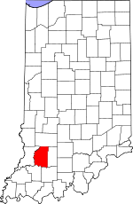
Adjacent counties:
Dubois  Greene  Knox  Martin  Pike  

Find in Indiana

Map of the Daviess County area


Our detail map of Daviess County shows the Daviess County, Indiana boundary lines and other interesting items.

Places in Daviess County, Indiana

  Airports     show all on map

Daviess County Airport

  Buildings     show all on map

Elnora - Elmore Volunteer Fire Department, Harrison Township Volunteer Fire Department Montgomery, Montgomery Volunteer Fire Department, Odon Volunteer Fire Department, Plainville Volunteer Fire Department, Southwest Medical Services, Veale Township Volunteer Fire Department, Waglers Greenhouse, Washington Fire Department Station 1, Washington Fire Department Station 2, Washington Township Volunteer Fire Department Station 1, Washington Township Volunteer Fire Department Station 2

  Canals     show all on map

Bethel Ditch, Colbert Ditch, Eagan Ditch, Epsom Lateral, Findley Lateral, Hawes Ditch, Hays Ditch, Kane Ditch, Killion Canal, Smothers Creek Cutoff, Thompson Ditch, Ventress Ditch, Vertrees Ditch, Weaver Ditch

  Cemeteries     show all on map

Alfordsville Cemetery, Belle Union Branch Cemetery, Bethel Cemetery, Colbert Cemetery, Concord Cemetery, Cornettsville Cemetery, East Union Cemetery, Ebenezer Cemetery, Evans Memorial Park, Fairview Cemetery, Fairview Cemetery, Ferguson Cemetery, Franklin Cemetery, Friendship Cemetery, Hawkins Cemetery, Humphries Cemetery, Ketchem Cemetery, Kilgore Cemetery, Liberty Cemetery, New Veale Creek Cemetery, Oak Grove Cemetery, Plainville Cemetery, Saint Johns Cemetery, Saint Patricks Glencoe Cemetery, Saint Peters Cemetery, Stoll Cemetery, Tolberts Chapel Cemetery, Wagler Cemetery, Walnut Hill Cemetery, Wells Cemetery

  Census     show all on map

Raglesville Census Designated Place

  Churches     show all on map

Aikman Church, All Saints Church, Antioch Church, Assembly of God Church, Baile Church, Berea Church, Bethany Church, Bethel Church, Bethel Church, Bethel Church, Cedar Grove Church, Mount Gilead Church, Mount Joy Church, Mount Olive Church, Mount Olive Church, Mount Olive Church, Mount Zion Church, Mud Pike Church, Oak Grove Church, Old Union Church, Pleasant Hill Church, Pleasant Hill Church, Saint Marys Church, Saint Michaels Church, Saint Patricks Church, Saint Peters Church, Shiloh Church, Sugarland Church, Union Chapel, Veale Creek Church, Zion Church, Zion Church

  Cliffs     show all on map

High Rock

  Dams     show all on map

Glendale Reservoir Dam, Prairie Creek Dam Number A-3-1, Prairie Creek Structure Number A-2-1, Prairie Creek Structure Number A-2-2, Prairie Creek Structure Number A-2-3, Prairie Creek Structure Number A-3-2, Prairie Creek Structure Number A-4-1, Prairie Creek Structure Number B-2-1, Prairie Creek Structure Number B-3-1, Prairie Creek Structure Number B-3-2, Prairie Creek Structure Number B-4-7, Wonder Pond Dam

  Forests     show all on map

Thousand Acre Woods

  Hospitals     show all on map

Daviess Community Hospital

  Islands     show all on map

Hyatt Island

  Lakes     show all on map

Big Piney Pond, Blue Hole Pond, Horseshoe Pond, Indian Pond, Jackson Pond, Little Piney Pond, Melton Pond, Snyder Pond, Swan Pond

  Levees     show all on map

Bennington Levee, Bennington Levee

  Locales     show all on map

Graber Poultry Farm, Washington Waterworks

  Parks     show all on map

East Side Park, Glendale State Fish and Wildlife Area

  Populated Places     show all on map

Alfordsville, Black Oak, Cannelburg, Capehart, Cornettsville, Corning, Cumback, Elnora, Epsom, Farlen, Glendale, Graham, Hudsonville, Jordan, Lettsville, Maysville, Montgomery, Odon, Pennyville, Plainville, Raglesville, Sandy Hook, South Washington, Thomas, Waco, Washington

  Reservoirs     show all on map

Dogwood Lake, Indian Rock Lake, West Boggs Lake, Wonder Pond

  Ridges     show all on map

Briar Ridge

  Schools     show all on map

Elnora Elementary School, Hickory Ridge School, Jefferson School, Letts School, Longfellow School, North Daviess Junior-Senior High School, North Elementary School, Parsons School, Raglesville School, Scudder School, South Side School, Southeast Center School, Sugarland School, Washington High School, Washington Junior High School, West End School, Whittier School

  Streams     show all on map

Aikman Creek, Antioch Creek, Barnes Branch, Camp Creek, Dinken Creek, East Fork Sugar Creek, East Fork White River, Flat Creek, Foberty Creek, Grindstone Branch, Hanna Creek, Hawkins Creek, Hurricane Branch, Mud Creek, North Fork Prairie Creek, Oberts Ditch, Prairie Creek, Rocky Branch, Smothers Creek, South Fork Prairie Creek, Sugar Creek, Veale Creek, West Fork Sugar Creek

  Summits     show all on map

Harbstreit Hill, Jolliff Rocks, Knob Hill, Knott Hill, Maumee Hill, Sefert Hill, Toms Hill

  Swamps     show all on map

Elmore Pond, The Lagoon

  Towers     show all on map

WAMN-AM (Washington), WFML-FM (Washington),

Daviess County, Indiana Population By Race (2012 estimate)

RacePopulation
WhiteDaviess County White population 31,35331,353  
MixedDaviess County Mixed population 258257
BlackDaviess County Black population 225225
AsianDaviess County Asian population 193193
American IndianDaviess County American Indian population 129128
Hawaiian & Pacific IslanderDaviess County Hawaiian & Pacific Islander population 3232

Additional population tables :
State population table
Indiana population by county