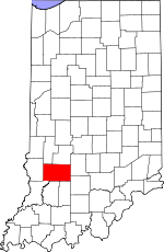
Greene County, Indiana Basics:


Greene County Indiana - Government Site

Population: 32,973
Area: 543 square miles
County seat: Bloomfield
Area code(s) in use: 812
Time zone: EST
High school graduate or higher: 84.1%
Bachelor's degree or higher: 11.3%
Median household income: $43,850
Persons in poverty: 14.3%
Home ownership rate: 77.4%
Mean travel time to work: 28.8 minutes


Adjacent counties:
Clay  Daviess  Knox  Lawrence  Martin  Monroe  Owen  Sullivan  

Find in Indiana

Map of the Greene County area


Our detail map of Greene County shows the Greene County, Indiana boundary lines and other interesting items.

Places in Greene County, Indiana

  Airports     show all on map

Benham Airport, Shakamak Airport, Shawnee Field Airport

  Basins     show all on map

Birch Bed, Long Bed, Nail Bed, Sipes Bed

  Bends     show all on map

American Bottoms, Bogard Bottoms

  Buildings     show all on map

Bloom Volunteer Fire Department, Bloomfield Volunteer Fire Department, Care Ambulance Service, Center Township Volunteer Fire Department, Eastern Volunteer Fire Department, Greene County Ambulance Service, Highland Township Volunteer Fire Department, Jackson Township Fire Department Owensburg Station, Jasonville Volunteer Fire Department, Linton Fire Department, Lyons Volunteer Fire Department, Richland - Taylor Township Volunteer Fire Department Richland Station, Richland - Taylor Township Volunteer Fire Department Taylor Station, Switz City Fire Department, Worthington - Jefferson Volunteer Fire Department, Wright Township Volunteer Fire Department

  Canals     show all on map

Armuth Ditch, Beehunter Ditch, Black Creek Ditch, Brewer Ditch, Bullock Ditch, Dayhoff Ditch, Dixon Ditch, Fourmile Ditch, Hamilton Ditch, Howesville Ditch, Ilene Ditch, Letsinger Ditch, Mc Kee Ditch, Nedigh Ditch, Ramsey Ditch, Shelkett Ditch, Simpson Ditch, Sloan Ditch, Timmons Ditch, Wells Ditch, Whorley Ditch

  Cemeteries     show all on map

Arthur Cemetery, Barton Cemetery, Beech Cemetery, Bethel Cemetery, Bingham Cemetery, Black Cemetery, Bogard Cemetery, Bohley Cemetery, Britton Cemetery, Bucher Cemetery, Bullerman Cemetery, Burch Cemetery, Burch Cemetery, Buzan Cemetery, Calvertville Cemetery, Campbell Cemetery, Carmichael Cemetery, Castle Hill Cemetery, Clayton Cemetery, Cooper Cemetery, Dishman Cemetery, Dixon Cemetery, Dowden Cemetery, Duke Cemetery, Edwards Cemetery, Fairview Cemetery, Flater Cemetery, Flynn Cemetery, Freeman Cemetery, Frye Cemetery, Fuller Cemetery, German Cemetery, Gilbreath Cemetery, Goodwin Cemetery, Greene County Chapel Cemetery, Griffith Cemetery, Hasler Cemetery, Hayes Cemetery, Holder Cemetery, Howell Cemetery, Hudson Cemetery, Island City Cemetery, Kelley Cemetery, Lawrence Cemetery, Livingston Cemetery, Livingston Cemetery, Marco Cemetery, Miller Cemetery, Minks Cemetery, Mount Nebo Church Cemetery, Mount Zion Cemetery, Mount Zion Cemetery, Newark Cemetery, Oak Grove Cemetery, Old Linton Cemetery, Old Slinkard Cemetery, Owens Cemetery, Philpot Cemetery, Pickard Cemetery, Pryor Cemetery, Richards Cemetery, Robison Cemetery, Rush Cemetery, Scafford Prairie Cemetery, Simpson Chapel Cemetery, Slinkard Cemetery, Smith-Bethel Cemetery, Snyder Cemetery, Solsberry Cemetery, Sparks Cemetery, Stalcup Cemetery, Stanley Cemetery, Steward Cemetery, Stone Cemetery, Switz City Cemetery, Tally Cemetery, Taylor Ridge Cemetery, Terhune Cemetery, Union Bethel Cemetery, Waggoner Cemetery, Wagoner Cemetery, Walker Cemetery, Wall Cemetery, Walnut Grove Cemetery

  Census     show all on map

Owensburg Census Designated Place, Scotland Census Designated Place

  Churches     show all on map

Allen Chapel, Antioch Church, Ashcraft Chapel, Bethany Church, Bethel Church, Bethel Church, Burris Chapel, Clifty Chapel, Ellis Church, Embury Church, Greene County Chapel, Harrah Chapel, Hicks Church, Kentucky Ridge Church, Lebanon Church, Liberty Church, Lincoln Church, Morris Chapel, Mount Calvary Church, Mount Nebo Church, Mount Vernon Church, Mount Zion Church, Olive Branch Church, Ore Branch Church, Pleasant Grove Church, Prairie Chapel, Providence Church, Ridgeport Church, Salem Church, Samaria Church, Sharkey Church, Simpson Chapel (historical), Stafford Church, Summersville Church, Sylvania Church, Tulip Church, Union Church, Union Valley Church, Walnut Church

  Cliffs     show all on map

Morgan Hill

  Crossings     show all on map

Farmers Ferry

  Dams     show all on map

Beechwood Lake Dam, Busseron Dam Number D-4, Dyer Lake Dam, Faulk Lake Dam, Gingerich Lake Dam, Jackson Lake Dam, Jason Lake Dam, Moses Lake Dam, Singer Ditch Dam, Tamerix Lake Dam, Thomas Lake Dam

  Flats     show all on map

Maple Flats

  Hospitals     show all on map

Greene County General Hospital

  Lakes     show all on map

Boat Lake, Boy Scout Pond, Long Pond

  Locales     show all on map

Latta Yard, Mount Zion Campground

  Parks     show all on map

Historical Marker USA Center of Population, Humphrey Park

  Populated Places     show all on map

Antioch, Beehunter, Bloomfield, Bushrod, Calvertville, Cincinnati, Dixon, Doans, Ellis, Elliston, Furnace, Gilmour, Hashtown, Hendricksville, Hobbieville, Hoosier, Ilene, Island City, Jasonville, Johnstown, Koleen, Linton, Lone Tree, Lyons, Marco, McVille, Midland, Midland Junction, Mineral City, Newark, Newberry, Owensburg, Park, Plummer, Point Commerce, Redcuff Corner, Ridgeport, Rincon, Scotland, Solsberry, Sponsler, Stalcup Corner, Summit, Switz City, Tanner, Tulip, Vicksburg, Victoria, White Rose, Worthington

  Post Offices     show all on map

Pleasant Ridge Post Office (historical)

  Rapidss     show all on map

Rock Riffle

  Reservoirs     show all on map

Beechwood Lake, Bennington Lake, County Line Lake, Dyer Lake, Harmons Lake, Jackson Lake, Lake Lenape, Moses Lake, Powell Pond, Sunflower Pond, Thomas Lake

  Ridges     show all on map

Feutz Ridge, Haney Ridge, Hard Scrabble Ridge, Kelley Ridge, Persimmon Ridge, Taylor Ridge

  Schools     show all on map

Bloomfield Elementary School, Bloomfield High School, Combs School, L and M Elementary and High School, Linton-Stockton High School, Linton-Stockton Junior High School, Sanbourn School, Shakamak Elementary School, Shakamak High School, Shakamak Middle School, Switz City Central School, Worthington Elementary School

  Springs     show all on map

Goad Spring, Osborne Spring, Rankin Spring, Rock Springs, Sexson Spring, Watkins Spring

  Streams     show all on map

Anderson Branch, Beech Creek, Black Ankle Creek, Bogard Creek, Bridge Creek, Buck Creek, Bunnell Branch, Burcham Branch, Camp Creek, Clark Creek, Clifty Branch, Cole Branch, Corbin Creek, Dead Horse Branch, Doans Creek, Dowden Branch, Dry Branch, Dry Branch, Eel River, Flyblow Branch, Fourmile Creek, Gilbert Creek, Goose Creek, Hall Branch, Jim Creek, Kelly Branch, Kisling Creek, Lattas Creek, Lemon Creek, Letsinger Branch, Little Clifty Branch, Little Indian Creek, Miller Branch, Miller Creek, Mitchell Branch, Mud Creek, Ore Branch, Plummer Creek, Ritter Branch, Skinner Branch, Stalcup Branch, Stone Branch, Town Branch, Wildcat Branch, Willow Slough, Woodhouse Branch

  Summits     show all on map

Brewer Hill, Fairplay Mound, Sand Hill, Simpson Hill, Tunnel Hill

  Swamps     show all on map

Goose Pond (historical)

  Towers     show all on map

WBTO-AM (Linton), WJCD-FM (Seymour), WQTY-FM (Linton)

  Valleys     show all on map

Bear Hollow, Blakeman Hollow, Freeze Hollow, Goose Hollow, Happy Hollow, Lawrence Hollow, Opossum Hollow, Possum Hollow,

Greene County, Indiana Population By Race (2012 estimate)

RacePopulation
WhiteGreene County White population 32,37932,379  
MixedGreene County Mixed population 297296
American IndianGreene County American Indian population 9998
BlackGreene County Black population 6665
Hawaiian & Pacific IslanderGreene County Hawaiian & Pacific Islander population 00

Additional population tables :
State population table
Indiana population by county