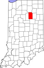
Wabash County, Indiana Basics:


Wabash County Indiana - Government Site

Population: 32,422
Area: 412 square miles
County seat: Wabash
Area code(s) in use: 765 260
Time zone: EST
High school graduate or higher: 85.8%
Bachelor's degree or higher: 16.0%
Median household income: $44,389
Persons in poverty: 14.0%
Home ownership rate: 75.3%
Mean travel time to work: 19.9 minutes


Adjacent counties:
Fulton  Grant  Huntington  Kosciusko  Miami  Whitley  

Find in Indiana

Map of the Wabash County area


Our detail map of Wabash County shows the Wabash County, Indiana boundary lines and other interesting items.

Places in Wabash County, Indiana

  Airports     show all on map

Servia Airport, Wabash Municipal Airport

  Bridges     show all on map

Red Bridge

  Buildings     show all on map

Chester Township Fire Department, Converse - Somerset Fire Department, La Fontaine - Liberty Township Fire Department, Lagro Volunteer Fire Department, LifeMed Emergency Medical Services, Lincolnville Volunteer Fire Department, Noble Township Volunteer Fire Department, Noble Township Volunteer Fire Department North, North Manchester Fire Department, Pleasant Township Fire Department, Roann Volunteer Fire Department, Urbana Volunteer Fire Department, Wabash Fire Department Station 1, Wabash Fire Department Station 2

  Canals     show all on map

Arthur Ditch, Beamer Ditch, Bolley Ditch, Busick Ditch, Hamilton Ditch, Johnson Ditch, Keafaber Ditch, Koontz Ditch, Kroft Ditch, Miller Ditch, Oren Ditch, Peebles Ditch, Sharp Ditch, Stauffer Ditch, Staver Ditch, Unger Ditch

  Cemeteries     show all on map

Abshire Cemetery, Algers Cemetery, Allbright Cemetery, America Cemetery, Center Grove Cemetery, Concord Cemetery, Daniel Cemetery, Fairview Cemetery, Foster Cemetery, Friends Cemetery, Gamble Cemetery, Gardner Cemetery, Glenwood Cemetery, Hale Cemetery, Harper Cemetery, Hebrew Cemetery, Huff Cemetery, Independent Order of Odd Fellows Cemetery, Independent Order of Odd Fellows Cemetery, Jack Cemetery, Krisher Cemetery, Laketon Cemetery, Leedy Cemetery, Long Cemetery, Martin Luther Cemetery, Matlock Cemetery, Memorial Lawns Cemetery, Mississinewa Memorial Cemetery, Mount Pleasant Cemetery, Moyer Cemetery, North Union Cemetery, Oaklawn Cemetery, Pleasant Hill Cemetery, Reeds Cemetery, Renicker Cemetery, Rennaker Cemetery, Richvalley Cemetery, Saint Patrick Cemetery, Shiloh Cemetery, Slocum Cemetery, Speicher Cemetery, Stone Cemetery, Swank Cemetery, Union Cemetery, Waggoner Cemetery, Wallace Cemetery

  Census     show all on map

Laketon Census Designated Place, Somerset Census Designated Place

  Churches     show all on map

Asbury Church, Bachelor Creek Church, Beech Grove Church, Bethel Church, Boundary Line Church, Christian Fellowship Church, Dora Christian Church, First Brethren Church, Hopewell Church, Lebanon Church, Niconza Church, North Manchester Congregational Christian Church, North Manchester United Methodist Church, Pleasant Grove Church, Saint Robert's Catholic Church, Salem Church, Silver Creek Church, West Manchester Church, Zion Evangelical Lutheran Church

  Dams     show all on map

Dick Thomas Pond Dam, Fearnow Lake Dam, Hominy Ridge Lake Dam, J Chamberlain Pond Dam, Johnson Heights Dam, Salamonie Dam

  Falls     show all on map

Shanty Falls

  Forests     show all on map

Salamonie River State Forest

  Hospitals     show all on map

Wabash County Hospital

  Islands     show all on map

Potter Island

  Lakes     show all on map

Bear Lake, Brown Lake, Flat Lake, Long Lake, Lotz Lake, McColley Lake, Mud Lake, Round Lake, Twin Lakes

  Locales     show all on map

Michel Hog Farm, Peabody Memorial Home, Rosen Hog Farm, Wabash Country Club

  Mines     show all on map

Higley Curve Gravel Pit

  Parks     show all on map

Dora New Holland State Recreation Area, Frances Slocum State Recreation Area, Hogback Ridge State Recreation Area, Lost Bridge State Recreation Area, Miami State Recreation Area, Mount Hope State Recreation Area, Pearson Mill State Recreation Area, Red Bridge State Recreation Area, Warvel Park

  Pillars     show all on map

Hanging Rock

  Populated Places     show all on map

America, Bolivar, College Corner, Disko, Ijamsville, La Fontaine, Lagro, Laketon, Liberty Mills, Lincolnville, Mount Vernon, Newton, North Manchester, Pioneer, Richvalley, Roann, Servia, Somerset, South Haven, Speicherville, Stockdale, Sunnymede, Treaty, Urbana, Valley Brook, Wabash

  Reserves     show all on map

Reserve Number Eleven, Reserve Number Fifteen, Reserve Number Fifty-five, Reserve Number Four, Reserve Number Fourteen, Reserve Number Nineteen, Reserve Number Seventeen, Reserve Number Sixteen, Reserve Number Thirteen, Reserve Number Three, Reserve Number Twelve, Reserve Number Twenty-six, Reserve Number Twenty-three, Reserve Number Two

  Reservoirs     show all on map

Bull Lake, Dick Thomas Pond, Fearnow Lake, Hominy Ridge Lake, J Camberlain Pond, Lake Niconzah, Lukens Lake, Mississinewa Lake

  Ridges     show all on map

The Hogback

  Schools     show all on map

Century School, Chester Elementary School, Chippewa School, Eastwood Elementary School, Lafontaine Elementary School, Laketon Elementary School, Latchum School, Linlawn School, Manchester College, Manchester High School, Manchester Junior High School, Maple Park Elementary School, Miami Elementary School, Northfield Junior-Senior High School, Roann Elementary School, Saint Bernard Elementary School, Southwood Elementary School, Southwood Junior-Senior High School, Thomas Marshall Elementary School, W C Mills Elementary School, Wabash Junior-Senior High School, Westwood School, White Institute

  Streams     show all on map

Asher Branch, Bachelor Creek, Back Creek, Badger Creek, Beargrass Creek, Burr Creek, Carlin Branch, Cart Creek, Charley Creek, Clear Creek, Engleman Creek, Enyeart Creek, Forked Branch, Gilbert Branch, Goose Creek, Grant Creek, Helm Creek, Indian Creek, Kentner Creek, Lagro Creek, Liston Creek, Logan Creek, Metocinah Creek, Mill Creek, Muddy Branch, Nordman Ditch, North Branch Grant Creek, Otter Creek, Paw Paw Creek, Pee Dee Creek, Pony Creek, Prairie Creek, Rager Creek, Ridgeway Creek, Rock Run, Rockaway Creek, Ross Run, Rush Creek, Silver Creek, Simonton Creek, Small Rush Creek, Squirrel Creek, Stone Creek, Swank Creek, Tenmile Creek, Treaty Creek

  Towers     show all on map

WAYT-AM (Wabash), WCRD-FM (Bluffton), WKJG-TV (Fort Wayne), WKUZ-FM (Wabash)

  Valleys     show all on map

Possum Hollow,

Wabash County, Indiana Population By Race (2012 estimate)

RacePopulation
WhiteWabash County White population 31,44931,449  
MixedWabash County Mixed population 357356
American IndianWabash County American Indian population 227226
AsianWabash County Asian population 195194
Hawaiian & Pacific IslanderWabash County Hawaiian & Pacific Islander population 00

Additional population tables :
State population table
Indiana population by county